Ground object target-oriented Gaofen-6 remote sensing satellite data validity detection method

A technology for remote sensing satellites and detection methods, applied in the field of satellite remote sensing, can solve the problems of negative influence of interfering factors, reduce target extraction efficiency, and high computational complexity, and achieve the effects of enhancing effectiveness, improving target extraction efficiency, and improving efficiency.

Pending Publication Date: 2020-03-17
SPACE STAR TECH CO LTD
View PDF4 Cites 6 Cited by
  • Summary
  • Abstract
  • Description
  • Claims
  • Application Information

AI Technical Summary

Problems solved by technology

[0003] Existing remote sensing satellite data validity detection methods need to detect each interfering factor in the image, even if the image does not contain interfering factors, a large number of calculations are required; when the image is too large, it often results in insufficient memory The situation; because the image contains a variety of complex ground objects and interfering factors, the detection of interfering factors will have a greater negative impact, and the computational complexity is also very high
[0004] When extracting ground object targets from all satellite remote sensing data, many data with serious interference factors that do not meet the requirements need to be extracted, which seriously reduces the efficiency of target extraction

Method used


Image

  • Ground object target-oriented Gaofen-6 remote sensing satellite data validity detection method
  • Ground object target-oriented Gaofen-6 remote sensing satellite data validity detection method
  • Ground object target-oriented Gaofen-6 remote sensing satellite data validity detection method

Examples


Embodiment Construction

[0055] Specific embodiments of the present invention will be further described in detail below in conjunction with the accompanying drawings.

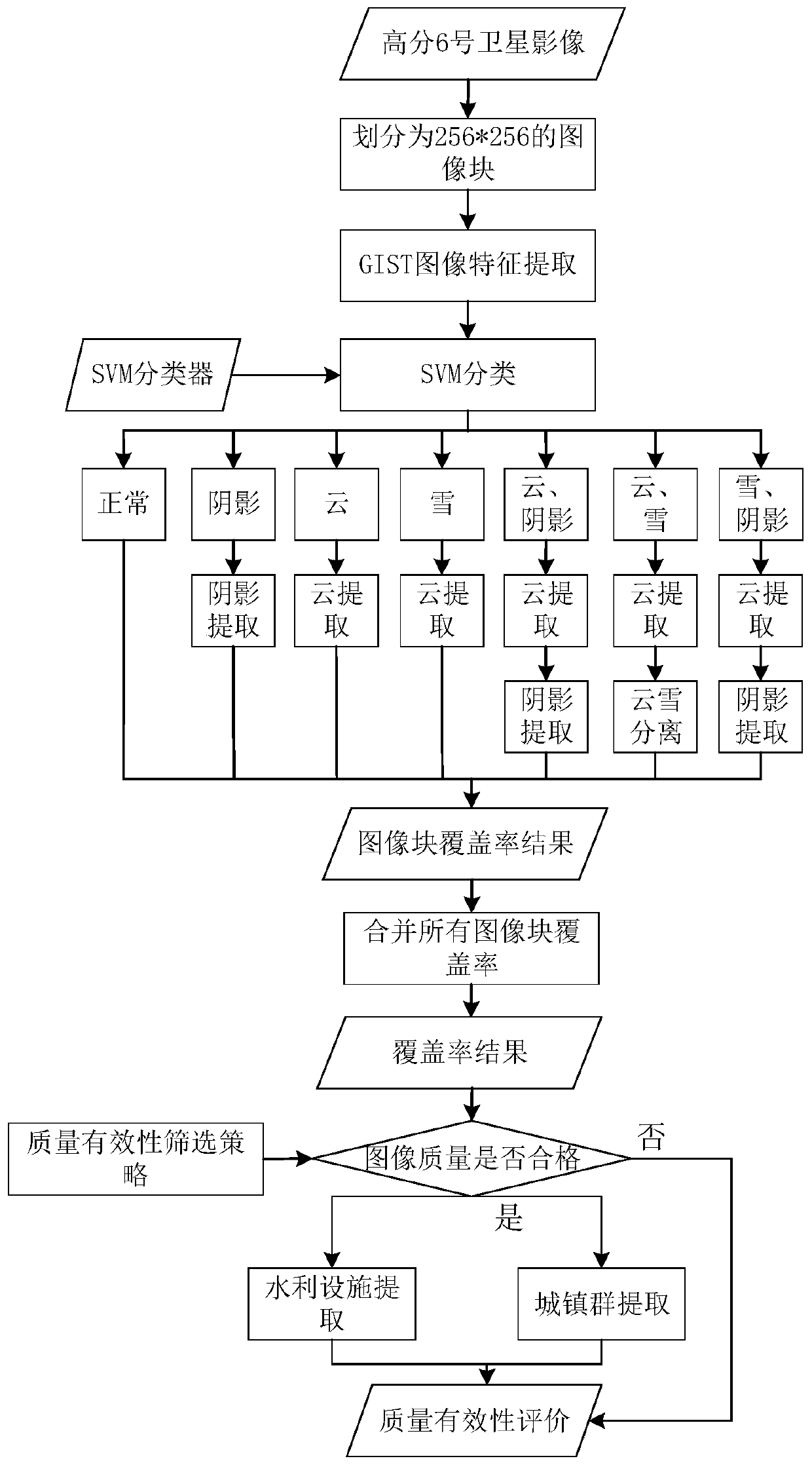
[0056] The effectiveness detection method of the Gaofen No. 6 remote sensing satellite data of the present invention, which is oriented to ground objects, mainly uses the data in the RGB band and the near-infrared band in the image data with a resolution of 2m to detect the interfering factors, thereby realizing fast effectiveness testing.

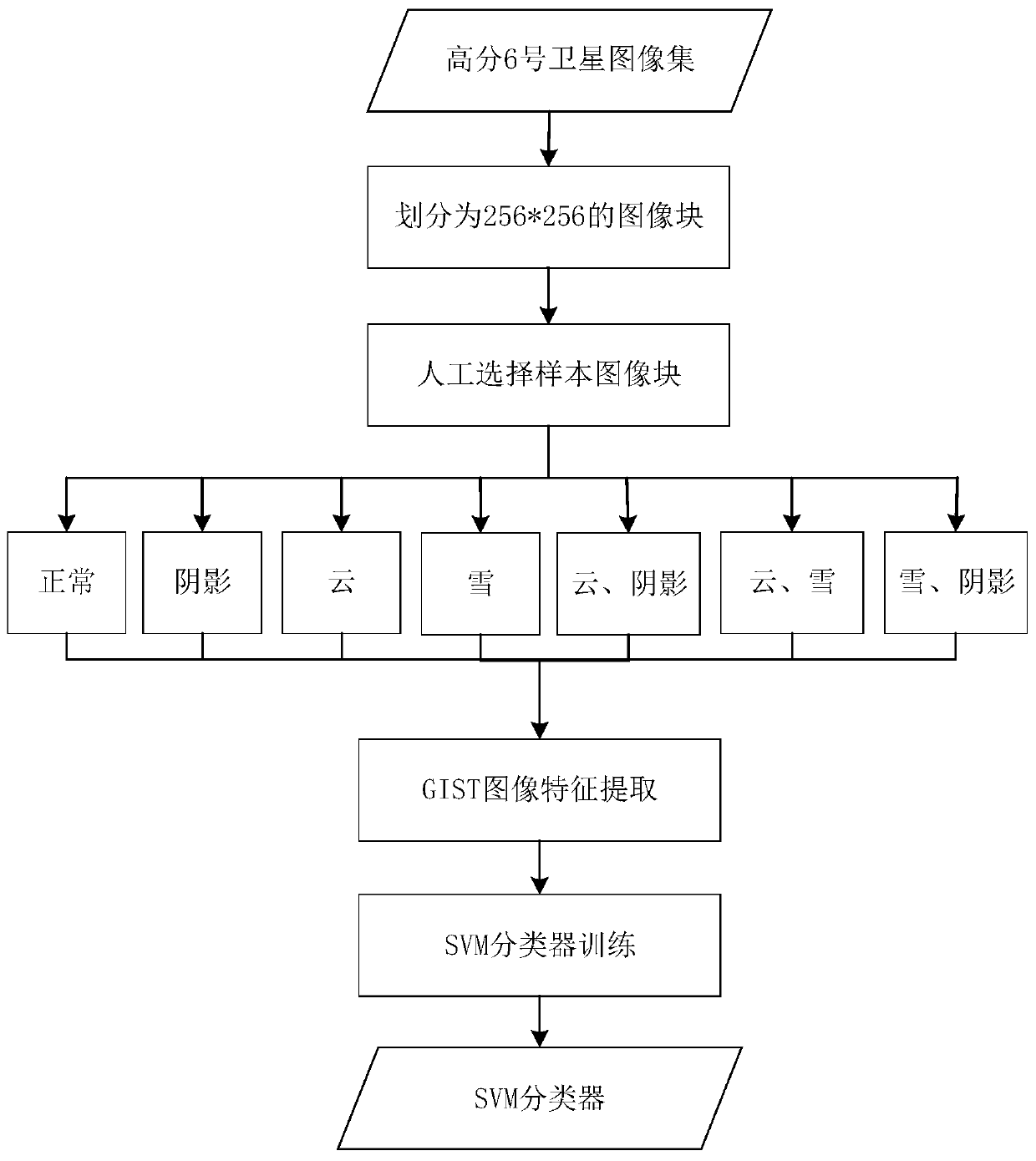
[0057] Such as figure 1 Shown is the SVM classifier training flowchart of the present invention, at first a large number of images are divided into blocks, artificially select representative image blocks for each situation to extract GIST image features, and the extracted features are input into the SVM classification model for Training, the parameters of model training use the automatic parameter selection method based on cross-validation, and the SVM classifier can be obtained after the training...


PUM


Abstract

The invention discloses a ground object target-oriented Gaofen-6 remote sensing satellite data validity detection method, relates to the technical field of satellite remote sensing, and aims to detectthe coverage rate of various interference factors in remote sensing satellite data so as to evaluate the validity of the remote sensing data. A partitioning method is adopted for the remote sensing image, and then detection is conducted based on image blocks; Gist image features are extracted from the image blocks, and then classification is performed on an SVM classifier based on the GIST imagefeatures; for classification results obtained by SVM classification, different detection processes are selected for detection according to different conditions; according to the method, the coverage rate of interference factors such as cloud, shadow and snow can be effectively detected for the Gaofen-6 remote sensing satellite data of any size, the effectiveness of the image data is rapidly and accurately evaluated, typical ground object target extraction is carried out on the image meeting the requirement, and the target extraction efficiency is effectively improved.

Description

technical field [0001] The invention relates to the technical field of satellite remote sensing, in particular to a method for detecting the validity of the data of the Gaofen No. 6 remote sensing satellite oriented to ground objects. Background technique [0002] Nowadays, with the continuous development of remote sensing satellite technology, the resolution of remote sensing satellite data is getting higher and higher, and more and more data are generated, but not all images can be effectively used. Clouds, snow, and shadows are common elements in satellite images. If the satellite images are blocked by the above-mentioned elements in the process of detecting the surface, the spectral characteristics of the surface will change. When the situation is serious, there will be many unobservable spots in the image The blind area brings a lot of inconvenience to the subsequent image interpretation and analysis. Since the pixels of these elements are invalid pixels, in most cases...

Claims


Application Information

Patent Timeline
Patent Type & Authority Applications(China)
IPC IPC(8): G06T7/00G06T7/11G06T7/136G06K9/62
CPCG06T7/0002G06T7/136G06T7/11G06T2207/10032G06T2207/20081G06F18/2411
Inventor 朱建勃赵裴李素菊和海峡姚静杨东高春苗刘健美晏立刚王苗
Owner SPACE STAR TECH CO LTD
Why Eureka
Try Eureka