A method for measuring the compactness of urban functional space combined with points of interest in electronic maps

A technology for electronic maps and city functions, applied in geographic information databases, structured data retrieval, instruments, etc., can solve problems such as defects in measurement methods, achieve comprehensive and compact features, accurately reflect, and improve correlation effects

Active Publication Date: 2022-05-24
INST OF URBAN ENVIRONMENT CHINESE ACAD OF SCI
View PDF5 Cites 0 Cited by
  • Summary
  • Abstract
  • Description
  • Claims
  • Application Information

AI Technical Summary

Problems solved by technology

Therefore, the measurement method of the compactness of construction land based on the development of the gravity model still has defects.

Method used


Image

  • A method for measuring the compactness of urban functional space combined with points of interest in electronic maps
  • A method for measuring the compactness of urban functional space combined with points of interest in electronic maps
  • A method for measuring the compactness of urban functional space combined with points of interest in electronic maps

Examples


Embodiment Construction

[0037] To further illustrate the various embodiments, the present invention is provided with the accompanying drawings. These drawings are a part of the disclosure of the present invention, and are mainly used to illustrate the embodiments, and can be used in conjunction with the relevant description of the specification to explain the operation principles of the embodiments. With reference to these contents, one of ordinary skill in the art will understand other possible embodiments and advantages of the present invention. Components in the figures are not drawn to scale, and similar component symbols are often used to represent similar components.

[0038] The present invention will now be further described with reference to the accompanying drawings and specific embodiments.

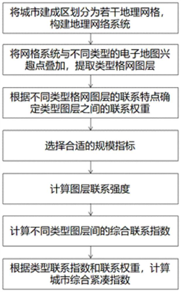
[0039] This embodiment provides a method for measuring the compactness of urban functional space combined with points of interest in an electronic map, and the method mainly includes the following st...


PUM


Abstract

The invention relates to a method for measuring the compactness of urban functional space combined with electronic map interest points. The method combines a grid system with different types of electronic map interest points to extract type grid layers, and calculates the connection index between different types of layers. , and then obtain the connection weight according to the determination of the connection type weights of different types of layers, and finally obtain the urban functional space compactness index by weighting, which realizes the quantitative research on the compactness of urban space and thus more comprehensively reflects the compactness characteristics of urban spatial form; The measurement of urban functional space compactness of electronic map POI improves the correlation between urban compactness index and urban travel time, and can reflect the actual characteristics of urban functional space more scientifically and accurately.

Description

technical field [0001] The invention relates to the intersection of urban geography, geographic information technology and national land space planning technology, in particular to a method for measuring the compactness of urban functional space combined with points of interest in electronic maps. Background technique [0002] The analysis, evaluation and planning technology of urban spatial form is an important branch of urban planning technology. Due to the rapid development of urbanization, the rapid changes in urban spatial form have brought various pressures to urban production, living and ecosystems, and affected the sustainable development of cities. The urban spatial form planning technology attempts to adjust the urban spatial form to cope with the development pressure brought about by urban expansion, and to realize the scientific and orderly development of the city by adjusting the urban spatial layout. Based on the need to curb the disorderly expansion of urban ...

Claims


Application Information

Patent Timeline
Patent Type & Authority Patents(China)
IPC IPC(8): G06Q10/06G06Q50/26G06F16/29
CPCG06Q10/0639G06Q50/26G06F16/29
Inventor 张国钦李妍叶红
Owner INST OF URBAN ENVIRONMENT CHINESE ACAD OF SCI
Why Eureka
Try Eureka