Urban agglomeration height space information and contour line extraction method

An extraction method and a technology of spatial information, applied in image data processing, 3D modeling, instruments, etc., can solve problems such as unfavorable urban horizontal area expansion and vertical height growth evolution pattern

Active Publication Date: 2020-04-21
INST OF GEOGRAPHICAL SCI & NATURAL RESOURCE RES CAS
View PDF4 Cites 13 Cited by
  • Summary
  • Abstract
  • Description
  • Claims
  • Application Information

AI Technical Summary

Problems solved by technology

However, little is involved in the system framework for extracting urban building information and building height information, which is not conducive to studying the evolution pattern of urban horizontal area expansion and vertical height growth

Method used


Image

  • Urban agglomeration height space information and contour line extraction method
  • Urban agglomeration height space information and contour line extraction method
  • Urban agglomeration height space information and contour line extraction method

Examples


Embodiment 1

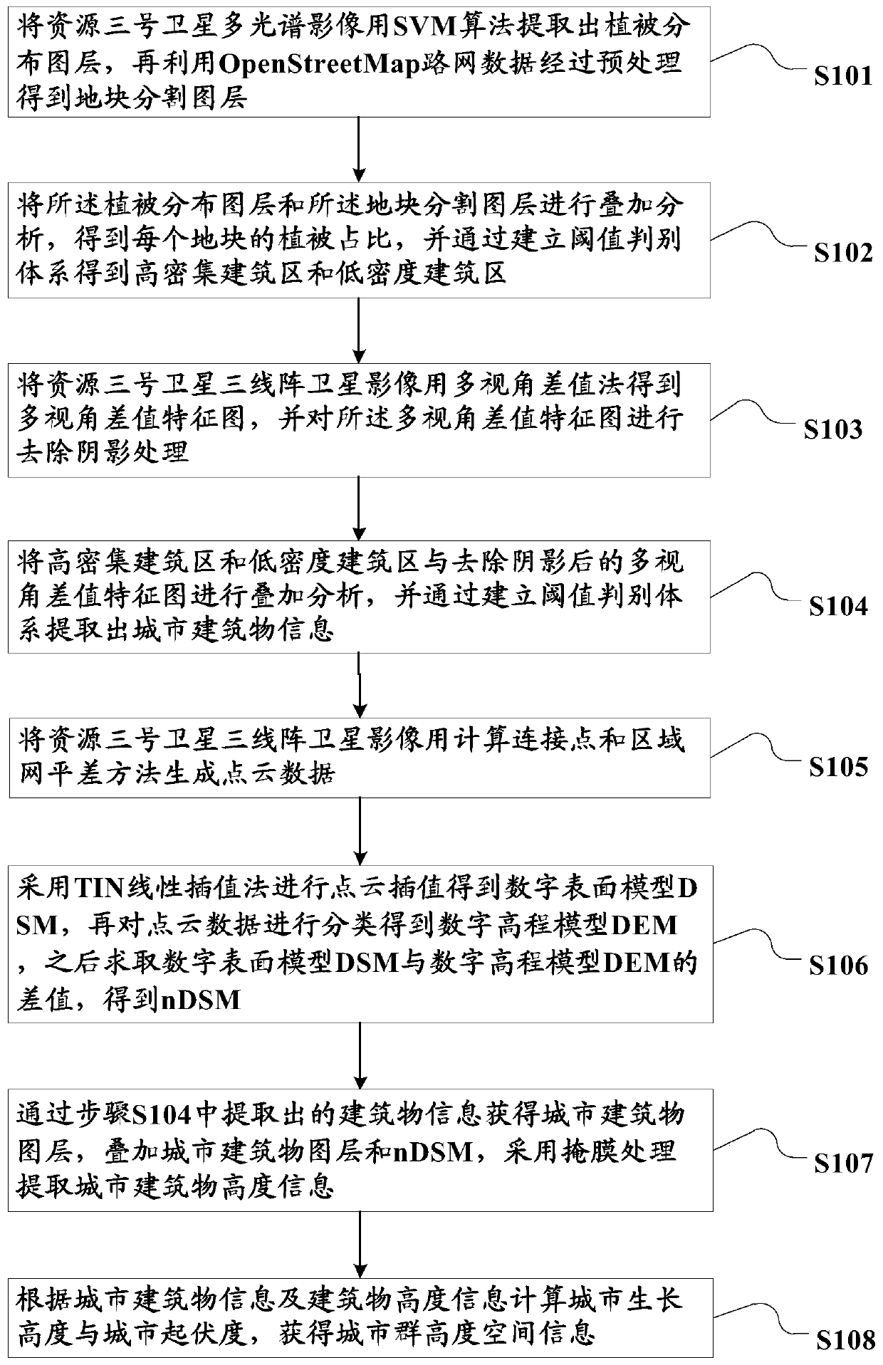
[0128] In order to further illustrate the method for extracting urban building information and building height information of the present invention, some areas in Beijing are selected as the research area for illustration below.

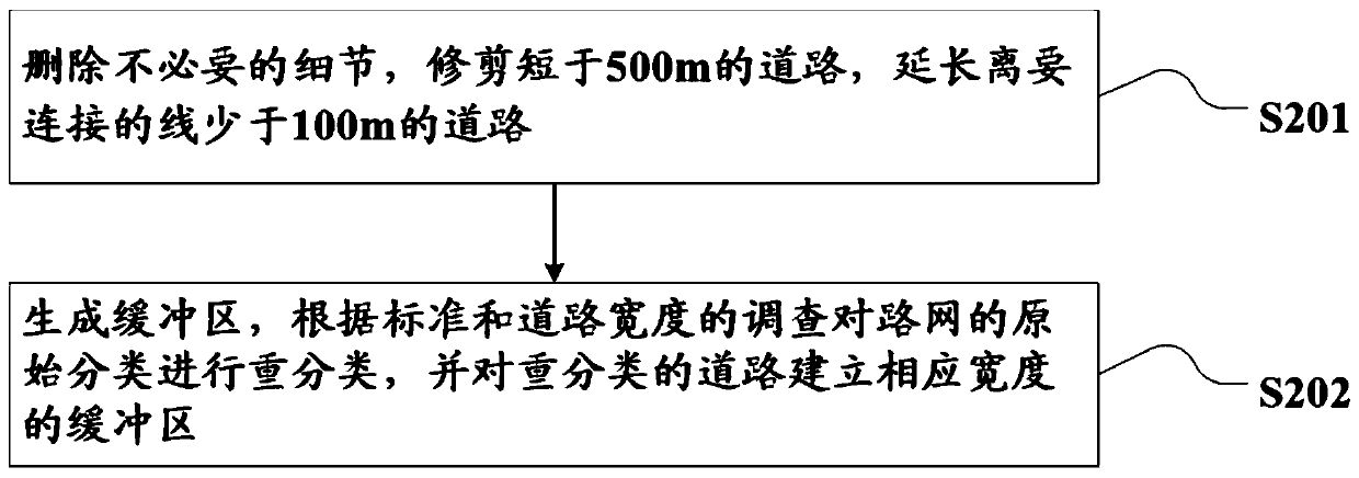
[0129] First, use the SVM algorithm to get Figure 7 The vegetation layer shown, and then use the road data to get the following Figure 8 The parcel layer shown;

[0130] Then use the multi-view difference method to get the multi-view difference feature map, from Figure 9 It can be seen that buildings and other land types show obvious differences in the multi-view difference feature map. The buildings are brighter overall, and the higher the area, the brighter the color; Figure 10 It is the final urban building distribution obtained by superimposing high / low density building areas and threshold analysis on the multi-view difference feature map after shadow removal processing.

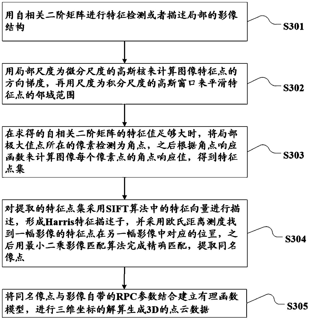
[0131] For the extraction of building height, use Harris operator, ...


PUM


Abstract

The invention relates to an urban agglomeration height space information and contour line extraction method. the method is characterized in that , for extraction of urban buildings, remote sensing data and social perception data are fused, a high/low density building area of a plot scale is established, and the extraction of the urban buildings is realized by combining a multi-view difference feature map; for extraction of urban building heights, dense point clouds are generated by matching every two of forward-looking, backward-looking and front images of a resource No.3, a digital surface model is solved by adopting a TIN linear interpolation method, the thought of point cloud classification is introduced, accurate ground points are obtained, and a digital elevation model is established.According to the invention, the forward-looking, backward-looking and front images of the resource No.3 are fully utilized, and a system framework for extracting urban building information and building height information is innovatively constructed, models of an urban contour line, an urban undulation degree and an urban growth height are obtained on the basis of the system framework, and an evolution pattern of urban transverse area expansion and longitudinal height increase is revealed.

Description

technical field [0001] The invention relates to the field of data information processing, in particular to an information presentation method, in particular to a method for extracting height space information and contour lines of urban agglomerations. Background technique [0002] With the continuous increase of China's urban population and the acceleration of urbanization, urban land is expanding rapidly. Urban expansion includes the horizontal expansion of urban buildings and the vertical height growth. Urban buildings are an important part of urban planning, management and informatization. The height of buildings is the process of urban monitoring, urban three-dimensional reconstruction, and urban pollution diffusion simulation. basic information. Therefore, comprehensive consideration of urban horizontal area expansion and vertical height growth is very important for the study of urban spatial morphological characteristics and the simulation of urban landscape. [0003...

Claims


Application Information

Patent Timeline
Patent Type & Authority Applications(China)
IPC IPC(8): G06T17/05G06T17/10G06T7/33G06K9/62G06K9/46
CPCG06T17/05G06T17/10G06T7/33G06T2207/10028G06T2207/30181G06V10/44G06V10/462G06F18/2411
Inventor 方创琳杨智奇
Owner INST OF GEOGRAPHICAL SCI & NATURAL RESOURCE RES CAS
Why Eureka
Try Eureka