Three-dimensional investigation method for dangerous falling rock based on air-borne laser radar

A technology of airborne laser radar and rockfall of dangerous rock, which is applied in the direction of electromagnetic wave re-radiation, special data processing application, and utilization of re-radiation, etc. The effect of reducing labor intensity and high precision

Active Publication Date: 2014-01-22
CHINA RAILWAY SIYUAN SURVEY & DESIGN GRP
View PDF3 Cites 30 Cited by
  • Summary
  • Abstract
  • Description
  • Claims
  • Application Information

AI Technical Summary

Problems solved by technology

[0013] The purpose of the present invention is to solve the defects in the dangerous rockfall investigation method in the above-mentioned background technology, which is based on manual investigation and supplemented by aerial and satellite film interpretation, and provides a method that can accurately determine the distribution range of

Method used


Image

  • Three-dimensional investigation method for dangerous falling rock based on air-borne laser radar
  • Three-dimensional investigation method for dangerous falling rock based on air-borne laser radar
  • Three-dimensional investigation method for dangerous falling rock based on air-borne laser radar

Examples


Embodiment Construction

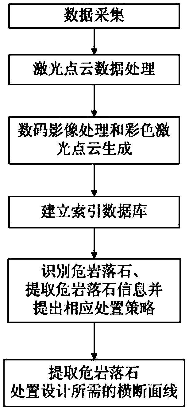
[0032] The present invention will be further described in detail below in conjunction with the accompanying drawings and specific embodiments to facilitate a clear understanding of the present invention, but they do not limit the present invention.

[0033] Such as figure 1 As shown, the method of the embodiment of the present invention includes the following steps:

[0034] The first step is data collection. According to the characteristics of the project and the actual situation, the aircraft is used as a platform to carry various equipment for collection. The laser scanner is used to collect the original laser point cloud data covering the area where the project is located, and the digital imaging equipment is used to collect and cover the area where the project is located. For the original image data of the area, use the global positioning system GPS and the inertial navigation system INS to collect the initial outer orientation elements of the image, and the scanning and ...


PUM


Abstract

The invention discloses a three-dimensional investigation method for a dangerous falling rock based on an air-borne laser radar. Original laser point cloud data and original video image data which cover an engineering zone and the initial exterior orientation elements of the original video image data are collected and processed to generate a DEM (Digital Elevation Model), a DOM (Digital Orthophoto Map) and a color laser point cloud. An index database is generated, the dangerous falling rock is recognized by information in the index database, the information factors of the dangerous falling rock are extracted to classify the hazard rate of the dangerous falling rock and provide a treatment strategy, and cross section lines required by a treatment design are extracted. The high-precision color laser point cloud, the high-precision DEM and the high-precision DOM are established by the advanced space-to-land observation technology based on the air-borne laser radar, the information extraction, quantitative analysis and risk evaluation of the dangerous falling rock are realized, and a novel method for surveying mountain hazards based on the air-borne laser radar technology is created.

Description

technical field [0001] The method relates to a dangerous rockfall investigation method, in particular to a three-dimensional dangerous rockfall investigation method based on an airborne laser radar. Background technique [0002] Dangerous rockfall in complex mountainous areas is one of the important geological disasters, which has the characteristics of many disaster points, wide distribution, strong suddenness, and unpredictability. In the construction of railway and highway engineering projects in mountainous areas, it is necessary to carry out the investigation of dangerous rockfalls, so as to determine the distribution position, scale and impact on engineering hazards of dangerous rockfalls near the line. [0003] The existing rockfall investigation methods for dangerous rocks are mainly based on manual investigation and supplemented by aerial and satellite film interpretation. The main problems of this method are: [0004] (1) Heavy investigation workload: In complex m...

Claims


Application Information

Patent Timeline
IPC IPC(8): G01S17/88G01S7/48
CPCG01S7/4802G01S17/89G06F16/583
Inventor 冯光胜李海亮曹柏树高山刘善勇陈世刚岳永兴汪继峰
Owner CHINA RAILWAY SIYUAN SURVEY & DESIGN GRP
Why Eureka
Try Eureka