Method and system for preprocessing multi-road segment data of lane line crowdsourcing data

A lane line, preprocessing technology, applied in special data processing applications, road network navigators, geographic information databases, etc., can solve the problem of low accuracy of crowdsourced data, and achieve the effect of improving effect and efficiency

Active Publication Date: 2021-07-16
WUHAN ZHONGHAITING DATA TECH CO LTD
View PDF10 Cites 0 Cited by
  • Summary
  • Abstract
  • Description
  • Claims
  • Application Information

AI Technical Summary

Problems solved by technology

[0004] Aiming at the technical problems existing in the prior art, the present invention provides a preprocessing method and system for multi-road segment data of lane line crowdsourcing data, and solves the problem of low accuracy of crowdsourcing data in the prior art

Method used


Image

  • Method and system for preprocessing multi-road segment data of lane line crowdsourcing data
  • Method and system for preprocessing multi-road segment data of lane line crowdsourcing data
  • Method and system for preprocessing multi-road segment data of lane line crowdsourcing data

Examples


Embodiment 1

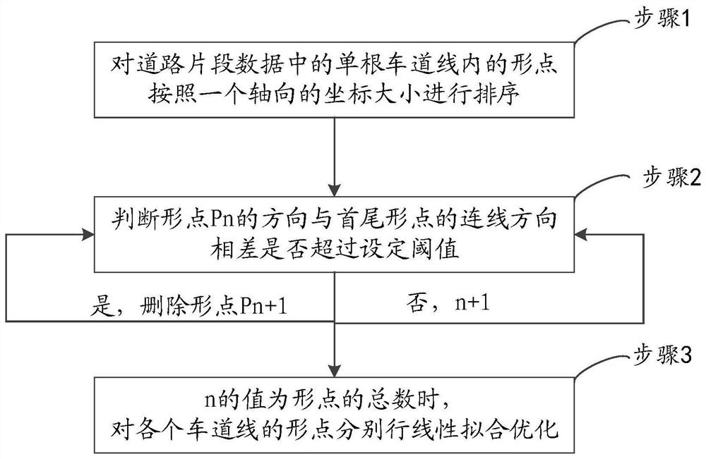
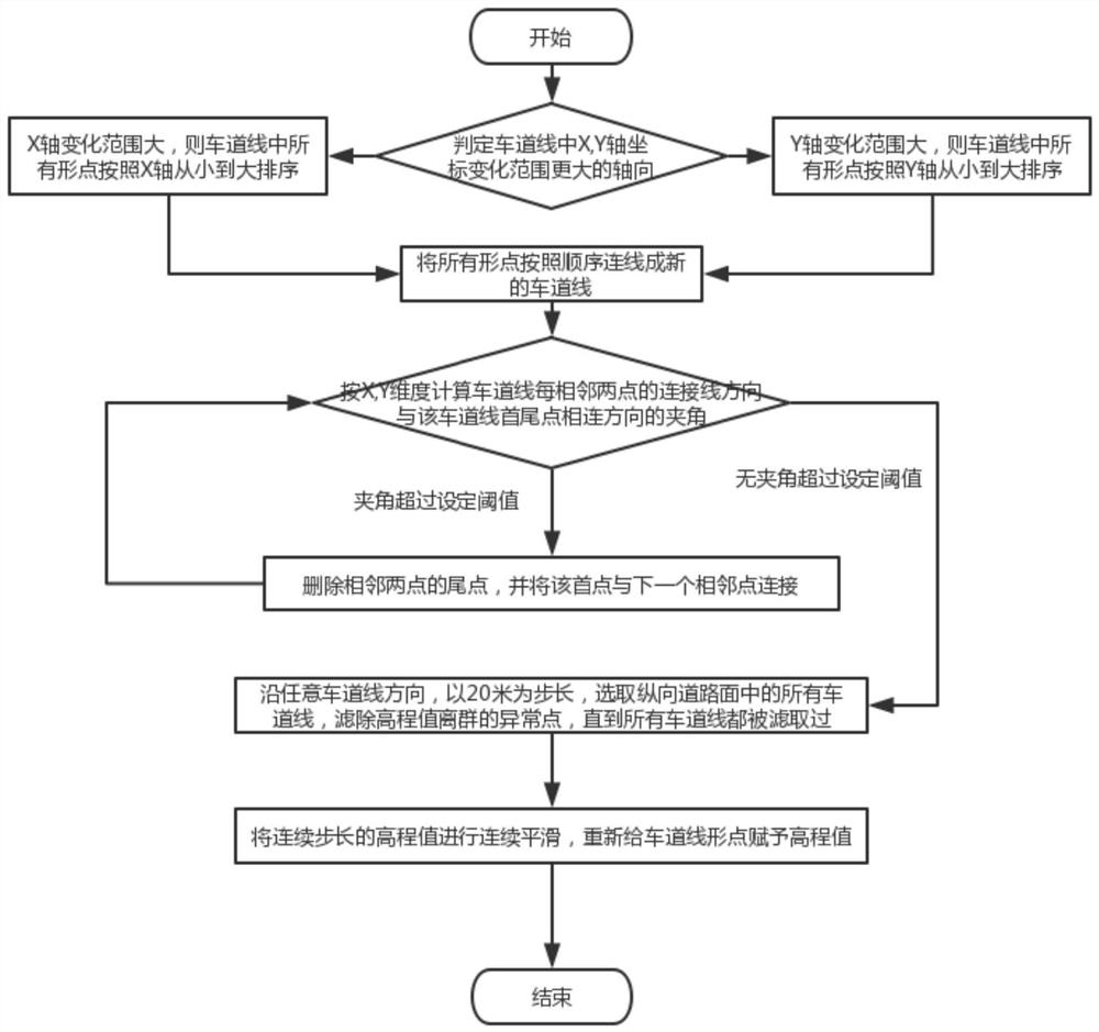
[0047] Embodiment 1 provided by the present invention is an embodiment of a method for preprocessing multi-road segment data of lane line crowdsourcing data provided by the present invention, such as figure 2 Shown is a flow chart of an embodiment of a method for preprocessing multi-road segment data of lane line crowdsourcing data provided by the present invention, consisting of figure 2 As can be seen, the embodiment of this pretreatment method comprises:

[0048] Based on the longitude, latitude and altitude coordinates given by the road segment data and the range of the projection zone, the coordinate conversion is carried out, and the coordinates of the multi-road segment data are converted into plane coordinates by using the Gauss-Krüger projection method.

[0049] Step 1, sort the shape points in a single lane line in the road segment data according to the size of an axial coordinate.

[0050] Preferably, step 1 includes: comparing the variation ranges of X-axis and Y-...

Embodiment 2

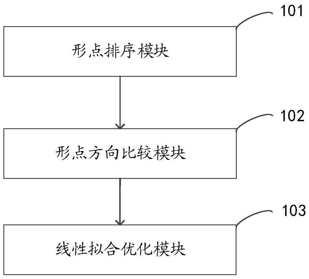
[0072] Embodiment 2 provided by the present invention is an embodiment of a preprocessing system for multi-road segment data of lane line crowdsourcing data provided by the present invention, such as figure 2 Shown is a structural block diagram of an embodiment of a preprocessing system for multi-road segment data of lane line crowdsourcing data provided by the present invention, consisting of figure 2 It can be seen that the system includes: a shape point sorting module 101 , a shape point direction comparison module 102 and a linear fitting optimization module 103 .

[0073] The shape point sorting module 101 is used to sort the shape points in a single lane line in the road segment data according to the size of an axial coordinate.

[0074] Shape point direction comparison module 102, for judging shape point p n Whether the difference between the direction of the point and the connection direction of the head and tail points exceeds the set threshold; yes, delete the poi...


PUM


Abstract

The present invention relates to a method and system for preprocessing multi-road segment data of lane line crowdsourcing data. The method includes: step 1, according to the size of an axial coordinate of the shape points in a single lane line in the road segment data Sort; step 2, judge shape point p n Whether the difference between the direction of the point and the connection direction of the head and tail points exceeds the set threshold; yes, delete the point p n+1 , no, add 1 to n; among them, the shape point p n The direction of the shape point p n and shape point p n+1 The connection direction of the line; step 3, execute step 2 in a loop until the value of n is the total number of shape points, and perform linear fitting optimization on the shape points of each lane line respectively. Sorting the shape points in each lane line according to the collinear relationship between points, filtering out abnormal outliers, effectively preprocessing the lane line data collected by crowdsourcing collection vehicles, and improving the efficiency of subsequent optimization processing Effect and efficiency, in order to obtain high-precision lane line map data that meets the accuracy requirements.

Description

technical field [0001] The present invention relates to the field of high-precision maps, in particular to a method and system for preprocessing multi-road segment data of lane line crowdsourcing data. Background technique [0002] In the field of autonomous driving, in order to accurately control the driving of vehicles, the drawing of high-precision maps is often involved. High-precision maps can be drawn after long-term data collection by expensive surveying and mapping vehicles. However, due to high costs, long collection periods, and slow update The reason is that it is difficult to meet the high freshness requirements of high-precision maps. [0003] Compared with high-precision surveying and mapping vehicles, the cost of crowdsourcing collection vehicles is lower, and it is more suitable for extensive deployment to collect high-quality data and improve the update frequency of high-precision maps. Large and often wrong data points cannot be directly used for optimizat...

Claims


Application Information

Patent Timeline
Patent Type & Authority Patents(China)
IPC IPC(8): G01C21/32G06F16/29
CPCG01C21/32G06F16/29
Inventor 秦峰尹玉成朱紫威肖德雨罗跃军
Owner WUHAN ZHONGHAITING DATA TECH CO LTD
Why Eureka
Try Eureka