Unmanned aerial vehicle three-dimensional environment modeling method based on vision-assisted laser radar

A lidar and auxiliary laser technology, applied in 3D modeling, image data processing, instruments, etc., can solve problems such as depth direction error, limited depth perception distance, and inability to work.

Active Publication Date: 2020-05-26
NANJING UNIV OF AERONAUTICS & ASTRONAUTICS +1
View PDF10 Cites 12 Cited by
  • Summary
  • Abstract
  • Description
  • Claims
  • Application Information

AI Technical Summary

Problems solved by technology

However, the binocular vision sensor also has shortcomings such as limited image accuracy, depth direction error gradually increases with distance, resulting in limited depth perception distance, and inability to work in scenes where feature points are missing....

Method used


Image

  • Unmanned aerial vehicle three-dimensional environment modeling method based on vision-assisted laser radar
  • Unmanned aerial vehicle three-dimensional environment modeling method based on vision-assisted laser radar
  • Unmanned aerial vehicle three-dimensional environment modeling method based on vision-assisted laser radar

Examples


Embodiment Construction

[0058] The present invention is described in further detail now in conjunction with accompanying drawing.
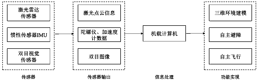
[0059] The design idea of ​​the UAV 3D environment modeling system based on the visual aided lidar: such as figure 1 As shown, the designed UAV 3D environment modeling system collects corresponding data through sensors and transmits them to the onboard computer. The corresponding sensor data is collected and processed synchronously on the onboard computer, and relevant algorithm software programs are run to realize the 3D environment. Modeling, autonomous obstacle avoidance and autonomous flight. Among them, the laser point cloud information provided by the lidar and the binocular image information provided by the binocular camera are used to calibrate the binocular camera and the lidar respectively; the onboard computer effectively fuses the information provided by the lidar and the binocular camera to carry out Based on the design of the laser radar odometer based on ...


PUM


Abstract

The invention discloses an unmanned aerial vehicle three-dimensional environment modeling method based on a vision-assisted laser radar. The method comprises the following steps: calibrating a binocular camera based on a Zhang Zhengyou calibration method; then, adopting an external parameter calibration method on the camera/laser radar based on a 3D marker method; and finally, using the binocularvision odometer as high-frequency assistance of the laser radar odometer, providing off-site point rejection and a relative pose initial value for the laser radar odometer so that the laser radar odometer operates at a low frequency, and movement is further optimized by utilizing the relative pose initial value provided by the binocular vision odometer. According to the invention, high-precision modeling of the flight environment of the unmanned aerial vehicle is realized, a foundation is laid for autonomous obstacle avoidance of the unmanned aerial vehicle, safe flight of the unmanned aerialvehicle is ensured, a reliable channel is provided for acquisition of intelligence and resource information, and the combat effectiveness is improved.

Description

technical field [0001] The invention relates to the field of image processing and control of unmanned aerial vehicles, in particular to a three-dimensional environment modeling method for unmanned aerial vehicles based on visual aided laser radar. Background technique [0002] The multi-UAV formation cooperative combat mode can give full play to combat effectiveness and enhance combat effectiveness, and has gradually become a hot research topic today. It is said that the U.S. Defense Advanced Research Projects Agency has planned to launch highly intelligent drones that can be used in actual combat in 2025. Intelligent UAV formation requires UAVs to be able to identify and monitor obstacles that may be encountered on the flight path in real time, so as to formulate reasonable avoidance strategies, and finally complete established tasks, such as transporting materials, detecting terrain and striking targets Wait. Therefore, UAVs must have the ability to model the surrounding...

Claims


Application Information

Patent Timeline
IPC IPC(8): G06T17/00G06T7/13G06T7/80
CPCG06T17/00G06T7/13G06T7/80
Inventor 刘蓉肖颖峰熊智羊书杰
Owner NANJING UNIV OF AERONAUTICS & ASTRONAUTICS
Why Eureka
Try Eureka