A landslide disaster prediction method and device

A prediction method and disaster technology, applied in prediction, data processing applications, instruments, etc., can solve the problems of incomplete consideration of landslide prediction methods, inaccurate prediction results, etc., to avoid secondary damage, enhance practicability, and ensure safety Effect

Active Publication Date: 2022-07-26
SICHUAN DEPT OF TRANSPORTATION HIGHWAY PLANNING PROSPECTING & DESIGN RES INST
View PDF5 Cites 0 Cited by
  • Summary
  • Abstract
  • Description
  • Claims
  • Application Information

AI Technical Summary

Problems solved by technology

[0005] The purpose of the present invention is to provide a landslide disaster prediction method and device, which can comprehensively reflect the impact of rainfall in the monitoring area on time and space, in view of the incomplete consideration of landslide prediction methods in the prior art, resulting in inaccurate prediction results. process response, accurately predict the possibility and scope of landslide occurrence, and provide a basis for risk assessment

Method used


Image

  • A landslide disaster prediction method and device
  • A landslide disaster prediction method and device
  • A landslide disaster prediction method and device

Examples


Embodiment 1

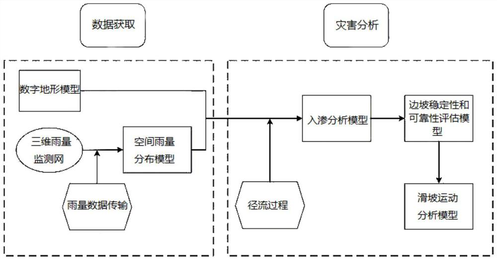
[0063] A landslide disaster prediction method, which constructs a landslide disaster prediction model, such as figure 2 , including the following steps:

[0064] 1. Obtaining data

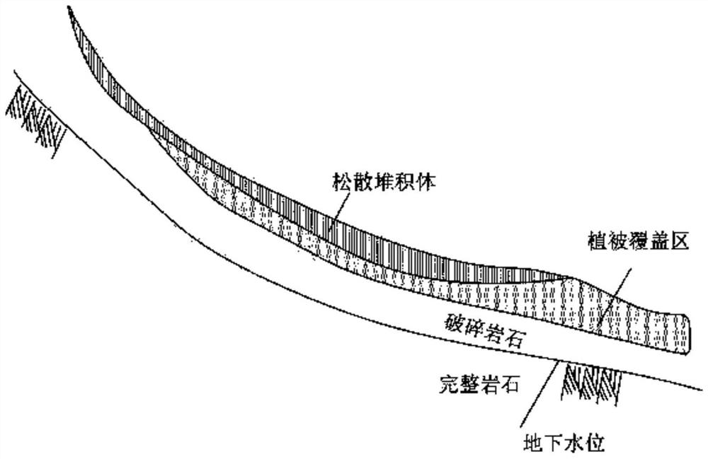
[0065] Establish a digital terrain model, divide the study area into grids, each grid is regarded as a unit, and give each unit corresponding geological information, spatial rainfall distribution information and other hydrological information, such as elevation, slope, geological classification, rainfall information, soil thickness, groundwater level and soil parameters.

[0066] When establishing a digital terrain model, the dense elevation point data can be obtained by field surveying and mapping with terrain surveying and mapping instruments, and a DEM (Digital Elevation Model, digital elevation model) can be established on this basis; DEM; or use the existing paper topographic map to digitize the topographic map vector DEM through software.

[0067] 2. Disaster Analysis

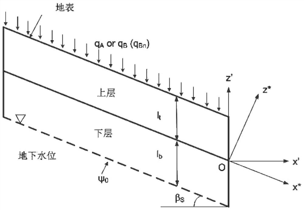
[0068] 1. Infiltr...

Embodiment 2

[0155] The present invention provides a landslide prediction device based on the prediction method in Embodiment 1. The device includes at least one processor and a memory connected in communication with the processor; the memory stores at least one instruction executable by the corresponding processor, and the instruction is executed by the corresponding processor. The processor executes, so that the processor can execute all or part of the method steps described in Embodiment 1.

[0156] All or part of the steps for implementing the above method embodiments can be completed by program instructions related to hardware, and the aforementioned instruction programs can be stored in a computer-readable storage medium. When the program is executed, it executes the steps including the above method embodiments. When the above-mentioned integrated units of the present invention are implemented in the form of software functional units and sold or used as independent products, they may ...


PUM


Abstract

The invention relates to the field of geological disaster risk assessment, in particular to a landslide disaster prediction method and device. First, a digital terrain model is established, a research area is divided into grids, each grid is regarded as a unit, and each unit is assigned the required geological and rainfall distribution information; perform infiltration analysis to obtain pore water pressure; based on pore water pressure, use the infinite slope model to calculate the safety factor and obtain the instability probability to judge the stability and reliability of the slope; collect a large amount of historical landslide data , the empirical relationship used to calculate the average value of the landslide movement distance is obtained through regression analysis; the unstable units connected with at least one side or one corner are grouped into a group, and a group is regarded as a landslide, the location and volume of the landslide are confirmed, and the landslide movement The distance relationship is used as the cessation condition of the landslide movement to evaluate the movement trajectory and accumulation position of the landslide body, and then predict the impact area of ​​the landslide, and provide a scientific basis for post-disaster reconstruction and disaster early warning work.

Description

technical field [0001] The invention relates to the field of geological disaster risk assessment, in particular to a landslide disaster prediction method and device. Background technique [0002] Rainfall has a great impact on landslides. Due to the infiltration of a large amount of rainwater, the soil-rock layer on the slope is saturated, and even water accumulates on the aquifer at the lower part of the slope, thereby increasing the weight of the sliding body and reducing the shear strength of the soil-rock layer. , resulting in landslides. If landslides cannot be prevented and controlled in time, they will not only cause traffic jams, threaten the safety of people's lives and property, but also cause major secondary hazards. [0003] When considering rainwater infiltration, the heterogeneity of the soil or rock mass can have a significant impact on the infiltration process; the soil mass is layered in places such as figure 1 The slope in is a typical slope with layered ...

Claims


Application Information

Patent Timeline
Patent Type & Authority Patents(China)
IPC IPC(8): G06Q10/04G06Q50/26G08B21/10
CPCG06Q10/04G06Q50/265G08B21/10
Inventor 何云勇向波汪晓锋魏琨
Owner SICHUAN DEPT OF TRANSPORTATION HIGHWAY PLANNING PROSPECTING & DESIGN RES INST
Why Eureka
Try Eureka