Multi-source remote sensing image pixel-by-pixel classification method based on correlation fusion network

A technology that integrates network and remote sensing images, applied in the field of image processing

Active Publication Date: 2020-06-16
XIDIAN UNIV
View PDF4 Cites 7 Cited by
  • Summary
  • Abstract
  • Description
  • Claims
  • Application Information

AI Technical Summary

Problems solved by technology

At the same time, the edge sample processing and loss function have been improved

Method used


Image

  • Multi-source remote sensing image pixel-by-pixel classification method based on correlation fusion network
  • Multi-source remote sensing image pixel-by-pixel classification method based on correlation fusion network
  • Multi-source remote sensing image pixel-by-pixel classification method based on correlation fusion network

Examples


Embodiment Construction

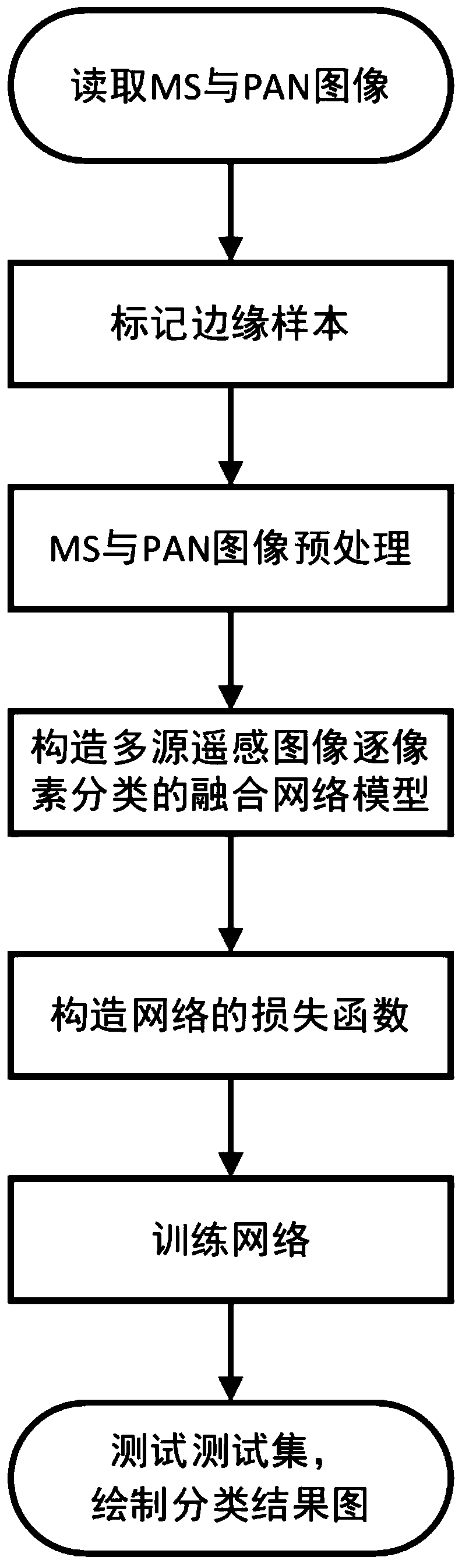
[0060] The invention provides a pixel-by-pixel classification method of multi-source remote sensing images based on a correlation fusion network, which reads MS and PAN images from the data set; marks edge samples according to superpixels and clustering algorithms; and normalizes the images , to build a training set and a test set; construct a fusion network model for pixel-by-pixel classification of multi-source remote sensing images; reconstruct the loss function of the network according to the edge sample marks and the size of the loss value; train the model, and use the trained classification model to test the data set Classification. The invention introduces the feature interaction fusion module of MS and PAN image branches and the structure of the loss function of pixel-by-pixel classification, which improves the classification performance and can be used for multi-source image classification and pixel-by-pixel classification tasks.

[0061] see figure 1 , a pixel-by-pi...


PUM


Abstract

The invention discloses a multi-source remote sensing image pixel-by-pixel classification method based on a correlation fusion network, and the method comprises the steps: reading a multi-spectral image from a data set,wherein the multi-spectral image comprises registered PAN and MS image data and a corresponding class sign true image with only a part of regions; marking an edge sample; respectively preprocessing the PAN image and the MS image, and selecting a training set and a test set; constructing a fusion network model of multi-source remote sensing image pixel-by-pixel classification; constructing a network loss function; training the classification model by using the training data set to obtain a trained classification model; and classifying the test data set by using the trained classification model to obtain the category of each pixel point in the test data set. According to the invention, the classification performance is improved, and the improved loss function strategy improves the pixel-by-pixel classification performance of the remote sensing image.

Description

technical field [0001] The invention belongs to the technical field of image processing, and in particular relates to a pixel-by-pixel classification method of multi-source remote sensing images based on a correlation fusion network, which can be used in related fields such as environmental monitoring, land coverage, urban construction, and other related fields of classification of remote sensing images. Background technique [0002] Nowadays, with the development of geospatial information technology and the support of advanced equipment technology, high-resolution and multi-spectral information in the same scene can be obtained simultaneously. However, due to technical limitations, a single sensor cannot achieve this goal, so multispectral (MS) images and panchromatic (PAN) images with higher spatial resolution can be obtained with the help of current multiple sensors. The specific MS image contains RGB and near-infrared spectral information, while the PAN image is a single...

Claims


Application Information

Patent Timeline
Patent Type & Authority Applications(China)
IPC IPC(8): G06K9/62G06T7/11G06N3/04G06N3/08
CPCG06T7/11G06N3/08G06T2207/10036G06T2207/20221G06T2207/20192G06T2207/20081G06N3/045G06F18/23213G06F18/241G06F18/214
Inventor 马文萍周晓波朱浩李龙伟武越
Owner XIDIAN UNIV
Why Eureka
Try Eureka