Building elevation measurement method based on PSInSAR technology

A technology for elevation measurement and building, applied in height/level measurement, measurement device, radio wave measurement system, etc., can solve problems such as high cost and regulatory restrictions, and achieve the effect of high degree of automation and rapid estimation

Active Publication Date: 2020-06-19
北京东方至远科技股份有限公司
View PDF5 Cites 1 Cited by
  • Summary
  • Abstract
  • Description
  • Claims
  • Application Information

AI Technical Summary

Problems solved by technology

The white film of urban buildings is mainly composed of building vectors and building elevations. Large-scale building vector frames can be obtained on optical satellite basemaps; while large-scale urban building elevations are relatively complicated to obtain, generally t

Method used


Image

  • Building elevation measurement method based on PSInSAR technology
  • Building elevation measurement method based on PSInSAR technology
  • Building elevation measurement method based on PSInSAR technology

Examples


Embodiment

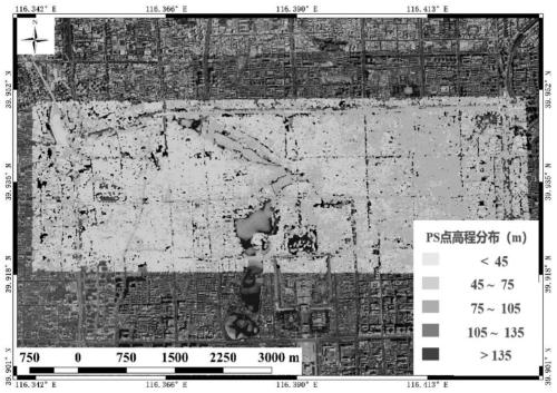
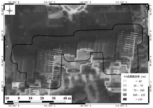
[0056] Such as Figure 2-5 Shown are the PSInSAR data result display map of Beijing Dongsi in the embodiment of the present invention, the PS point distribution map of a certain house in Dongsi, the ground elevation map of Dongsi area, and the elevation map of houses in Dongsi area.

[0057] Taking the area near Dongsi, Beijing as an example, from September 2011 to November 2017, a total of 96 episodes of SAR data, the satellite heading angle is 11.9°, the satellite attitude is ascending orbit, the downward viewing angle of the satellite center is 20°, and the spatial resolution is 3m × 3m, the width is 40km, the time interval is relatively uniform, and the time interval is about once a month, and the data quality is relatively good.

[0058] Using the PS algorithm, a large Beijing InSAR database is produced, with a total of more than 20 million PS points, and the PS points in the vicinity of Beijing Dongsi are intercepted, such as figure 2 As shown, the external input East ...


PUM


Abstract

The invention discloses a building elevation measurement method based on a PSInSAR technology. The method specifically comprises the steps of S1 based on data of multiple high-resolution SAR images ofa target city, generating an InSAR big database through a permanent scatterer synthetic aperture radar interferometry technology, and obtaining PS point three-dimensional space position information of the target city; S2 introducing a statistical theory and a signal estimation method, and performing spatial grading twice estimation based on three-dimensional spatial positions of all PS point datain a target range to obtain urban ground elevation; S3 introducing a building vector box, selecting PS points in each building, clustering the PS point elevations in the building, removing wrong points, and calculating the roof elevation ; and S4 obtaining the height of the building by subtracting the ground PS point elevation from the roof PS point elevation. Data acquisition is not limited by the airspace; related data can be obtained in a large range; the automation degree is high; and the elevation of the urban house building can be quickly estimated.

Description

technical field [0001] The invention relates to the technical field of synthetic aperture radar interferometry, in particular to a method for measuring building elevation based on PSInSAR technology. Background technique [0002] With the promotion of the concept of smart city, urban quantification and urban digitalization are more and more favored by city managers. Among them, the white film of urban buildings has a certain market value as its base map. The white film of urban buildings is mainly composed of building vectors and building elevations. Large-scale building vector frames can be obtained on optical satellite basemaps; while large-scale urban building elevations are relatively complicated to obtain, generally through Lidar technology, and Lidar accuracy is relatively high. High, but corresponding to the high cost, and the main carrier of Lidar is drones and aircraft platforms. At present, most cities in China are banned from flying, and there are certain regulato...

Claims


Application Information

Patent Timeline
IPC IPC(8): G01S13/90G01C5/00
CPCG01C5/00G01S13/9023
Inventor 朱茂谢传高吴隐王松松李吉平
Owner 北京东方至远科技股份有限公司
Why Eureka
Try Eureka