The Method of Analyzing igso Satellite's Area Covering Arc Based on Characteristic Points

A technology of area coverage and feature points, applied in navigation, instrumentation, surveying and navigation, etc., can solve problems such as inapplicability, and achieve the effect of realizing calculation efficiency and improving calculation and analysis efficiency

Active Publication Date: 2021-12-31
BEIJING INST OF SPACECRAFT SYST ENG
View PDF8 Cites 0 Cited by
  • Summary
  • Abstract
  • Description
  • Claims
  • Application Information

AI Technical Summary

Problems solved by technology

[0005] In view of this, the present invention provides a method for analyzing the arcs covered by IGSO satellites to the region based on marker points, which solves the problem that the calculation method of geometric positioning factors of all sampling points in the region in the navigation task and the GEO satellite coverage capability analysis method in the communication task cannot be applied Due to the flaws in the analysis of IGSO satellite area target coverage capabilities, it is possible to analyze the period during which satellites can achieve continuous coverage for specified irregular areas on the ground under the constraints of ground elevation angle and satellite opening angle, and achieve calculation efficiency on the basis of ensuring correctness According to the obtained IGSO satellite coverage arc, guide the subsequent practical engineering application of using IGSO satellite for satellite-to-ground communication

Method used


Image

  • The Method of Analyzing igso Satellite's Area Covering Arc Based on Characteristic Points

Examples


Embodiment 1

[0035] A method for analyzing an arc segment covered by an IGSO satellite based on a feature point, the specific process is as follows:

[0036] According to the given initial moment and orbit parameters, and set the time step, based on the orbital dynamics equation, calculate the position component of the satellite in the geocentric inertial system corresponding to each moment of each interval of the time step within a specified period of time; According to the given target area, determine its corresponding marker point;

[0037] Determine whether the IGSO satellite can cover the target area at each time interval of the time step within the specified period, record the corresponding time that can be covered, and form a coverage arc according to the recorded time; whether the IGSO satellite can The basis for judging the coverage of the target area is to calculate the critical opening angle corresponding to each marker point and the satellite opening angle according to the sate...

Embodiment 2

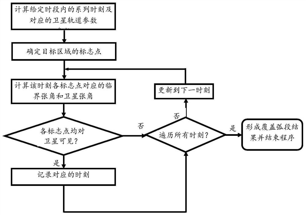
[0039] Such as figure 1 Shown is the analysis flow chart of this implementation method. In this embodiment, a method for analyzing an arc segment covered by an IGSO satellite based on a feature point, the specific process is:

[0040] (1) According to the given initial moment and orbital parameters, the orbital parameters include semi-major axis, eccentricity, orbital inclination, right ascension of ascending node, argument of perigee and true anomaly, and convert the initial orbital parameters into satellite’s position and velocity;

[0041] Based on the orbital dynamics equation considering the influence of gravity at the center of the earth and the perturbation of the J2 term, set the step size to calculate the component of the satellite position in the geocentric inertial system at each moment within the specified period, where the calculation step size can be adjusted , which is 1min by default.

[0042] (2) Determine the corresponding marker points according to the gi...


PUM


Abstract

The present invention provides a method for analyzing the arcs covered by IGSO satellites to the region based on feature points. The process is: according to the given initial moment and orbital parameters, and setting the time step, calculating each interval time step in the specified time period. The position of the satellite corresponding to the time in the geocentric inertial system; according to the given target area, determine its corresponding marker point; judge whether the IGSO satellite can cover the target area at each time step in the specified period , record the corresponding time that can be covered, and form a coverage arc according to the recorded time; whether the IGSO satellite can cover the target area is: according to the satellite position, calculate the critical opening angle corresponding to each marker point and the satellite opening angle to judge, when When there is a marker point that is invisible to the IGSO satellite, it is considered that the IGSO satellite cannot cover the target area at the corresponding moment. According to the obtained IGSO satellite coverage arc, guide the subsequent practical engineering application of using IGSO satellite for satellite-ground communication.

Description

technical field [0001] The invention relates to a method for analyzing an arc segment covered by an IGSO satellite based on a feature point, and belongs to the technical field of space-based navigation and communication. Background technique [0002] IGSO refers to the geosynchronous geosynchronous orbit. Because its orbital period is the same as the earth's rotation period and has a certain inclination angle, it is projected on the ground as a closed curve similar to a figure-eight. The coverage of IGSO satellites changes continuously. When the inclination angle is greater than a certain value, IGSO satellites can cover the polar regions, so they have more advantages than GEO satellites. At present, the application field of my country's in-orbit IGSO satellites is mainly navigation. In the future, it can be considered to provide communication services for large-scale target areas including polar regions. [0003] In traditional communication tasks, the coverage area of ​​G...

Claims


Application Information

Patent Timeline
Patent Type & Authority Patents(China)
IPC IPC(8): G01C21/20G01C21/16
CPCG01C21/20G01C21/165
Inventor 雪丹任迪刘庆军潘鑫胡雪梅盛靖王璐
Owner BEIJING INST OF SPACECRAFT SYST ENG
Why Eureka
Try Eureka