
A 3D Visual Modeling Method for Highway Slope

A modeling method and 3D model technology, applied in 3D modeling, construction, excavation, etc., can solve problems such as poor user experience, increased image processing workload, high server requirements, etc. experience good results

Active Publication Date: 2022-04-05
CHINA MERCHANTS CHONGQING COMM RES & DESIGN INST
View PDF8 Cites 0 Cited by
  • Summary
  • Abstract
  • Description
  • Claims
  • Application Information

AI Technical Summary

Problems solved by technology

[0004] Although there are already many methods for constructing 3D visualization models, there are still many inconveniences and shortcomings:
[0005] 1. At present, there is still a lack of modeling methods for primary structures such as highway slopes. Common modeling techniques can model structural components, but the modeling of slopes is still vague and the resolution cannot reach project requirements, and cannot provide assistance for project monitoring and maintenance;
[0006] 2. At present, the establishment of 3D visualization models is still in its infancy. If you want to obtain ideal resolution and display effect, you can only rely on obtaining a large number of pictures on the spot. The collection of a large number of pictures is not only a complicated process, but also a large workload, time-consuming and labor-intensive. It wastes manpower and increases the workload of image processing in the later stage. At the same time, due to the large number of images and the large amount of accumulated model data, the loading on the platform requires high server requirements, and the loading speed is too slow when browsing, which is not conducive to fast Check, the user experience is extremely poor;
[0007] 3. The currently established model is only a three-dimensional model of the shallow surface terrain. It cannot reproduce and display information such as the stratum structure, geological form, and underground layout of structures inside the slope. The model is simple and has little information.
This has brought great inconvenience to geologists. When consulting relevant information, it is necessary to cooperate with historical design data, relevant construction data and other complex graphics to understand the slope situation, and cannot provide assistance for engineering work.

Method used


Image

  • A 3D Visual Modeling Method for Highway Slope
  • A 3D Visual Modeling Method for Highway Slope

Examples


Embodiment Construction

[0036] The implementation mode of the present invention is illustrated by specific specific examples below, and those who are familiar with this technology can easily understand other advantages and effects of the present invention from the contents disclosed in this description. Obviously, the described embodiments are a part of the present invention. , but not all examples. Based on the embodiments of the present invention, all other embodiments obtained by persons of ordinary skill in the art without making creative efforts belong to the protection scope of the present invention.

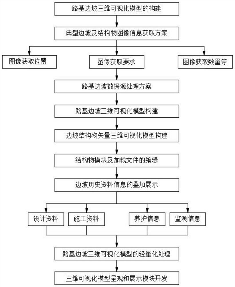
[0037] The present invention carries out the research on the three-dimensional visualization model of the roadbed slope structure, aiming at the current problem that the information of the roadbed slope is scattered and complicated, it is difficult to consult and the display is not intuitive, etc., comprehensive application of geographic information (GIS), virtual reality (VR), big data management...


PUM


Abstract

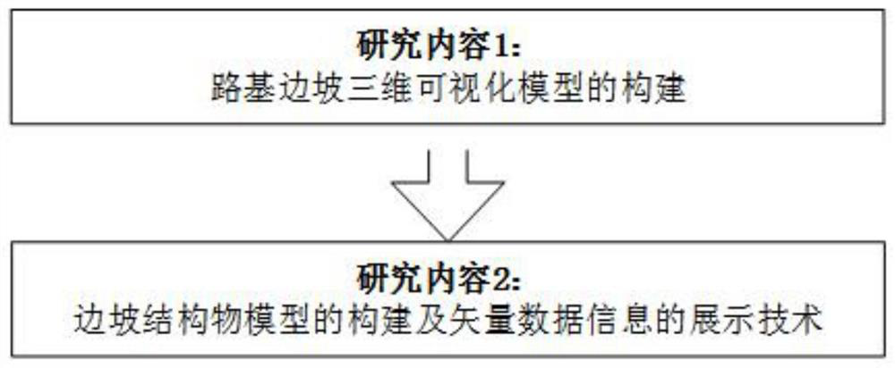
The invention discloses a three-dimensional visualization modeling method for road slopes, and specifically relates to the technical field of road slope modeling, including the following modeling steps: S1, construction of a three-dimensional visualization model of roadbed slopes; S2, construction of slope structure models Construction and display of vector data information. The present invention comprehensively applies geographic information, virtual reality, big data management, roadbed slope engineering and other technologies to study the construction and navigation technology of the three-dimensional visualization real scene model of the roadbed slope, build a three-dimensional visualization scheme of the slope and solve the model in " Compatible display technical problems on the "Cloud Eye" system platform, and at the same time integrate and process the vector data of the structures on the slope body, build a three-dimensional visualization model of the structures, and integrate the basic information of the roadbed slope, protection and reinforcement structure, construction process, safety The monitoring and maintenance information is fused and displayed intuitively, clearly and selectively through the three-dimensional model, and the loading speed is fast when browsing, and the user experience is good.

Description

technical field [0001] Embodiments of the present invention relate to the technical field of road slope modeling, and in particular to a three-dimensional visualization modeling method for road slopes. Background technique [0002] In recent years, with the rapid rise of computer technology and graphics acceleration hardware, visualization technology has also made a qualitative leap. Today is an era of information and data, and information technology is penetrating into various fields of economy and society. Highway slope engineering should also keep up with the development pace of today's information age, and apply high-tech means in the field of information technology to provide direct and effective road safety intelligence. Favorable support, how to achieve it is particularly important. Establish a complete three-dimensional visualization modeling technology for highway slopes, timely and accurately provide geological basis or model data for highway slope engineering sta...

Claims


Application Information

Patent Timeline
Patent Type & Authority Patents(China)
IPC IPC(8): G06T17/00G06F30/13E02D17/20E02D33/00
CPCG06T17/00E02D17/20E02D33/00G06T2200/04E02D2600/10
Inventor 杜孟秦黄河谭玲阎宗岭张小松
Owner CHINA MERCHANTS CHONGQING COMM RES & DESIGN INST
Learn More