Check patentability & draft patents in minutes with Patsnap Eureka AI!

A position calculation method of ads-b based on spaceborne scene

A solution and scene technology, applied in the field of civil aviation surveillance, to achieve the effect of improving recognition rate, improving accuracy, and avoiding repeated judgments

Active Publication Date: 2021-02-26
NO 54 INST OF CHINA ELECTRONICS SCI & TECH GRP
View PDF5 Cites 0 Cited by
  • Summary
  • Abstract
  • Description
  • Claims
  • Application Information

AI Technical Summary

Problems solved by technology

The development of spaceborne ADS-B aviation surveillance technology is an important direction for future air traffic management. Currently, this technology is in its infancy, and many applications are still in the discussion and exploration stage, but there is no doubt that spaceborne ADS-B surveillance Technology set to have a profound impact on the future of air traffic management

Method used


Image

  • A position calculation method of ads-b based on spaceborne scene
  • A position calculation method of ads-b based on spaceborne scene
  • A position calculation method of ads-b based on spaceborne scene

Examples


Embodiment Construction

[0022] The present invention will be further described below in conjunction with the accompanying drawings.

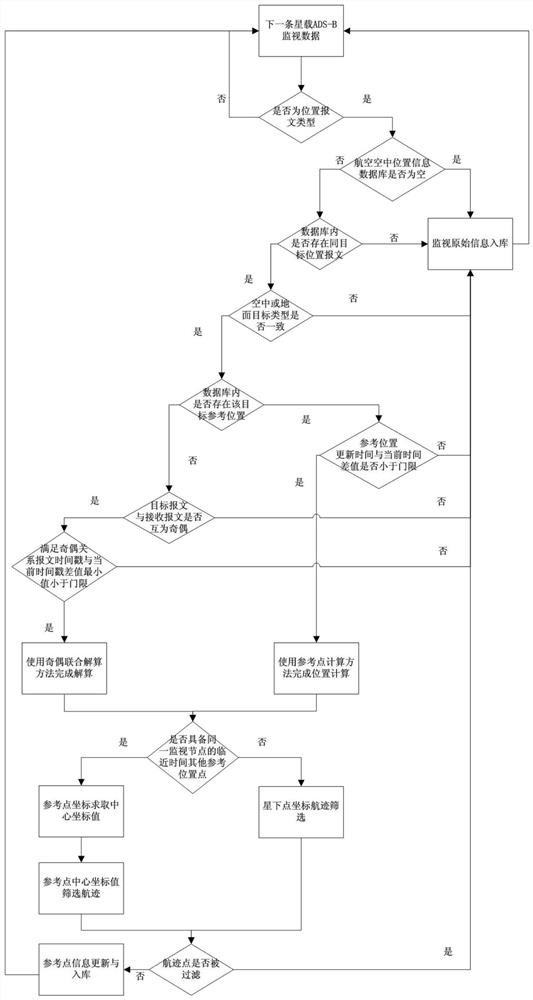
[0023] An ADS-B position calculation method based on a space-borne scene. The ground control center first receives the monitoring data from the space-borne ADS-B, judges whether the data type is position information, and then uses the reference point calculation method or parity after identifying the position information. The joint calculation method completes the calculation of the position information, so as to obtain the flight position of the aircraft in time. figure 1 is the flow chart of the algorithm, according to figure 1 To elaborate on the algorithm:

[0024] (1) Determine the location message type

[0025] First, the ground control center receives the monitoring data sent by the on-board ADS-B, and judges whether its type is a position message type. If it is not a position message type, return to wait for the next piece of monitoring data and judge its da...


PUM


Abstract

The invention discloses an ADS-B position calculation method based on a space-borne scene. The ground control center first receives the monitoring data from the space-borne ADS-B, judges whether the data type is position information, and passes the reference point after identifying the position information. The calculation method or the odd-even joint calculation method completes the calculation of the position information, so as to obtain the flight position of the aircraft in time. Finally, it is judged whether to update and store the reference point information according to the track point filtering situation. Compared with the current ADS‑B position calculation method, the present invention realizes the step-by-step judgment of position information, and has the advantages of high recognition rate, high calculation accuracy and high efficiency.

Description

technical field [0001] The present invention relates to the field of civil aviation surveillance, in particular to an ADS-B position calculation method based on a space-borne scene, mainly through the space-borne ADS-B receiver to obtain the flight state information of the aircraft, and the ground control center uses the CPR algorithm to calculate the position of the aircraft. The latitude and longitude location information. Background technique [0002] ADS-B (Automatic Dependent Surveillance-Broadcast), also known as Automatic Dependent Surveillance-Broadcast, is a surveillance technology widely used in air traffic control systems. It has been widely used in the field of civil aviation surveillance worldwide. . The ADS-B system continuously broadcasts the location information (latitude, longitude and altitude), identity and category information, and working status of the aircraft in the surveillance area through a specific wireless data link. The aircraft and the ground c...

Claims


Application Information

Patent Timeline
Patent Type & Authority Patents(China)
IPC IPC(8): G08G5/00
CPCG08G5/0082
Inventor 叶红军郎兴康刘亮贾诗雨王振华蔚保国
Owner NO 54 INST OF CHINA ELECTRONICS SCI & TECH GRP
Features
  • R&D
  • Intellectual Property
  • Life Sciences
  • Materials
  • Tech Scout
  • Unparalleled Data Quality
  • Higher Quality Content
  • 60% Fewer Hallucinations
Learn More