branch CNN-based local climate region classification structure through using SAR and multispectral remote sensing data

A technology for remote sensing data and regional classification, applied in the field of intelligent processing of satellite remote sensing information, to achieve the effect of extensive feature information, solving classification problems, and powerful expression ability

Pending Publication Date: 2020-07-28
北京中科千寻科技有限公司
View PDF4 Cites 2 Cited by
  • Summary
  • Abstract
  • Description
  • Claims
  • Application Information

AI Technical Summary

Problems solved by technology

[0006] The technical problem to be solved by the present invention is to provide a local climate region classification structure and method based on branch CNN using SAR and multi-spectral remote sensing data, so as to solve the defects in the prior art

Method used


Image

  • branch CNN-based local climate region classification structure through using SAR and multispectral remote sensing data
  • branch CNN-based local climate region classification structure through using SAR and multispectral remote sensing data
  • branch CNN-based local climate region classification structure through using SAR and multispectral remote sensing data

Examples


Embodiment Construction

[0027]The principles and features of the present invention are described below in conjunction with the accompanying drawings, and the examples given are only used to explain the present invention, and are not intended to limit the scope of the present invention.

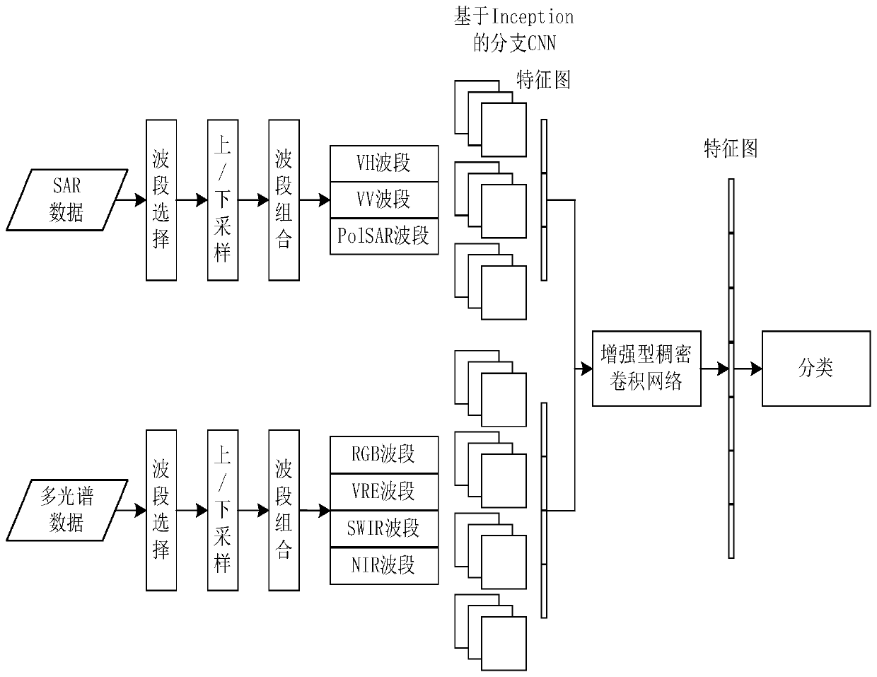
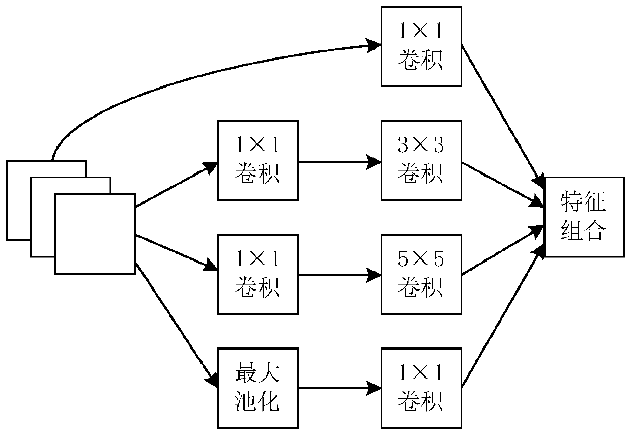
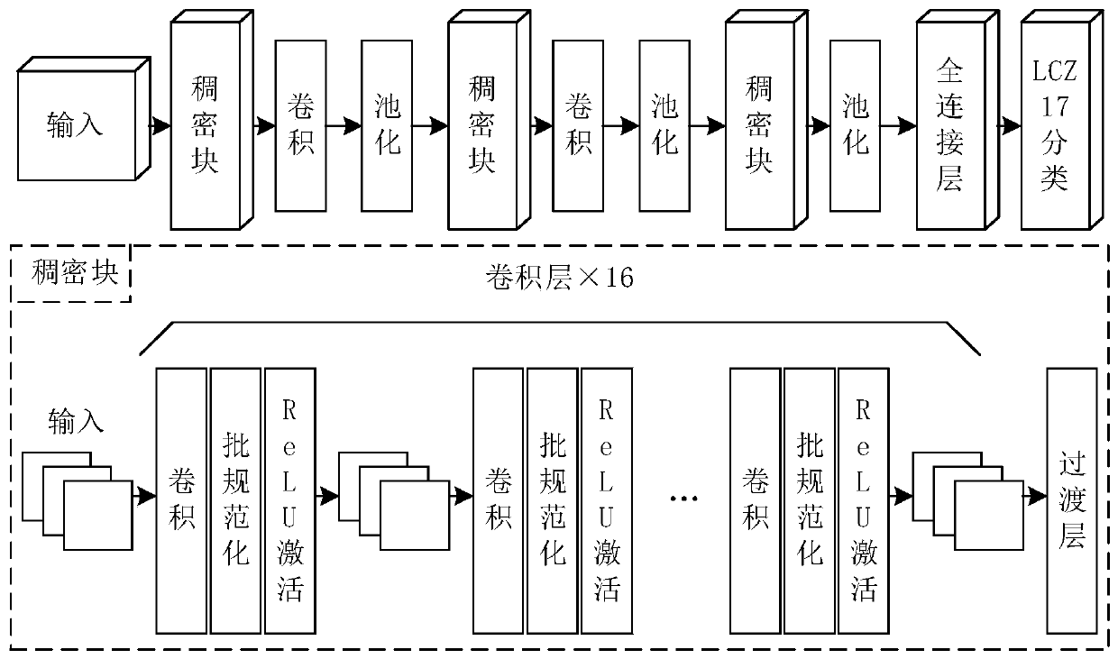
[0028] Such as Figure 1-3 As shown, a local climate region classification structure based on branch CNN using SAR and multispectral remote sensing data, including SAR data preprocessing module, multispectral data preprocessing module, said SAR data preprocessing module, multispectral data preprocessing module Connect with respective corresponding branch CNN modules based on Inception, and the two branch CNN modules based on Inception are all connected with an enhanced dense convolution network, and the enhanced dense convolution network is used to output the local climate area category in turn. The fully connected layer and softmax layer connection;

[0029] During specific implementation, the SAR data preprocessin...


PUM


Abstract

The invention relates to a branch CNN-based local climate region classification structure through using SAR and multispectral remote sensing data. The branch CNN-based local climate region classification structure comprises an SAR data preprocessing module and a multispectral data preprocessing module. The SAR data preprocessing module and the multispectral data preprocessing module are respectively connected with respective corresponding Inception-based branch CNN modules; wherein the two Inception-based branch CNN modules are both connected with an enhanced dense convolutional network, and the enhanced dense convolutional network is sequentially connected with a full connection layer and a softmax layer which are used for outputting local climate region categories. The invention furtherprovides a local climate region classification method using SAR and multispectral remote sensing data based on the branch CNN. According to the method, the integration of SAR and multispectral data can be realized, and the branch CNN can be used for respectively extracting the characteristics of the SAR and multispectral channel data, so that the multi-source remote sensing data is fully utilized,and the problem of local climate region classification based on the remote sensing data is better solved.

Description

technical field [0001] The present invention relates to the field of intelligent processing of satellite remote sensing information, in particular to multi-spectral remote sensing data, synthetic aperture radar (Synthetic Aperture Radar, SAR) data, convolutional neural network (Convolutional Neural Networks, CNN) climate region classification technology, specifically a method based on Branched CNN structure and method for local climate region classification using SAR and multispectral remote sensing data. Background technique [0002] The Local Climate Zone (LCZ) classification was originally used to observe the urban heat island (Urban Heat Island, UHI) metadata communication, and has been widely used in other urban observation-oriented studies, such as population density estimation and economic development detection, It provides key support for research fields such as urban climatology, facility-based planning, and disaster prediction. [0003] At present, there are many ...

Claims


Application Information

Patent Timeline
Patent Type & Authority Applications(China)
IPC IPC(8): G06K9/00G06K9/62G06N3/04
CPCG06V20/194G06V20/13G06N3/045G06F18/24G06F18/253
Inventor 武迪宋华文冯鹏铭
Owner 北京中科千寻科技有限公司
Why Eureka
Try Eureka