Drainage basin map making method for vector graphic file

A vector graphics and map drawing technology, applied in the field of map drawing, can solve the problems of low efficiency and complicated operation of the watershed map drawing process, and achieve the effect of realizing the automation of the whole process.

Active Publication Date: 2020-07-31
SUN YAT SEN UNIV
View PDF5 Cites 2 Cited by
  • Summary
  • Abstract
  • Description
  • Claims
  • Application Information

AI Technical Summary

Problems solved by technology

[0003] The present invention provides a method for making a watershed map oriented to vector graphic files in order to solve the problems of complex operation, low efficiency and dependence on various commercial software in the drawing process of the existing watershed map

Method used


Image

  • Drainage basin map making method for vector graphic file
  • Drainage basin map making method for vector graphic file
  • Drainage basin map making method for vector graphic file

Examples


Embodiment 1

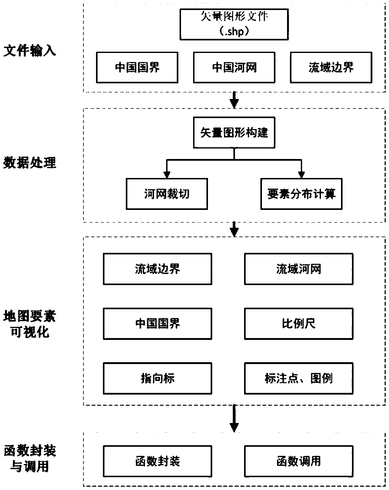
[0060] A method for making watershed maps oriented to vector graphics files, such as figure 1 shown, including the following steps:

[0061] S1. File input: take the vector graphics file (.shp) required for watershed map drawing as input data, use the Reader function in the Python third-party library Shapefile, and read it according to the storage path of the vector graphics file required for watershed map drawing The regional boundary data; the vector graphic files include the vector graphic files of the national boundary of country A, the river network of country A and the boundary of the target watershed;

[0062] S2. Data processing: According to the obtained regional boundary data, extract all the points data of irregular graphic boundaries sequentially, and use the geometry.Polygon and geometry.LineString functions in the Python third-party library Shapely to construct the river network of country A and the target watershed boundary The vector graphics; the points are t...

Embodiment 2

[0094] This embodiment 2 provides an example based on the application of the vector graphic file-oriented watershed map drawing method provided in the embodiment 1 to the watershed drawing in the upper reaches of the Yangtze River in China.

[0095] S1. Store the vector graphics files of China's national boundaries, river networks and target watershed boundaries required for basin mapping in the same folder, define variables path_China, path_rivernet and path_bssin respectively and store the corresponding paths, read through the Reader function in Shapefile Get these files.

[0096] S2. Use the Python third-party library Shapely for data processing, including river network cropping and calculation of basin map element distribution:

[0097] ①Use the geometry.Polygon and geometry.LineString functions in Shapely to construct the vector graphics of the watershed boundary and the Chinese river network;

[0098] ②Using the for loop in Python, read each vector graphic object in the...


PUM


Abstract

The invention discloses a drainage basin map making method for a vector graphic file, which comprises the following steps of: reading region boundary data in a drainage basin map by taking a vector graphic file required for drawing the drainage basin map as input data; according to the obtained region boundary data, performing spatial analysis on the region boundary data so as to perform river network cutting and drainage basin map element distribution calculation; visualizing the drainage basin map elements, and storing the drawn drainage basin map to a specified path; and packaging the drawing process into class functions, and calling the class functions to draw a basin map. By designing the visualization class function for the vector graphic file, the needed vector graphic file is automatically processed, in the drawing process of the basin map, automatic calculation is conducted, element distribution positions are distributed, manual adjustment is not needed, and therefore full-process automation of basin map drawing is achieved.

Description

technical field [0001] The invention relates to the technical field of map drawing, in particular to a method for making a watershed map oriented to vector graphic files. Background technique [0002] A map is a graphic or image representing the earth with a certain mathematical basis, symbol system, and text marks, and is a carrier of geographic information. The watershed map is the most direct tool for hydrometeorological workers to understand the distribution of a specific watershed and its water system, and it is an effective way for in-depth regional research. However, in actual work, the production of watershed maps usually relies on various commercial software, which involves copyright issues of commercial software and complex software operations. Map drawing also requires cross-platform operations, and the operation of the drawing process is complicated. Watershed map drawing low efficiency. Contents of the invention [0003] The invention provides a method for m...

Claims


Application Information

Patent Timeline
Patent Type & Authority Applications(China)
IPC IPC(8): G06F16/29G06T11/20
CPCG06F16/29G06T11/206
Inventor 赵铜铁钢黄泽青
Owner SUN YAT SEN UNIV
Why Eureka
Try Eureka