
Vehicle measurement method based on map image

A vehicle measurement and image technology, applied in the field of vehicle measurement based on map images, can solve the problems of inapplicability, affecting traffic, and inability to use in places with insufficient manpower, so as to facilitate subsequent development, improve robustness, and reduce misjudgment. rate effect

Active Publication Date: 2020-07-31
清华大学苏州汽车研究院(吴江) +1
View PDF6 Cites 2 Cited by
  • Summary
  • Abstract
  • Description
  • Claims
  • Application Information

AI Technical Summary

Problems solved by technology

Ground sense coil detection has the advantages of low price and fast detection speed, but it will cause great damage to the road, a large amount of preliminary engineering, and affect traffic; traditional camera calibration often obtains multiple pictures taken from different angles of the scene artificially, for some distant, It is not applicable to places with insufficient manpower. Some other improved camera calibration uses some special traffic signs and graphics composed of special buildings for camera calibration, but once the video does not have these special markings and graphics, it cannot be used. method

Method used


Image

  • Vehicle measurement method based on map image
  • Vehicle measurement method based on map image
  • Vehicle measurement method based on map image

Examples


Embodiment

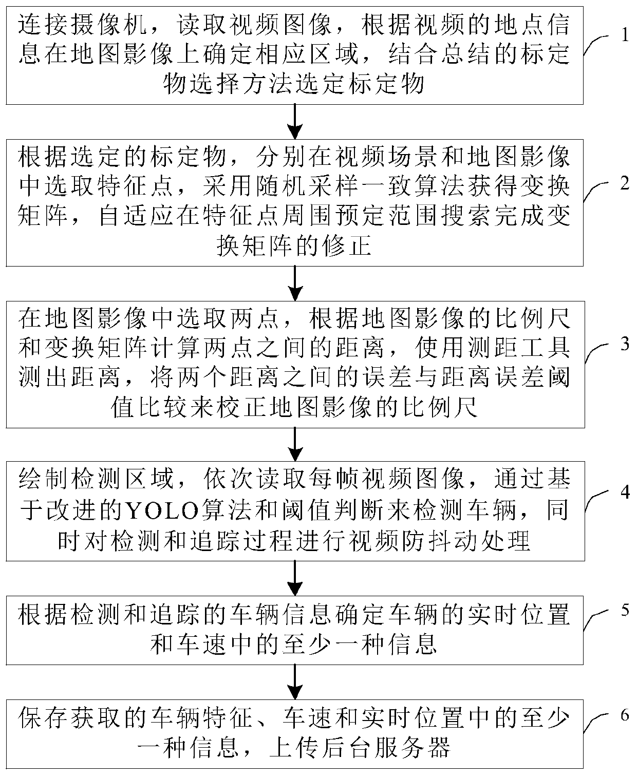
[0043] Embodiment: This application provides a vehicle measurement method based on map images, combined with reference Figure 1 to Figure 3 , this method uses map images to calibrate video, and summarizes a set of calibration methods based on map images, including the selection experience of calibration objects and scale correction methods, which can quickly resume the transformation relationship between video scenes and map images, and can include the following steps :

[0044] Step 1. Connect the camera, read the video image, determine the corresponding area on the map image according to the location information of the video, and select the calibration object based on the summarized calibration object selection method.

[0045] Optionally, determining the corresponding area on the map image according to the location information of the video in step 1 may include:

[0046] Select the area corresponding to the video scene on the map according to the video name or the GPS inf...


PUM


Abstract

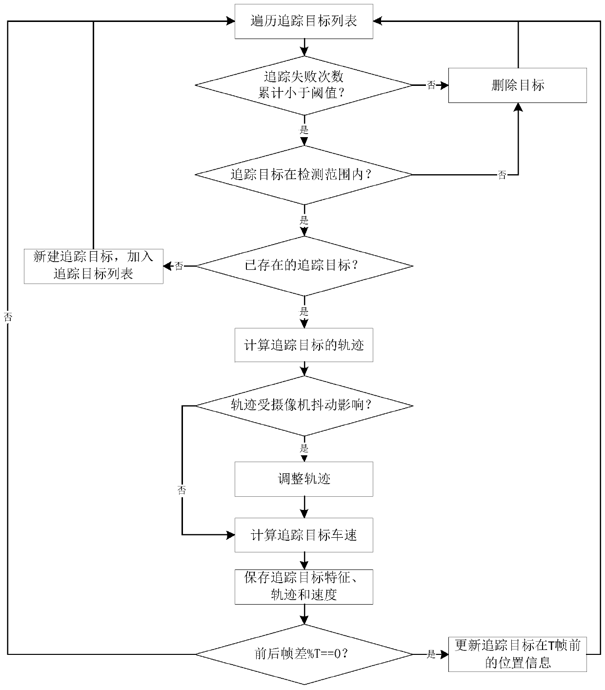
The invention discloses a vehicle measurement method based on a map image, and the method comprises the steps: connecting a camera, determining a corresponding region on the map image according to thelocation information of a video image, and selecting a calibration object through combining with the summarized selection experience of the calibration object; respectively selecting feature points of the calibration object in the video scene and the map image, and adaptively correcting the transformation matrix; correcting the map image scale according to the calculated distance and the distancemeasured by the distance measuring tool; detecting and tracking a vehicle through an improved YOLO algorithm and a video jitter processing algorithm, and correcting the real-time position and speed of the vehicle; and finally, storing the vehicle characteristics, the vehicle speed and the real-time position, and uploading to a background server. According to the method, the camera is combined with the map image, camera calibration can be completed without a special calibration object during calibration, the method is simple and rapid, excessive manpower and material resources do not need to be consumed, the misjudgment rate is reduced by combining the improved YOLO algorithm and the video jitter processing algorithm, and vehicle information is measured more accurately.

Description

technical field [0001] The invention belongs to the technical field of image processing and relates to a vehicle measurement method based on map images. Background technique [0002] As an all-weather reliable monitoring, video surveillance is more and more recognized by the society. It can provide users with more accurate characteristics of security threats, reduce the probability of false positives and false positives, and enable security departments to have enough time to detect potential threats. prepare for the threat. [0003] The current methods of measuring speed mainly include methods based on ground induction coils and methods based on camera calibration. Ground sense coil detection has the advantages of low price and fast detection speed, but it will cause great damage to the road, a large amount of preliminary engineering, and affect traffic; traditional camera calibration often obtains multiple pictures taken from different angles of the scene artificially, for...

Claims


Application Information

Patent Timeline
Patent Type & Authority Applications(China)
IPC IPC(8): G08G1/052G08G1/054G08G1/08
CPCG08G1/052G08G1/054G08G1/08
Inventor 路萍王宝宗顾会建史宏涛章烨
Owner 清华大学苏州汽车研究院(吴江)
Learn More