Building detection method based on laser radar point cloud and near-infrared image

A technology of laser radar and detection method, which is applied in measurement devices, re-radiation of electromagnetic waves, character and pattern recognition, etc., can solve the problems of high misclassification rate, lack of high-precision detection methods at the scanning point level of buildings, etc., and achieves a degree of automation High and improve the effect of segmentation accuracy

Active Publication Date: 2020-08-04
AEROSPACE INFORMATION RES INST CAS
View PDF7 Cites 3 Cited by
  • Summary
  • Abstract
  • Description
  • Claims
  • Application Information

AI Technical Summary

Problems solved by technology

[0006] The purpose of the present invention is to provide a building detection method based on lidar point cloud and near-infrared images to solve the problem of high misclassification rate between buildings and trees in areas with high vegetation coverage and lack of building scanning in the prior art Point-level high-precision detection methods can effectively improve the detection accuracy of buildings

Method used


Image

  • Building detection method based on laser radar point cloud and near-infrared image
  • Building detection method based on laser radar point cloud and near-infrared image
  • Building detection method based on laser radar point cloud and near-infrared image

Examples


Embodiment Construction

[0035] The following will clearly and completely describe the technical solutions in the embodiments of the present invention with reference to the accompanying drawings in the embodiments of the present invention. Obviously, the described embodiments are only some, not all, embodiments of the present invention. Based on the embodiments of the present invention, all other embodiments obtained by persons of ordinary skill in the art without making creative efforts belong to the protection scope of the present invention.

[0036] In order to make the above objects, features and advantages of the present invention more comprehensible, the present invention will be further described in detail below in conjunction with the accompanying drawings and specific embodiments.

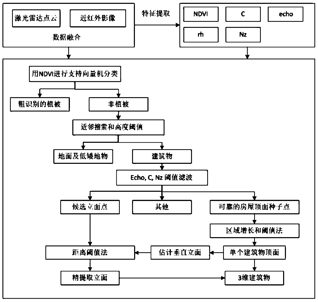
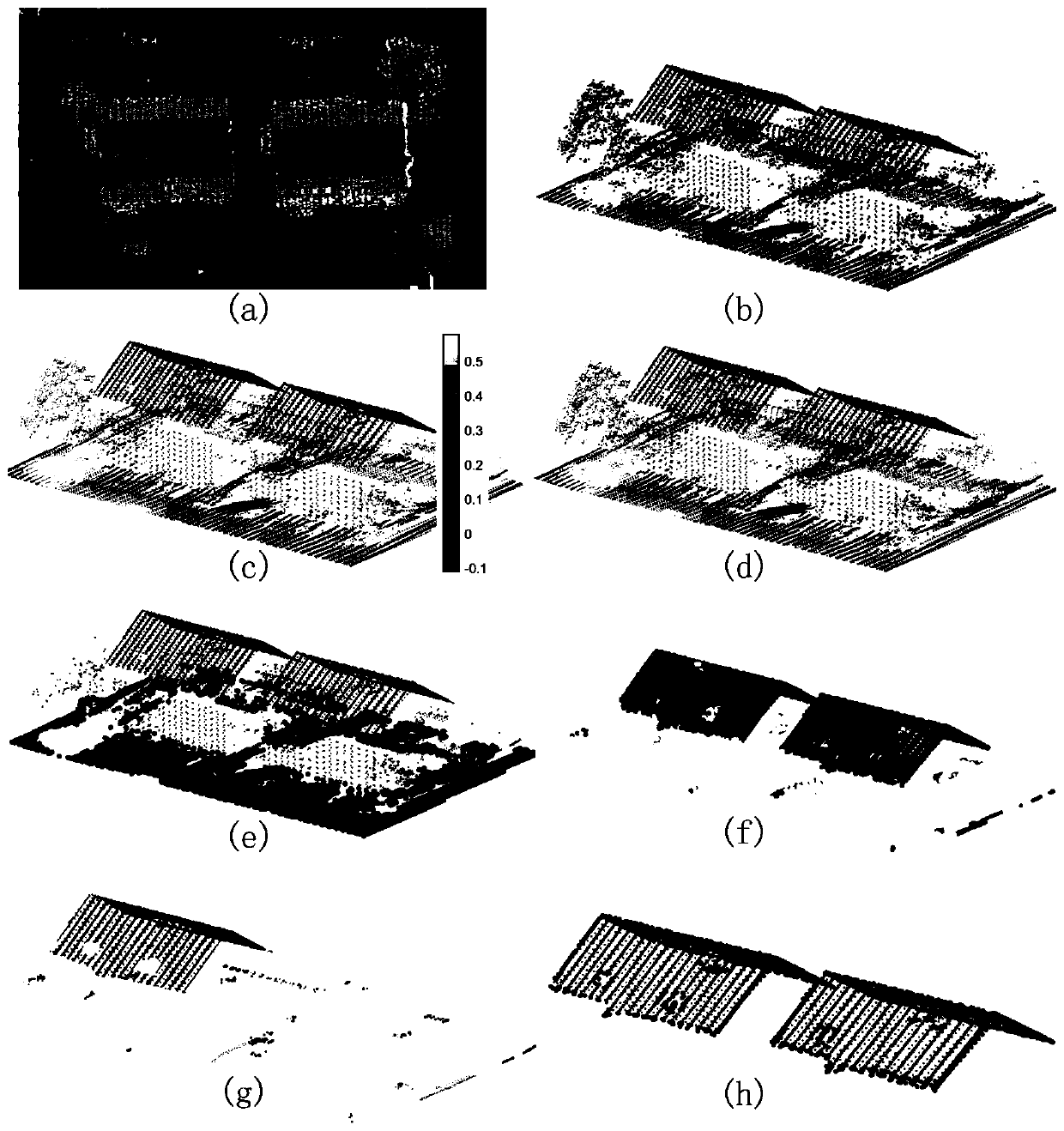
[0037] refer to figure 1 As shown, this embodiment provides a building detection method based on lidar point cloud and near-infrared images, including the following steps:

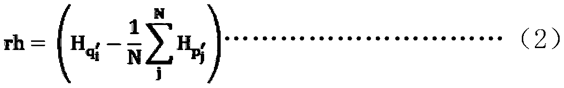
[0038] Step S1. Acquiring orthophotos ...


PUM


Abstract

The invention discloses a building detection method based on a laser radar point cloud and a near-infrared image. The method comprises the steps: obtaining an ortho-image with a near-infrared band andthe laser radar point cloud, and carrying out the registration and fusion of the ortho-image and the laser radar point cloud; calculating a normalized difference vegetation index NDVI of each laser point after fusion, and completing vegetation identification based on the NDVI and a support vector machine classifier; as for non-vegetation laser points, completing building recognition through a neighbor search algorithm and a height threshold value; as for the building laser points, extracting roof seed points and candidate facade points, and obtaining a roof point group based on a single building according to the roof seed points; estimating the vertical facade of the building based on the roof point group of each building; estimating a vertical facade based on the candidate facade points,and performing fine extraction of the facade points; and completing the detection of the three-dimensional building through the roof points and the facade points obtained through fine extraction. Thedetection precision of the building is effectively improved, and the high detail level of the building model can be ensured.

Description

technical field [0001] The invention relates to the technical field of three-dimensional extraction of remote sensing ground objects, in particular to a building detection method based on laser radar point clouds and near-infrared images. Background technique [0002] Building detection using remote sensing data has good applications in various fields such as urban planning, real estate and land use analysis. Conceptually, building detection is a classification problem that requires separating buildings from other objects such as vehicles, ground (roads, lawns) and vegetation (trees and shrubs). Existing building detection algorithms can be divided into three categories according to the different input data. [0003] The first is an aerial image-based method, which uses pixel-based and object-based image segmentation methods to extract buildings. Heterogeneous pixel-based methods, whether using supervised or unsupervised learning, have the advantage of always low complexit...

Claims


Application Information

Patent Timeline
Patent Type & Authority Applications(China)
IPC IPC(8): G01S17/86G01S17/89G06K9/00G06K9/62
CPCG01S17/86G01S17/89G06V20/194G06V20/176G06F18/2411
Inventor 李毅戴玉成龚建华孙麇周洁萍李文航殷兵晓
Owner AEROSPACE INFORMATION RES INST CAS
Why Eureka
Try Eureka