Monitoring method for land subsidence

A land subsidence and ground technology, applied in measurement devices, use of re-radiation, radio wave measurement systems, etc., can solve the problems of large input manpower, weather influence, long field operation time, etc., to improve efficiency, reduce labor costs, The effect of comprehensive identification

Active Publication Date: 2020-08-21
江苏中煤地质工程研究院有限公司
View PDF5 Cites 4 Cited by
  • Summary
  • Abstract
  • Description
  • Claims
  • Application Information

AI Technical Summary

Problems solved by technology

[0003] The land subsidence monitoring project is based on the accuracy of the national second-class leveling survey, using the urban surveying method, after selecting points, burying rocks, high-precision leveling surveys, and data adjustment calculations, and then obtaining the annual height difference of the monitoring points, so as to analyze the land subsidence in the survey area Development trend, with disadvantages such as long field work time, large investment of manpower, and being affected by weather

Method used


Image

  • Monitoring method for land subsidence

Examples


Embodiment Construction

[0029] The following will clearly and completely describe the technical solutions in the embodiments of the present invention with reference to the accompanying drawings in the embodiments of the present invention. Obviously, the described embodiments are only some, not all, embodiments of the present invention. Based on the embodiments of the present invention, all other embodiments obtained by persons of ordinary skill in the art without making creative efforts belong to the protection scope of the present invention.

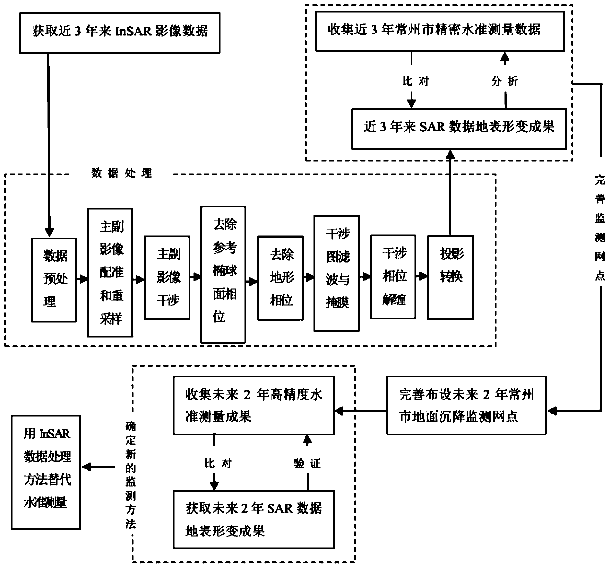
[0030] A monitoring method for land subsidence, comprising the steps of:

[0031] Step 1: SAR data selection, preparation of external DEM and precise orbit data;

[0032] 1.1. When selecting SAR images, we adopt the method of one scene per month;

[0033] 1.2. Remove the interferometric phase component caused by terrain undulations, and prepare external DEM data for the corresponding area;

[0034] 1.3. Accurate orbit data is acquired together with SAR image...


PUM


Abstract

The invention relates to a land subsidence measurement technology, in particular to a monitoring method for land subsidence. The method comprises the following steps of: 1, SAR data selection, and preparation of external DEM and precision orbit data; 1.1, removing an interference phase component caused by topographic relief, and preparing external DEM data of a corresponding region; 1.2, acquiringprecision orbit data along with an SAR image; 2, processing of the SAR data; 2.1, data preprocessing, thus obtaining an SAR image which is focused data in a single-look complex format *.SLC, whereinthe SLC data comprises echo intensity and time delay information of SAR signals in each resolution unit on the ground; 3, data comparing and analyzing; 3.1, comparing an SAR data surface deformation result with a precise leveling result; and 4, determination of a new method: 4.1, supplementing field on-site monitoring points according to an InSAR image data interference analysis result.

Description

technical field [0001] The invention relates to land subsidence measurement technology, in particular to a monitoring method for land subsidence. Background technique [0002] InSAR (Synthetic Aperture Radar Interferometry) technology uses microwave synthetic aperture radar (SAR) imagery (SAR) data to repeatedly observe the surface of the microwave (1 mm to 1 m) phase difference to calculate the surface deformation, and the accuracy can reach the millimeter level. InSAR technology is recognized as an efficient means of surveying and monitoring surface deformation. It can observe surface deformation in a large scale, retrospectively, and non-contact, and has the advantages of "a distance of a thousand miles, a perception of a millimeter", "regardless of black and white, rain or shine". [0003] The land subsidence monitoring project is based on the accuracy of the national second-class leveling survey, using the urban surveying method, after selecting points, burying rocks, ...

Claims


Application Information

Patent Timeline
Patent Type & Authority Applications(China)
IPC IPC(8): G01S13/88G01S13/90
CPCG01S13/882G01S13/9023
Inventor 李红慧侯占东钱正春黄小海梁磊白晓慧许丹青郝柏园
Owner 江苏中煤地质工程研究院有限公司
Why Eureka
Try Eureka