A Calculation Method of Four Survey Lines of Any Type of Tunnel Based on Original Image in Tunnel
What is AI technical title?
AI technical title is built by PatSnap AI team. It summarizes the technical point description of the patent document.
A technology of any type and calculation method, applied in the fields of calculation, computer components, image analysis, etc., can solve the problems of limited accuracy and roughness, and achieve the effect of fast image generation, high reusability, and high calculation accuracy
Active Publication Date: 2022-06-17
CAPITAL NORMAL UNIVERSITY
View PDF6 Cites 0 Cited by
Summary
Abstract
Description
Claims
Application Information
AI Technical Summary
This helps you quickly interpret patents by identifying the three key elements:
Problems solved by technology
Method used
Benefits of technology
Problems solved by technology
The above-mentioned patents have limited accuracy in the analysis of tunnel structural changes, and can only make roughly rough judgments, and their applications have certain limitations.
Method used
Image
Click on the blue label to locate the original text in one second.
Reading with bidirectional positioning of images and text.
Examples
Embodiment 1
[0068] A method for calculating four measuring lines of any type of tunnel based on original images in a tunnel, comprising the following steps:
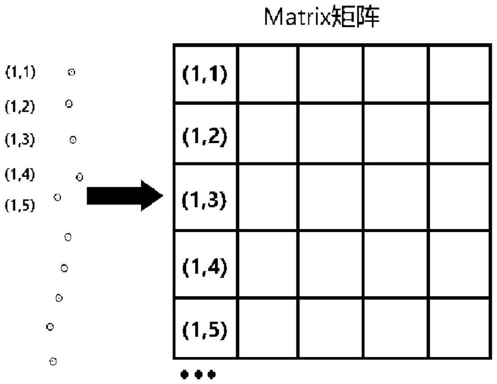
[0069] S1. Arrange marking points.
[0070] Among them, the layout of marker points includes the following steps:
[0071] 101. Set up the total station directly above the track surface to ensure that the centering position is also on the track surface. At a distance of 20m from the total station, select the same point on the track surface as the centering position of the total station to mark;
[0072] 102. Aim the total station at the marked point on the track surface. At this time, set the total station to zero degrees, rotate the total station horizontally by 90°, and tighten the horizontal brake knob, so that the total station can only be rotated within the section. ;
[0073] 103. Using the method of step 102, select five points on different segments in the same section, and paste the reflective sheet, which can be reused. ...
Embodiment 2
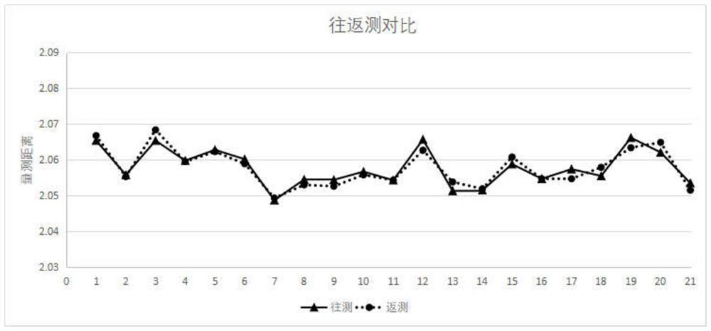
[0114] Based on the above-mentioned embodiment 1, the above-mentioned four-line calculation method is adopted, and the total station measurement data is used for the comparison measurement, and the same section of tunnel is carried out round-trip measurement, and the comparison data is as shown in Table 1:
[0117] It can be seen from Table 1 that the adopted chord calculation method has high accuracy, and the round-trip measurement accuracy and the comparison accuracy of the total station are both within 3mm, which meets the needs of tunnel deformation monitoring.
[0118] as attached image ...
PUM
Abstract
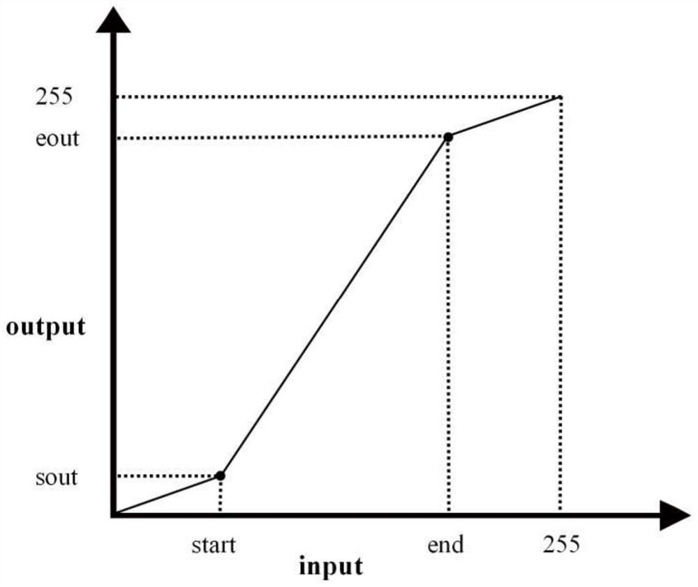
The present invention relates to a method for calculating the four measuring lines of any type of tunnel based on original images in the tunnel, comprising the following steps: laying out marker points; collecting point cloud data and establishing point cloud slice indexes; generating original images of tunnels; The algorithm performs segmented linear stretch processing on the image; identifies the center of the reflective sheet; calculates the length of the chord; the invention makes up for the shortcomings of monitoring by fitting the center of the section or based on the orthophoto image, and the image generation speed is fast, which is suitable for mining methods and shields The cross-section constructed by construction method has no restrictions on the shape of the cross-section, and is not limited by the shape of the tunnel and the construction method. It is suitable for the chord calculation of any type of tunnel, and the calculation accuracy is high, which greatly facilitates the needs of tunnel deformation monitoring.
Description
technical field [0001] The invention relates to the technical field of point cloud data processing, in particular to a method for calculating four measuring lines of any type of tunnel based on original images in a tunnel. Background technique [0002] In 2019, a total of 40 cities in mainland China opened 6,730.27 kilometers of urban rail transit operation lines. In 2019, five new urban rail transit cities, Wenzhou, Jinan, Changzhou, Xuzhou, and Hohhot, were added in mainland China; another 27 cities added new urban rail transit lines. The line (section) was put into operation, and the newly added operating line was 968.77 kilometers long, setting a new record high. With the rapid development of urban subways and high-speed railways, the safety during tunnel construction and operation cannot be underestimated, and regular monitoring of diseases in tunnels is essential. Especially in tunnel monitoring during operation, operations can often only be carried out during the sky...
Claims
Application Information
Patent Timeline
Application Date:The date an application was filed.
Publication Date:The date a patent or application was officially published.
First Publication Date:The earliest publication date of a patent with the same application number.
Issue Date:Publication date of the patent grant document.
PCT Entry Date:The Entry date of PCT National Phase.
Estimated Expiry Date:The statutory expiry date of a patent right according to the Patent Law, and it is the longest term of protection that the patent right can achieve without the termination of the patent right due to other reasons(Term extension factor has been taken into account ).
Invalid Date:Actual expiry date is based on effective date or publication date of legal transaction data of invalid patent.

