Intelligent system for automatically acquiring instantaneous erosion and deposition topographic data near bridge underwater foundation and surveying and mapping method thereof

A technology for underwater foundation and terrain data, which is applied in radio wave measurement systems, measurement devices, and re-radiation of sound waves to achieve the effects of convenient operation, convenient transportation and maintenance, and simple structure.

Inactive Publication Date: 2020-09-22
江苏航运职业技术学院
View PDF0 Cites 0 Cited by
  • Summary
  • Abstract
  • Description
  • Claims
  • Application Information

AI Technical Summary

Problems solved by technology

[0003] The purpose of the present invention is to provide a simple structure, convenient operation, high-precision and high-efficiency instantaneous scouring and silting terrain data automatic acquisition intelligent system and surveying method for the underwater foundation of bridges, so as to solve the problem of scouring and silting terrain surveying and mapping equipment near the existing bridge underwater foundation. Disadvantages of Surveying and Mapping Operation Method

Method used


Image

  • Intelligent system for automatically acquiring instantaneous erosion and deposition topographic data near bridge underwater foundation and surveying and mapping method thereof
  • Intelligent system for automatically acquiring instantaneous erosion and deposition topographic data near bridge underwater foundation and surveying and mapping method thereof
  • Intelligent system for automatically acquiring instantaneous erosion and deposition topographic data near bridge underwater foundation and surveying and mapping method thereof

Examples


Embodiment Construction

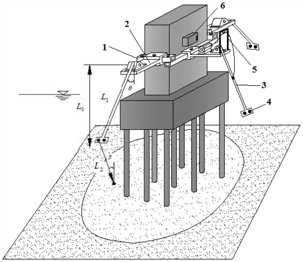
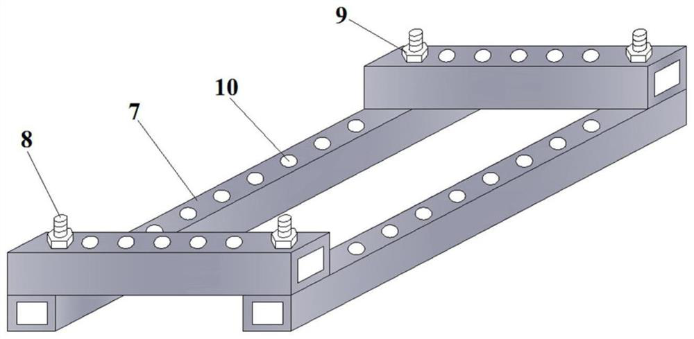
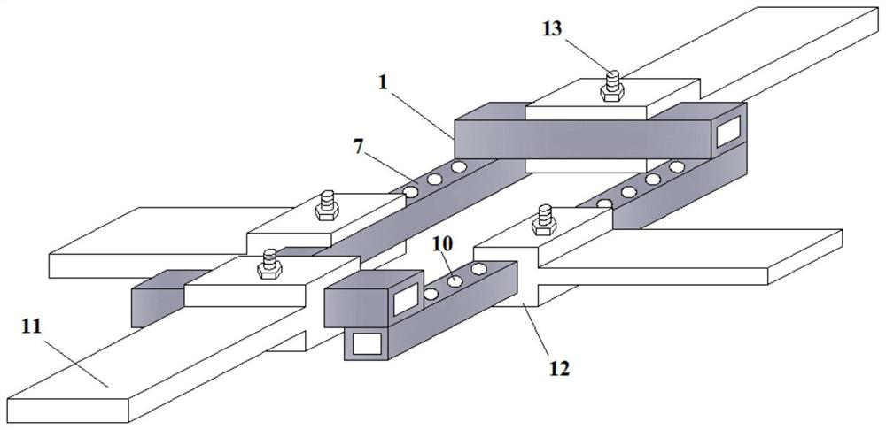
[0030] In order to make the technical problems, technical solutions and beneficial effects to be solved by the present invention clearer, the present invention will be further described in detail below in conjunction with the accompanying drawings and embodiments. It should be understood that the specific embodiments described here are only used to explain the present invention, not to limit the present invention.

[0031]It should be noted that when an element is referred to as being “fixed”, “installed”, “connected” or “disposed” with another element, it may be directly on the other element or indirectly on the other element. It is to be understood that the terms "upper", "lower", "front", "rear", "left", "right", "vertical", "horizontal", "top", "bottom", "inner" The orientation or positional relationship indicated by , "outside", etc. is based on the orientation or positional relationship shown in the drawings, and is only for the convenience of describing the present inve...


PUM


Abstract

The invention provides an intelligent system for automatically acquiring instantaneous erosion and deposition topographic data near a bridge underwater foundation and a surveying and mapping method thereof. A supporting platform is fixed to the side wall, located above the free water surface, of the pier. An operation platform is fixed to the outer side of the supporting platform. A transmission device is connected with a surveying and mapping device and then is mounted on a fixed hinge support on the operating platform; a lifting mechanism on the operation platform is connected with the transmission device through a sling and a lantern ring; the terminal computer issues an instruction based on the connection to remotely control the lifting mechanism to adjust the spatial position of the surveying and mapping device and control a stepping motor on the transmission device to drive the long straight steel shaft to rotate; the long straight steel shaft drives the built-in circular pipe torotate through the worm and the concentric turbine; an ultrasonic transducer fixed to the side wall of the built-in circular pipe scans the three-dimensional underwater terrain, then the collected three-dimensional terrain data are wirelessly transmitted to the terminal computer, and then any instantaneous three-dimensional terrain in the scouring and silting development process of the peripheryof the bridge underwater foundation is drawn through a software platform.

Description

technical field [0001] The invention belongs to the technical field of intelligent surveying and mapping of local scouring topography for wading engineering, and in particular relates to an intelligent system for automatically acquiring instantaneous scouring and silting terrain data near the underwater foundation of a bridge. Terrain data is automatically acquired by the surveying and mapping method of the intelligent system. Background technique [0002] With the rapid development of transportation, a large number of wading projects such as bridges across waters have begun to be built, and the number is increasing and the volume is also increasing. The appearance of the bridge disturbs the original normal river flow, which will form a complex three-dimensional vortex system and high-intensity water turbulence, and then form a large three-dimensional local scour pit around the underwater foundation of the bridge. The growth of the three-dimensional spatial scale of local s...

Claims


Application Information

Patent Timeline
Patent Type & Authority Applications(China)
IPC IPC(8): G01S15/89G01S7/521
CPCG01S7/521G01S15/89
Inventor 倪飞戴雨陈亚东史誉州李胜永房世龙朱庆王浩丞陈皓文史学娇陈瑶李银秀
Owner 江苏航运职业技术学院
Why Eureka
Try Eureka