Remote sensing image water area automatic extraction method and system based on deep learning

A remote sensing image and deep learning technology, applied in the field of geographic information, can solve the problem of time-consuming and labor-intensive methods of water extraction from remote sensing images

Pending Publication Date: 2020-10-13
CHINA UNIV OF GEOSCIENCES (WUHAN)
View PDF5 Cites 24 Cited by
  • Summary
  • Abstract
  • Description
  • Claims
  • Application Information

AI Technical Summary

Problems solved by technology

[0004] The technical problem to be solved by the present invention is to provide a method and system for automatic extraction of remote sensing image water area

Method used


Image

  • Remote sensing image water area automatic extraction method and system based on deep learning
  • Remote sensing image water area automatic extraction method and system based on deep learning
  • Remote sensing image water area automatic extraction method and system based on deep learning

Examples


specific Embodiment approach 1

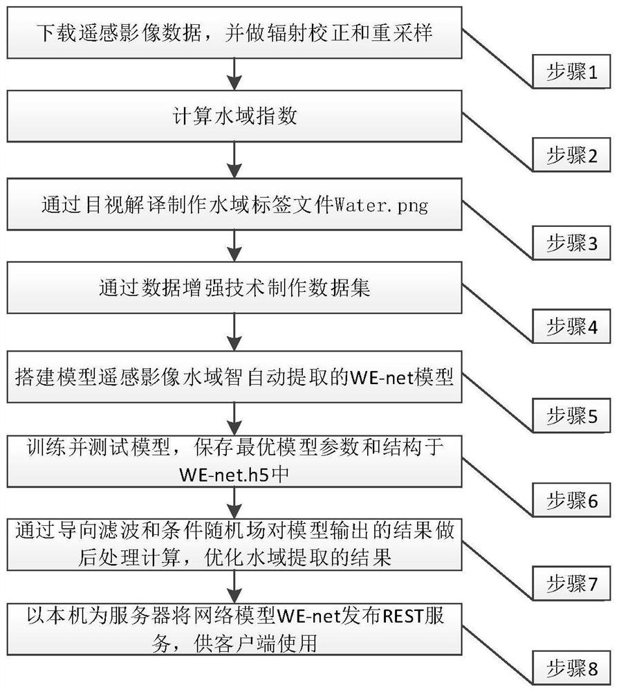
[0014] Specific implementation mode 1. Combination figure 1 Describe this embodiment, the deep learning-based remote sensing image waters automatic extraction method described in this embodiment, it comprises the following steps:

[0015] Step (1), download the Sentinel-2 data (S2A MSIL1C) of the European Space Agency, open the CMD console, perform atmospheric correction through the command L2A_Process in Sen2cor, and resample the corrected data through the SNAP software (raster->geometric operations->resampling) to obtain the data of each band of remote sensing images that can be processed by ENVI 5.3 software.

[0016] Step (2), the normalized difference water index NDWI (NDWI=(Green-NIR) / (Green+NIR)), the improved water index model NDWI3 (NDWI3= (NIR-SWIR-2) / (NIR+SWIR-2)), improved normalized difference water index MNDWI (MNDWI=(Green-SWIR-1) / (Green+SWIR-1)), enhanced water index EWI (EWI=(Green-NIR-SWIR-1) / (Green+NIR+SWIR-1)), Normalized Difference Vegetation Cover Index...

specific Embodiment approach 2

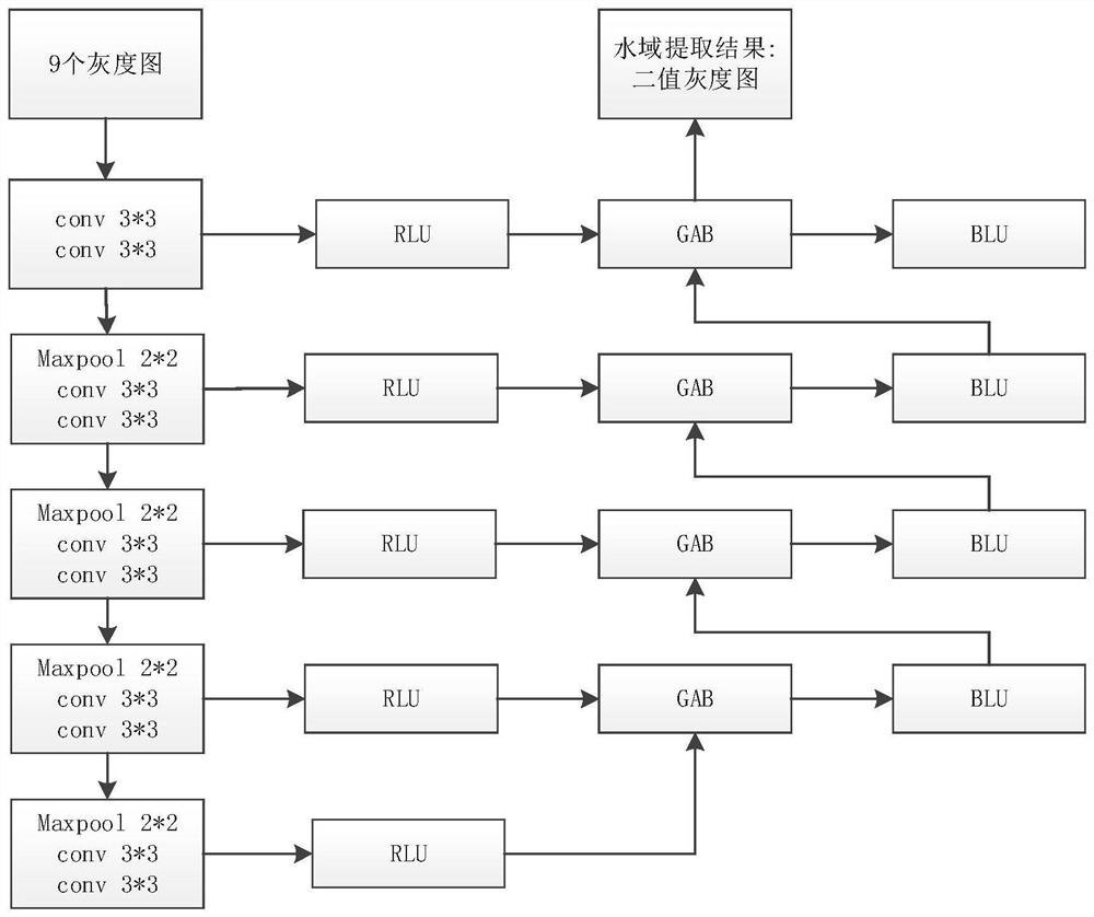
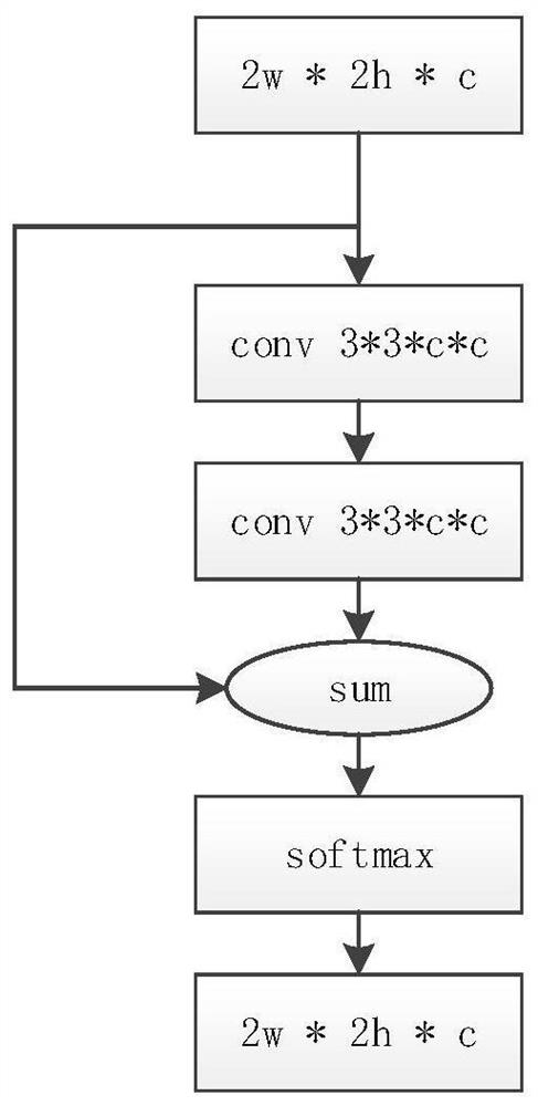
[0023] Specific embodiment two, combine figure 2 , image 3 , Figure 4 and Figure 5 Describe this embodiment, the remote sensing image water area segmentation model WE-Net described in this embodiment, it comprises the following steps:

[0024] Encoding step: In the encoding stage, the feature information of the water area is extracted through convolution and pooling. In the encoding stage, 12 grayscale images are used as input data, and the feature map is obtained by convolving and fusing the input data. Every time the feature map passes through a pooling layer, it is a scale. There are 5 scales including the scale of the original image, namely 256*256*32 , 128*128*64, 64*64*128, 32*32*256, and 16*16*512; after the pooling layer, the size of the feature map is halved and the number of channels is doubled, and then two convolutional neural networks The network extracts the water feature information of the image.

[0025] Decoding step: In the decoding stage, the image ...


PUM


Abstract

The invention provides a remote sensing image water area automatic extraction method and system based on deep learning. The method comprises the following steps: preprocessing remote sensing image data, obtaining different water area indexes through waveband operation, obtaining prior feature information extracted from a water area, fusing the remote sensing image data, Google map tile data and the like to realize multi-source feature information fusion, and then constructing a data set through visual interpretation and vectorization; training, verifying and testing a semantic segmentation model WE-Net built by the convolutional neural network; and calling a remote sensing image water area segmentation model WE-Net to realize automatic classification of the water area, and outputting a binary grayscale image which is a classification and extraction result. The method has the advantages that a water area in a research area can be extracted by calling a remote sensing image water area segmentation model, manual visual interpretation can be replaced, manpower and material resources are saved, and auxiliary technical support is provided for updating of a high-precision image map, including lake area change detection, water system change and the like.

Description

technical field [0001] The present invention relates to the field of geographic information, in particular to the field of surface waters, and in particular to a method and system for automatically extracting waters from remote sensing images based on deep learning. Background technique [0002] Rivers and lakes are the most common manifestations of surface waters, which often increase or decrease due to changes in factors such as climate change, land use, and crustal activity. , River supervision and pollution control and other ecological issues are of great significance. With the continuous development of remote sensing technology, remote sensing images have gradually become an effective means of extracting changes in surface waters. Traditional remote sensing image water body extraction methods often use manual visual interpretation, which requires manual drawing. Although the accuracy is high, it is time-consuming and laborious. In addition, both the single-band thresh...

Claims


Application Information

Patent Timeline
IPC IPC(8): G06K9/00G06K9/34G06K9/62G06N3/04
CPCG06V20/13G06V10/267G06N3/045G06F18/24G06F18/253Y02A90/30
Inventor 李春风余仲阳王涛郭明强
Owner CHINA UNIV OF GEOSCIENCES (WUHAN)
Why Eureka
Try Eureka