GNSS and gyroscope fused high-precision geological disaster monitoring device

A technology for geological disasters and monitoring devices, applied in measurement devices, navigation through velocity/acceleration measurement, instruments, etc., can solve problems such as inability to ensure the continuity of positioning services and slow deformation of geological bodies

Pending Publication Date: 2020-10-16
景麒实业(湖南)有限公司
View PDF1 Cites 2 Cited by
  • Summary
  • Abstract
  • Description
  • Claims
  • Application Information

AI Technical Summary

Problems solved by technology

One of the most basic and key aspects of Beidou’s high-precision geological disaster monitoring is the perception and data collection of on-site conditions. Rainfall is closely related, and there is no mains access at the monitoring site. In the initial stage, the positioning accuracy of the antenna needs to be verified. The document of Chinese Patent Application Publication No. CN103235328A discloses a method of GNSS and MEMS integrated navigation, combining GNSS and MEMS Accelerometer and gyroscope data can improve the accuracy of integrated

Method used


Image

  • GNSS and gyroscope fused high-precision geological disaster monitoring device
  • GNSS and gyroscope fused high-precision geological disaster monitoring device
  • GNSS and gyroscope fused high-precision geological disaster monitoring device

Examples


Embodiment 1

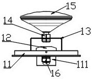
[0026] Embodiment 1: as attached Figure 1~4 As shown, it is a high-precision geological disaster monitoring device integrated with GNSS and gyroscope, including: a monitoring component 1, and the monitoring component 1 includes: an installation base plate 11, and a gyroscope 12 is fixedly installed in the installation base plate 11, and the The gyroscope 12 is a non-sMD nine-axis gyroscope. A bow-shaped mounting bracket 13 is arranged above the gyroscope 12. The center of the upper part of the mounting bracket 13 is fastened to the GNSS antenna 15 through a mounting bolt 14. The mounting base plate 11 A circuit board is also fixedly installed inside, the circuit board is provided with an OEM board and a MEMS accelerometer, the GNSS antenna 15 is connected to the OEM board, and the OEM board receives the positioning information of the satellite navigation system through the GNSS antenna 15, so Several connectors are arranged on the circuit board, the gyroscope 12 is connected ...

Embodiment 2

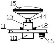
[0027] Embodiment 2: as attached Figure 5 As shown, it is a portable GNSS and gyroscope integrated high-precision geological disaster monitoring device, including: a monitoring component 1, the monitoring component 1 adopts the structure in Embodiment 1, and the monitoring component 1 is connected through a connecting threaded hole 112 Can rotate on the ball head 21 on the ball head 21, the bottom of the ball head 21 is installed on the slide rail 22 and can slide left and right along the slide rail 22, the slide rail 22 is installed on the mounting platform of the tripod 24, The installation platform of the tripod 24 has a handle 23 that can adjust the rotation and tilt of the installation platform.

Embodiment 3

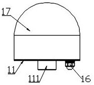
[0028] Embodiment 3: as attached Figure 6~7As shown, it is a high-precision geological disaster monitoring device integrated with fixed GNSS and gyroscope, including: a monitoring component 1, the monitoring component 1 adopts the structure in Embodiment 1, and the monitoring component 1 is installed on the column 31 , the column 31 is a hollow tubular structure inside, the connecting boss 111 and the cooling hole 116 are placed in the hollow tubular structure of the column 31, the waterproof joint 16 is placed outside the column, and the monitoring assembly 1 passes through the installation hole 115 is installed on the column 31, a waterproof sealing ring is added in the installation groove 114 of the waterproof sealing ring and aligned with the pipe wall of the column 31, the installation method of the monitoring component 1 is to first install the attached figure 1 and 2 The part of the structure shown is then installed with a glass fiber reinforced plastic cover 17, and ...


PUM


Abstract

The invention provides a GNSS and gyroscope fused high-precision geological disaster monitoring device. The device comprises: a monitoring assembly. The monitoring assembly comprises: a monitoring unit, a gyroscope is fixedly mounted in the mounting bottom plate, a mounting bracket is arranged above the gyroscope, the center of the upper part of the mounting bracket is fixedly connected with a GNSS antenna, a circuit board is fixedly mounted in the mounting bottom plate, and the circuit board is provided with an OEM board card and an MEMS accelerometer. The GNSS antenna is connected with the OEM board card. The circuit board is provided with a plurality of joints. The gyroscope is connected with a joint on the circuit board. One side of the bottom of the mounting bottom plate is downwardsconnected with a waterproof joint. The mounting bottom plate is sealed and covered by a glass fiber reinforced plastic cover. The glass fiber reinforced plastic cover is in sealed waterproof connection with the annular side wall of the mounting bottom plate through a waterproof convex ring. A connecting boss is arranged at the bottom of the mounting bottom plate, a waterproof sealing ring mountinggroove is formed in the periphery of the connecting boss, a plurality of arc-shaped bottom heat dissipation holes are formed between the waterproof sealing ring mounting groove and the connecting boss, and a plurality of mounting holes are formed in the periphery of the waterproof sealing ring mounting groove.

Description

technical field [0001] The invention belongs to the technical field of geological disaster monitoring, in particular to the technical field of a high-precision geological disaster monitoring device integrated with a GNSS and a gyroscope. Background technique [0002] Common geological disasters include earthquakes, volcanoes, landslides, debris flows, bottom surface subsidence, ground subsidence, ground fissures, collapses, coal rock and gas explosions, etc. Geological disaster monitoring uses various technologies and methods to measure and monitor geological disaster activities and the dynamic changes of various inducing factors. Automatic monitoring technology involves a wide range of engineering application technologies, including sensor technology, communication technology, Internet technology, etc. [0003] The global satellite navigation system (GNSS) currently includes American GPS, Russian GLONASS, European GALILEO and my country's Beidou satellite navigation system...

Claims


Application Information

Patent Timeline
IPC IPC(8): G01S19/49G01C21/16G08B21/10G01D21/02
CPCG01C21/165G01D21/02G01S19/49G08B21/10
Inventor 杜军杜鹏宇彭军刘智
Owner 景麒实业(湖南)有限公司
Why Eureka
Try Eureka