
Indoor positioning and navigation system based on face recognition

A technology of face recognition and indoor positioning, which is applied in the fields of face recognition and positioning technology and indoor map mapping, and can solve problems such as complex technology, difficult implementation, and inaccurate positioning

Pending Publication Date: 2020-10-23
方文淋
View PDF0 Cites 1 Cited by
  • Summary
  • Abstract
  • Description
  • Claims
  • Application Information

AI Technical Summary

Problems solved by technology

[0006] The disadvantage is that installing a beacon on each object to be positioned, especially installing a beacon on each user or on a portable mobile phone, is not very operable and difficult to implement, and due to the use of multiple indoor beacons and objects The many-to-one multi-point electromagnetic induction identification and positioning method of beacons is complicated in technology and inaccurate in positioning.

Method used


Image

  • Indoor positioning and navigation system based on face recognition
  • Indoor positioning and navigation system based on face recognition
  • Indoor positioning and navigation system based on face recognition

Examples


Embodiment Construction

[0097] A. System composition

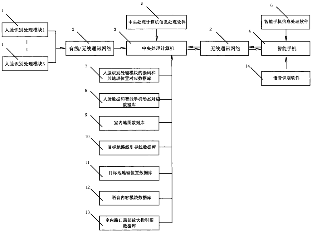
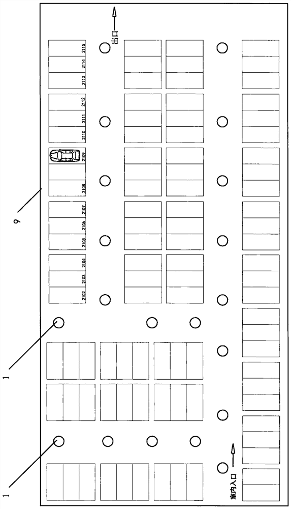
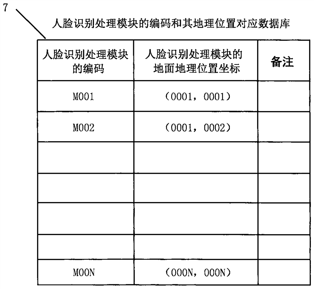
[0098] Refer to attached figure 1 , 2 , 3, 4, 5, 6, 7, 8, 9, the present invention mainly consists of several face recognition processing modules [1], wired / wireless communication network [2], central processing computer [3], smart phone [4] , central processing computer information processing software [5], smart phone information processing software [6], face recognition processing module coding and its geographical location corresponding database [7], face data and smart phone dynamic corresponding database [8], Indoor map database[9], destination route guideline database[10], destination geographic location database[11], voice content module database[12], indoor crossing partial zoom guide map database[13], speech recognition software[14] ]constitute.

[0099] The face recognition processing module [1] is installed above or on the side of the indoor passage (including the inflection point of the passage), the central processing computer [3]...


PUM


Abstract

The invention discloses an indoor positioning and navigation system based on face recognition. The system comprises a plurality of face recognition processing modules, a wired / wireless communication network, a central processing computer, smart phones, central processing computer information processing software, smart phone information processing software, a database of matched codes and geographic positions of the face recognition processing modules, a database of dynamically matched face data and smart phones, an indoor map database, a target place route guide line database, a target place geographic position database, a voice content module database, an indoor intersection local amplification guide map database and voice recognition software. With the system, the indoor current positionof a user can be determined in real time, the user can quickly and directly reach a target place according to an indoor map on an APP, guide lines for the target place, real-time voice prompts and real-time local amplification guide maps for in-field intersections; and the system is high implementation operability and accurate in positioning, user experience is good, and the real effect of outdoor GPS navigation can be achieved.

Description

technical field [0001] The invention relates to an indoor positioning and navigation system based on face recognition. The system can realize the real-time determination of the user's indoor current position. Real-time partial enlarged guide map at intersections, quickly and directly to the destination. [0002] The invention belongs to the field of face recognition positioning technology and indoor map mapping technology, and is particularly suitable for indoor target navigation, shopping mall store navigation, underground garage reverse car search navigation, and the like. Background technique [0003] Because the indoor GPS signal is weak or there is no GPS signal, it is impossible to use the mobile phone indoor GPS positioning and navigation normally, causing the user to blindly search for the target place indoors, which is time-consuming and laborious. [0004] Currently public indoor positioning and navigation technologies include WIFI, Bluetooth, pseudo-GPS, etc. The...

Claims


Application Information

Patent Timeline
IPC IPC(8): G01C21/20G06K9/00
CPCG01C21/206G06V40/16
Inventor 方文淋
Owner 方文淋
Learn More