Automatic city function partitioning method based on remote sensing images and taxi track fusion

A technology of urban functions and remote sensing images, applied in the field of geographic information, can solve problems such as inability to generalize, outdated methods of use, and wide implementation range

Pending Publication Date: 2020-10-23
NANTONG UNIVERSITY
View PDF0 Cites 9 Cited by
  • Summary
  • Abstract
  • Description
  • Claims
  • Application Information

AI Technical Summary

Problems solved by technology

At present, the identification and classification of urban functional areas are mainly carried out on-site survey and digitization by professional and experienced personnel. The implementation range is wide and difficult, and it cannot be automatically updated in a short period of time, resulting in a huge human and material resource expenditure.
At present, some scholars try to use remote sensing or human perception data to mine the functional areas of the city, but the data source is relatively single, and the method of use is relatively old. The identification results are mostly qualitative analysis and summary, and cannot be generalized to other areas.

Method used


Image

  • Automatic city function partitioning method based on remote sensing images and taxi track fusion
  • Automatic city function partitioning method based on remote sensing images and taxi track fusion
  • Automatic city function partitioning method based on remote sensing images and taxi track fusion

Examples


Embodiment Construction

[0046] In order to enable those skilled in the art to better understand the solutions of the present invention, the following will clearly and completely describe the technical solutions in the embodiments of the present invention in conjunction with the drawings in the embodiments of the present invention. Obviously, the described embodiments are only It is a part of embodiments of the present invention, but not all embodiments.

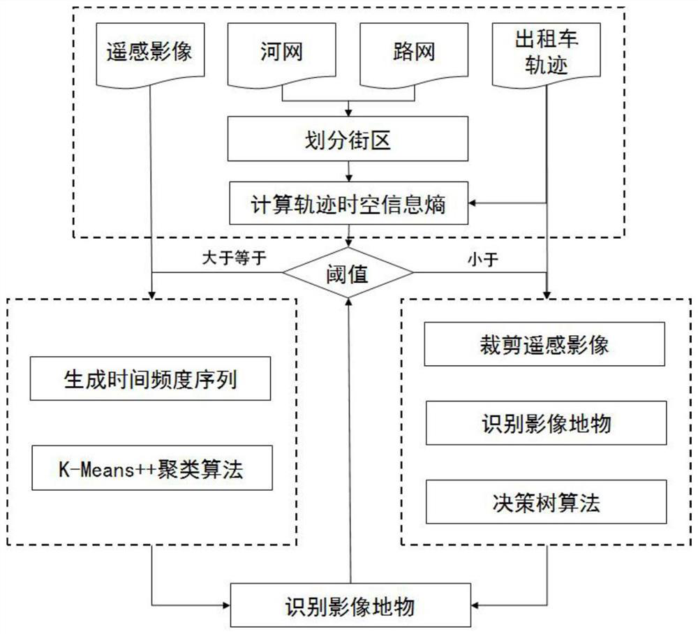
[0047] Such as figure 1 As shown, the embodiment of the present invention provides an automatic urban function zoning method for fusion of remote sensing images and taxi trajectories, comprising the following steps:

[0048] S100. Using roads and rivers to divide the target city into several blocks;

[0049] First, use the open road network acquisition interface provided by Baidu Maps, and use web crawler technology to crawl the road network data and river network data in the target city based on geographical orientation.

[0050] Then, for the ob...


PUM


Abstract

The invention provides an automatic city function partitioning method based on remote sensing images and taxi track fusion. The automatic city function partitioning method includes the steps: firstly,dividing a target city into block units, calculating the track space-time information entropy of each block, setting a preset threshold value, and dividing the blocks into two types of regions, wherein the track information amount of the first region is sufficient, the frequency information of taxi boarding and alighting points in each time period is used as an interpretation mark of the social function category, and a partitioning result is obtained by adopting KMeans++ clustering; in a second region, distinguishing ground objects with typical interpretation marks and non-typical interpretation marks in the remote sensing image, and classifying confidence results of the identified ground objects by using a decision tree to obtain a partitioning result; and adjusting a preset threshold value and repeating the above steps in combination with cross validation until the precision meets specified conditions, and finally obtaining a social function partitioning result of the target city. The automatic city function partitioning method gives full play to the advantages of high spatial precision and continuous time of trajectory data, and combines the advantages of wide coverage of remote sensing images and high ground object recognition capability.

Description

technical field [0001] The invention belongs to the technical field of geographic information, and in particular relates to an automatic urban function partition method for fusion of remote sensing images and taxi tracks. Background technique [0002] The automatic zoning of urban functional areas provides a powerful way for urban planning, design and management, and helps government departments better understand urban planning and layout, so as to provide residents with a happier living environment. At present, the identification and classification of urban functional areas are mainly carried out on-site survey and digitization by professional and experienced personnel, which is difficult to implement in a wide range, and cannot be automatically updated in a short period of time, resulting in a huge expenditure of manpower and material resources. At present, some scholars try to use remote sensing or human perception data to mine the functional areas of the city, but the da...

Claims


Application Information

Patent Timeline
Patent Type & Authority Applications(China)
IPC IPC(8): G06K9/00G06K9/62G06F16/29G06Q50/26
CPCG06F16/29G06Q50/26G06V20/182G06V20/176G06F18/23213
Inventor 周侗钱振闫金伟陶菲王辰怡
Owner NANTONG UNIVERSITY
Why Eureka
Try Eureka