Large-scale scene engineering geology remote sensing interpretation method based on framed digital image

A technology of engineering geology and large scenes, applied in the field of engineering survey, can solve the problems of complex data processing, landform deformation, cumbersome transfer and drawing, etc., and achieve the effect of simple data structure, realistic expression effect and simple transfer and drawing

Inactive Publication Date: 2020-11-10
CHINA RAILWAY FIRST SURVEY & DESIGN INST GRP
View PDF6 Cites 2 Cited by
  • Summary
  • Abstract
  • Description
  • Claims
  • Application Information

AI Technical Summary

Problems solved by technology

For different types of data, geological interpretation is currently mainly based on two-dimensional plane orthophotos, but the digital elevation accuracy in the process of orthophoto production is not high enough to easily cause image distortion and landform deformation. The combined 2.5-dimensional viewing scene cannot truly present the characteristics of the surface landscape. Some technicians will also build a single-image pair stereo environment based on aerial photogrammetry. Space for scaling up

Method used


Image

  • Large-scale scene engineering geology remote sensing interpretation method based on framed digital image
  • Large-scale scene engineering geology remote sensing interpretation method based on framed digital image

Examples


Embodiment Construction

[0036] In order to make the object, technical solution and advantages of the present invention clearer, the present invention will be further described in detail below in conjunction with the accompanying embodiments. Obviously, the described embodiments are only some embodiments of the present invention, rather than all embodiments. Based on the embodiments of the present invention, all other embodiments obtained by persons of ordinary skill in the art without making creative efforts belong to the protection scope of the present invention.

[0037] The present invention will be described in detail below in conjunction with the accompanying drawings and specific embodiments.

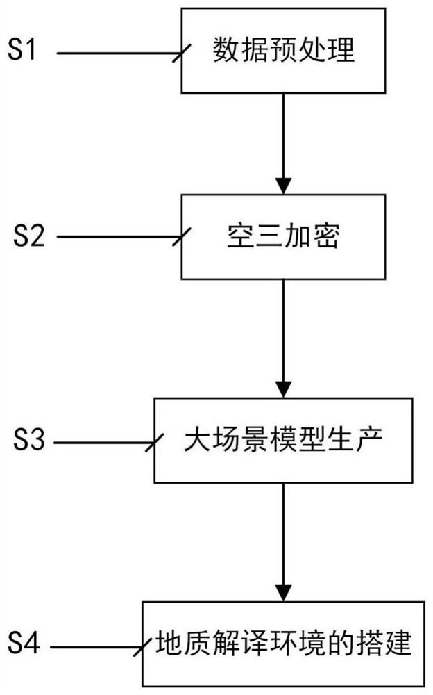
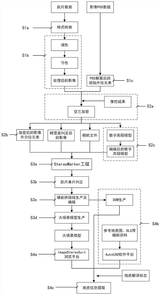
[0038] Based on the image data obtained by the frame-type digital aerial camera, the present invention uses the large scene data production and browsing system to study a set of engineering geological remote sensing interpretation technology for large scenes. , forming a continuous and seamless true thre...


PUM


Abstract

The invention discloses a large-scale scene engineering geology remote sensing interpretation method based on a frame-type digital image, and the method comprises the steps: carrying out the aerial triangulation encryption of data through employing frame-type digital aerial photography data obtained at an engineering geology investigation initial measurement stage, and manufacturing a digital elevation model product through employing an encryption result; and generating large-scale scene model data based on the encrypted camera parameters and accurate image exterior orientation elements, importing the model data and interconnecting the model data with a drawing system, establishing a geological remote sensing interpretation mark, and performing geological remote sensing interpretation in atwo-dimensional and three-dimensional environment interaction association mode. According to the method, a large-scene three-dimensional model product breaks through the limitation of a single imageof traditional aerial photo data on the three-dimensional range, a continuous seamless true three-dimensional model is formed, the expression effect is more vivid, information is richer, the topography and geologic body detail characteristics can be accurately reflected, meanwhile, high-precision aerial triangulation encryption mathematical precision information is reserved, and multi-scale dynamic continuous information extraction can be carried out.

Description

technical field [0001] The invention belongs to the technical field of engineering survey, in particular to a large-scene engineering geological remote sensing interpretation method based on frame-type digital images. Background technique [0002] Remote sensing geological interpretation is the process of obtaining geological phenomena from aerial and aerospace images. Most of them use image data to establish remote sensing interpretation signs of geological bodies or geological phenomena. This technical method has been widely used in regional geological surveys and various engineering geological surveys. [0003] In geological remote sensing surveys, satellite remote sensing images are mainly used for the investigation of regional geological background, mostly using image spectral information, generally with low resolution; aerial photography data image resolution is generally higher than satellite images, mostly based on image texture, shape and other details Characterist...

Claims


Application Information

Patent Timeline
Patent Type & Authority Applications(China)
IPC IPC(8): G01C11/00G06T17/05
CPCG01C11/00G06T17/05
Inventor 刘亚林王玮张占忠武瑞宏何金学袁永信杜世回苗晓岐周福军张晓宇
Owner CHINA RAILWAY FIRST SURVEY & DESIGN INST GRP
Why Eureka
Try Eureka