Highway stake mark and longitude and latitude mapping method for locking key points

A technology of expressway and mapping method, which is applied in the direction of structured data retrieval, instrumentation, geographic information database, etc., can solve problems such as inconsistency of stake numbers at key positions, inconsistency of distance, and inability to map all road sections, achieving low computational complexity and ensuring Accuracy, clear effect of method principle

Pending Publication Date: 2020-11-13
CHONGQING SHOUXUN TECH CO LTD
View PDF0 Cites 2 Cited by
  • Summary
  • Abstract
  • Description
  • Claims
  • Application Information

AI Technical Summary

Problems solved by technology

However, in the face of the current more popular electronic maps, the expressway system marked by stake numbers also exposed some problems
For example, when an accident occurs on an expressway, the person concerned can easily use the mobile phone to locate the current GPS coordinates, but cannot easily obtain the expressway stake number; However, it cannot be pushed to the electronic navigation through the latitude and longitude
[0003] The key reason for these problems is that it is impossible to correspond the chainage of the expressway with the latitude and longitude coordinates in GIS
Firstly, because the stake number data is relatively sparse, mainly kilometer stakes, and the GIS map has not entered the information of the km stake, so it is impossible to correspond; secondly, because the distance marked by the stake number is inconsistent with the distance calculated in the GIS, it is impossible to Mapping the entire road section through the latitude and longitude of the first and last positions of the expressway and the chainage will lead to inconsistencies in the chainage at key positions

Method used


Image

  • Highway stake mark and longitude and latitude mapping method for locking key points
  • Highway stake mark and longitude and latitude mapping method for locking key points
  • Highway stake mark and longitude and latitude mapping method for locking key points

Examples


Embodiment 1

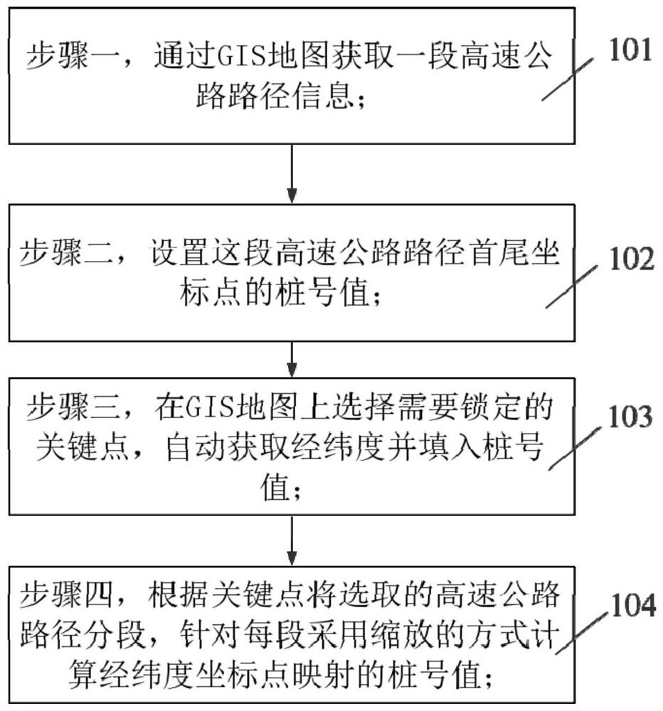
[0041] Such as figure 1 As shown, the embodiment of the present invention provides a method for mapping highway stake numbers and latitude and longitude to lock key points, and the specific implementation steps are:

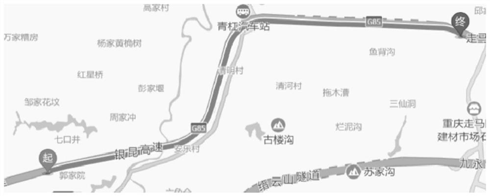
[0042] 101. Obtain the route of a section of expressway through the route planning function of the GIS map, such as figure 2 shown;

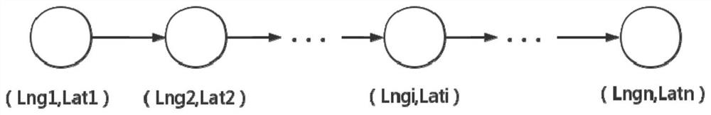
[0043] The obtained path can be expressed as [(Lng1,Lat1),(Lng2,Lat2),(Lngi,Lati)...(Lngn,Latn)] through the latitude and longitude coordinate array, such as image 3 shown;

[0044] 102. Set the chainage value of the first and last coordinate points of this expressway path, automatically obtain the latitude and longitude through the GIS map and fill in the actual chainage value, for example, the starting point is K100+20, and the end point is K110+50, which can be calculated through the first and last points This section of road is 10030 meters in total;

[0045] 103. Select the key points to be locked on the GIS map, such as...


PUM


Abstract

The invention discloses a highway stake mark and longitude and latitude mapping method for locking key points. The method comprises the following steps: step 1, collecting information of a section ofhighway path through a GIS map; 2, setting stake mark values of head and tail coordinate points of the expressway path; 3, selecting key points needing to be locked on the GIS map, automatically collecting longitude and latitude, and filling pile number values; and 4, dividing the selected expressway path into a plurality of sections (L1... Li... Ln) according to the key points, and calculating the stake mark value mapped by the longitude and latitude coordinate points by adopting a zooming mode for each section. According to the method, the stake mark values of the GIS longitude and latitudecoordinates are calculated through a method of locking key point subsection scaling, mutual mapping of stake marks on the expressway and the GIS longitude and latitude coordinates is achieved, and particularly, the accuracy of the key point stake marks is guaranteed by locking key points (toll stations, bridges, tunnels, service areas, entrances and exits and the like).

Description

technical field [0001] The invention relates to the technical field of expressway informatization, in particular to a method for mapping expressway stake numbers and longitudes and latitudes by locking key points. Background technique [0002] In traditional expressway construction and operation management, stake numbers are used to number and locate expressway sections, structures, toll stations, etc. This simple and effective positioning method has played an important role in the past construction and management, and established a national unified expressway chainage network. However, in the face of the current more popular electronic maps, the expressway system marked with stake numbers has also exposed some problems. For example, when an accident occurs on an expressway, the person concerned can easily use the mobile phone to locate the current GPS coordinates, but cannot easily obtain the expressway stake number; However, it cannot be pushed to electronic navigation t...

Claims


Application Information

Patent Timeline
Patent Type & Authority Applications(China)
IPC IPC(8): G06F16/29G06Q50/26
CPCG06Q50/26G06F16/29
Inventor 吴霄王卫平代振唐毅李苓佳向光华陈力云蒋陈虎
Owner CHONGQING SHOUXUN TECH CO LTD
Why Eureka
Try Eureka