Optical remote sensing image forest land classification method based on cascaded deep convolutional neural network

A deep convolution and neural network technology, applied in the field of remote sensing, can solve the problems of less utilization, difficulty in manual labeling, difficult sample data, etc., and achieve the effect of saving labor costs and improving investigation efficiency

Pending Publication Date: 2020-11-17
湖南神帆科技有限公司
View PDF0 Cites 1 Cited by
  • Summary
  • Abstract
  • Description
  • Claims
  • Application Information

AI Technical Summary

Problems solved by technology

[0004] 1) For the semantic segmentation deep network, due to the complexity and variety of forest land types, the boundaries of different forest land types are staggered, which makes manual labeling difficult, so it is difficult to establish better sample data to train the network; The area area and the fine woodland category area are relatively small, so there will also be the problem of unbalanced training samples
[0005] 2) For the image classification deep network, different from the traditional close-range image, because the high-resolution remote sensing image has very rich features and features, it will lead to too many categories, which will affect the acquisition of sample data; in addition, the image classification network The processed small slices (about 80*80) use less contextual information, so it is not conducive to large-format and large-scale remote sensing image classification processing

Method used


Image

  • Optical remote sensing image forest land classification method based on cascaded deep convolutional neural network
  • Optical remote sensing image forest land classification method based on cascaded deep convolutional neural network
  • Optical remote sensing image forest land classification method based on cascaded deep convolutional neural network

Examples


Embodiment Construction

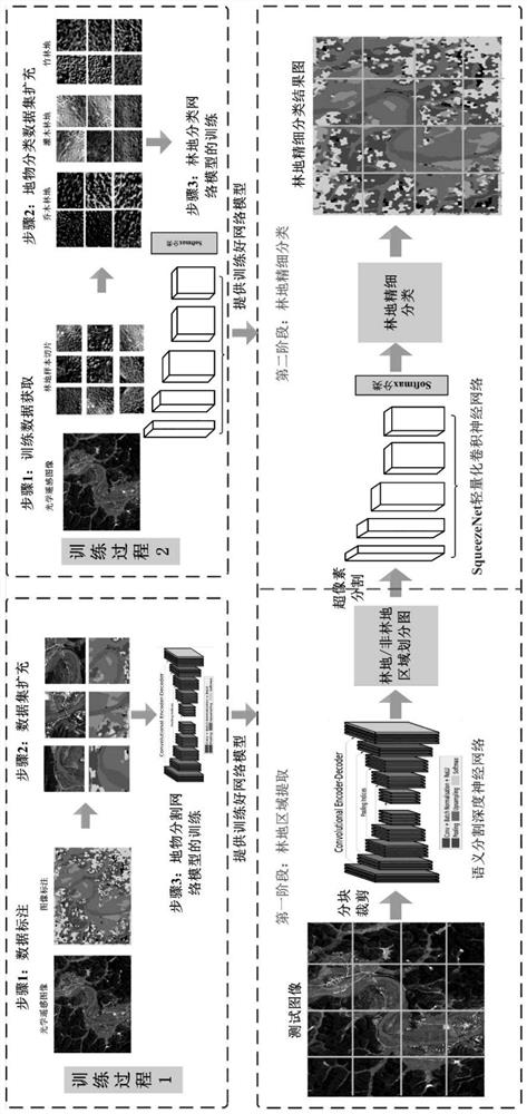
[0028] The present invention comprises the following steps,

[0029] A. Using the image semantic segmentation deep convolutional network to realize the classification of large-grained ground objects in the image, and to realize the division of forest land and non-wood land areas;

[0030] B. Using a deep convolutional neural network for image classification to achieve fine-grained and fine-grained division of woodland areas.

[0031] In step A, the DeepLab-V3 deep network is first trained offline, and then the online image segmentation is based on the DeepLab-V3 deep network.

[0032] The offline training of the DeepLab-V3 deep network includes the following steps,

[0033] Firstly, multiple small-scale remote sensing images are cropped from the large-scale remote sensing images, and then these small-scale remote sensing images are labeled; next, the small-scale remote sensing images and the real value labeled images are expanded; finally, the DeepLab-V3 network is input into...


PUM


Abstract

The invention discloses an optical remote sensing image forest land classification method based on a cascaded deep convolutional neural network, and the method comprises the following steps: A, achieving classification of large-granularity ground features in an image by employing an image semantic segmentation deep convolutional network, and achieving the division of forest land and non-forest land regions; and B, realizing fine granularity division for the forest land regions by utilizing a deep convolutional neural network oriented to image classification. According to the method, the defects in the prior art can be overcome, effective mining of remote sensing image ground feature features by deep learning can be brought into play, efficient learning and extraction of forest land fine features in a high-resolution image are considered, and the problem of forest land fine classification of the high-resolution remote sensing image can be well solved.

Description

technical field [0001] The invention belongs to the technical field of remote sensing, in particular to a forest land classification method for optical remote sensing images based on a cascaded deep convolutional neural network. Background technique [0002] Fine classification of remote sensing image forest land is a very important step in forest resource investigation and has important application value. On the one hand, it is an efficient and economical means of obtaining forest land spatial distribution information and change information. On the other hand, it is also an important auxiliary for forest biomass analysis, especially for the sustainable development and utilization of forest resources. [0003] At present, traditional remote sensing image classification methods are mostly used to achieve fine forest land classification, which is usually based on manually designed image features (such as image spectrum, texture, etc.) combined with shallow classifier learning ...

Claims


Application Information

Patent Timeline
IPC IPC(8): G06T7/11G06N3/08G06N3/04G06K9/62
CPCG06T7/11G06N3/08G06T2207/10032G06T2207/20081G06T2207/20084G06T2207/30204G06T2207/30181G06N3/045G06F18/24G06F18/214
Inventor 李智勇张鹏邓志鹏杨芳
Owner 湖南神帆科技有限公司
Why Eureka
Try Eureka