Method for reconstructing terrains above dry water level of beach based on time sequence remote sensing images and water level monitoring data

A technology of remote sensing images and time series, which is applied in the field of surveying and mapping remote sensing and water conservancy, and can solve the problems of high cost and high risk of collecting continental terrain

Active Publication Date: 2020-11-17
CHANGJIANG RIVER SCI RES INST CHANGJIANG WATER RESOURCES COMMISSION
View PDF4 Cites 11 Cited by
  • Summary
  • Abstract
  • Description
  • Claims
  • Application Information

AI Technical Summary

Problems solved by technology

[0006] The invention provides a method for reconstructing terrain above the dry water level of the river beach based on time series remote sensing images and water level monitoring data, which can solve the problems of high cost and high risk of collecting the landform of the beach in the prior art

Method used


Image

  • Method for reconstructing terrains above dry water level of beach based on time sequence remote sensing images and water level monitoring data
  • Method for reconstructing terrains above dry water level of beach based on time sequence remote sensing images and water level monitoring data
  • Method for reconstructing terrains above dry water level of beach based on time sequence remote sensing images and water level monitoring data

Examples


Embodiment Construction

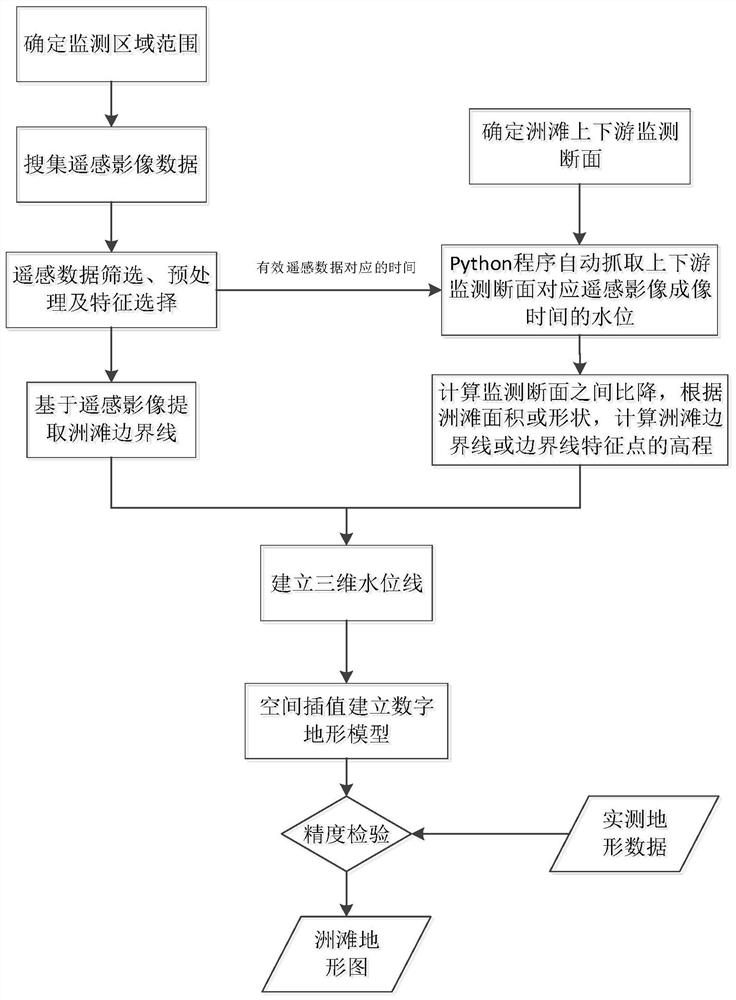
[0032] The technical solutions in the present invention will be clearly and completely described below in conjunction with the accompanying drawings and specific embodiments.

[0033] Such as figure 1 As shown, the embodiment of the present invention provides a method for reconstructing the terrain above the dry water level of the river continent beach based on time series remote sensing images and water level monitoring data, including the following steps:

[0034] Step 1. Determine the river beach whose area changes greatly with the change of river water level within a year as the object of terrain reconstruction;

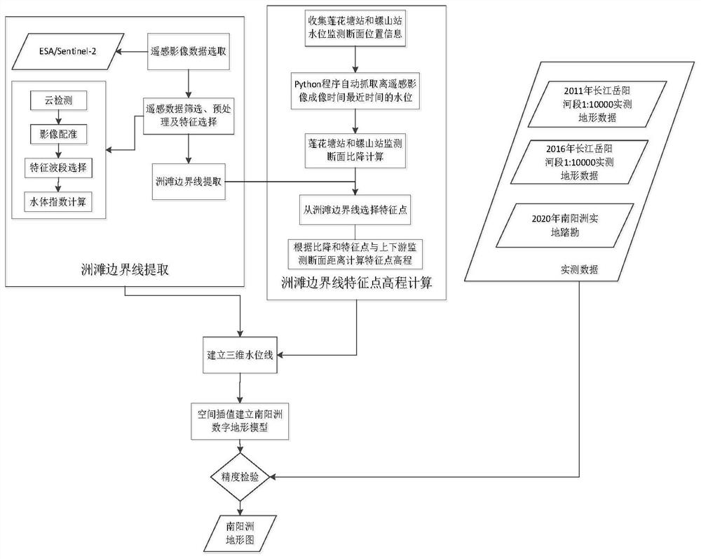
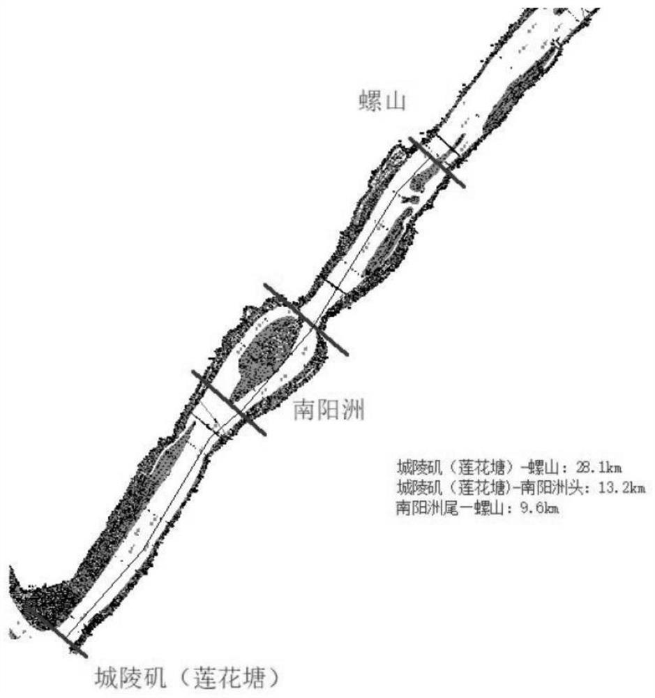
[0035] Step 2, select a typical beach, and determine the nearest hydrological monitoring station on the upstream and downstream of the river according to its location;

[0036] Step 3. Using ESA / Sentinel-2 satellite data as the main data source, collect time-series remote sensing image data of typical continental beaches in any year, and perform image cropping, ...


PUM


Abstract

The invention provides a method for reconstructing terrains above a dry water level of a beach based on time sequence satellite remote sensing data and water level monitoring data, mainly aiming at the river beach of which the area is greatly changed along with the water level in the year. A river beach boundary line of a time sequence is extracted from an ESA/Sentinel2 remote sensing image, waterlevel observation data of nearest hydrological stations at the upstream and the downstream of the beach at corresponding time are automatically captured, the elevation of a beach water line or elevation information of each feature point of the beach water line is obtained, and terrains above the self-dry water line of the beach are established through spatial interpolation. Under the condition that field measurement is not carried out, existing satellite remote sensing data and water level monitoring data are fully utilized, the invention is suitable for the beach with the area obviously changed due to the influence of water level changes, the beach terrains above the dry water line are established, and the invention has great significance in scour silting analysis, protection, development and utilization of the beach.

Description

technical field [0001] The invention relates to the technical fields of surveying, mapping, remote sensing and water conservancy, in particular to a method for reconstructing terrain above the dry water level of a river continent beach based on time series remote sensing images and water level monitoring data. Background technique [0002] Based on the traditional topographic survey method of level and total station, the technical route of regional topographic survey is a topographic survey method from point to line and then to surface. The accuracy of field measurement is high, but the conditions are difficult, the efficiency is low, and the consumption of human and financial resources is large. [0003] Underwater topographic survey is mainly carried out by ship-borne depth sounder. The beach is widely distributed in the river, and the beach is greatly affected by the water level. The area of ​​the beach is large in the dry season, and the area of ​​the beach is small in ...

Claims


Application Information

Patent Timeline
Patent Type & Authority Applications(China)
IPC IPC(8): G06T17/05G06F16/29G01C15/00
CPCG06T17/05G06F16/29G01C15/00Y02A20/402
Inventor 文雄飞元媛张穗向大享王敏郑学东姚仕明刘希胜李喆王岗申邵洪姜莹
Owner CHANGJIANG RIVER SCI RES INST CHANGJIANG WATER RESOURCES COMMISSION
Why Eureka
Try Eureka