An Atmospheric Correction Method for GNSS Reflection Height Measurement

A technology of height measurement and atmosphere, applied in the direction of measuring devices, radio wave measurement systems, instruments, etc., can solve the problems of large limitations and extremely difficult promotion of GNSS reflection measurement, etc., and achieve the effect of strong universality

Active Publication Date: 2021-12-10
CHANGAN UNIV
View PDF0 Cites 0 Cited by
  • Summary
  • Abstract
  • Description
  • Claims
  • Application Information

AI Technical Summary

Problems solved by technology

[0003] However, the existing single-station empirical correction method requires a large amount of measured data to fit the empirical formula, and is only suitable for GNSS reflection height measurement with fixed geographic location and fixed satellite altitude angle, which has great limitations and is extremely difficult to be extended to other user locations. GNSS reflection measurement

Method used


Image

  • An Atmospheric Correction Method for GNSS Reflection Height Measurement
  • An Atmospheric Correction Method for GNSS Reflection Height Measurement
  • An Atmospheric Correction Method for GNSS Reflection Height Measurement

Examples


Embodiment

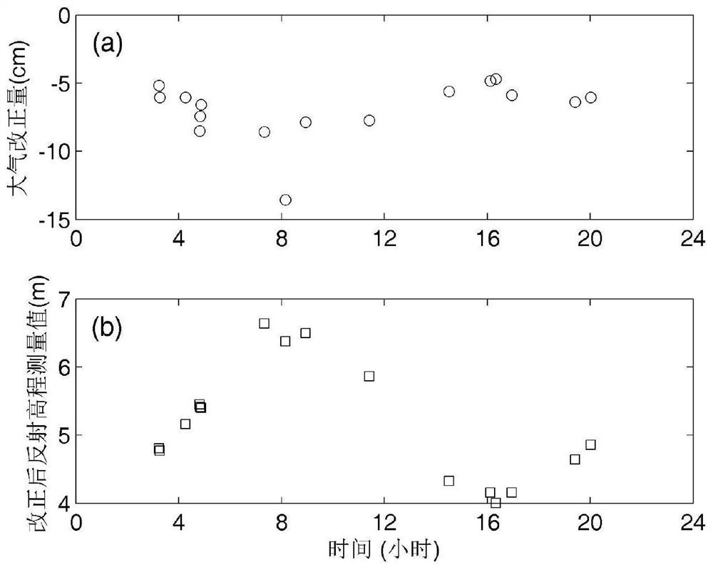
[0067] Using the method of the present invention to GNSS reflection leveling data (sea surface height) 13 January 2016 SC02 stations atmospheric correction, first, using the SNR-data SC02 station GPS L2 frequency is sea measured, calculated January 13, original elevation measurements and the corresponding mean elevation angle satellite table 2 below.

[0068] Table 2 13 January original elevation measurements and the corresponding mean elevation angle satellite stations SC02

[0069] Time (hours) Original elevation measurement (M) Average satellite height angle (degrees) 3.233 4.7549 9.396 3.267 4.7115 8.552 4.272 5.1005 8.966 4.812 5.3662 7.567 4.845 5.3384 8.164 4.878 5.3363 8.759 7.327 6.5502 8.455 8.144 6.2396 6.242 8.927 6.4163 8.799 11.404 5.7891 8.372 14.509 4.2717 8.443 16.118 4.1075 8.975 16.329 3.9572 8.962 16.947 4.0995 8.032 19.420 4.5809 8.168 20.024 4.8017 8.643...


PUM


Abstract

The invention discloses an atmospheric correction method for GNSS reflection height measurement, comprising the following steps: S1: establishing a satellite elevation angle parameter correction number table in GNSS reflection height measurement; S2: calculating the GNSS reflection height measurement satellite to be corrected The average elevation angle e and the original reflection elevation measurement value H; S3: according to the satellite average elevation angle e, in conjunction with the satellite elevation angle parameter correction number table in step S1, calculate the corresponding elevation angle parameter correction number f(e); S4: use Atmospheric correction formula calculates atmospheric correction amount; S5: Calculate the GNSS reflection elevation observation value after atmospheric correction according to the result obtained in step S4. The atmospheric correction method in the present invention aims at the elevation measurement error caused by the atmospheric delay of GNSS reflection measurement, which is convenient and fast to realize Atmospheric correction to improve the accuracy of GNSS reflection height measurement, and has a certain degree of universality.

Description

Technical field [0001] The present invention relates to the field of GNSS reflective elevation measurement, and more particularly to atmospheric correction methods for GNSS reflective elevation measurements. Background technique [0002] The direct signal of the satellite in GNSS technology is used to position, and the reflected signal is generally weakened or inhibited as a multi-path error. Later, people found that the reflected signals carry the physical characteristics information with the reflective surface, started to be used for snow deep, surface settling And high measurement of sea surface. Foundation GNSS-IR (GNSS InterferMetric Reflectometry) has developed into an important high-envelope measurement method, and due to most of the foundation GNSS-IR uses low height angle reflection signals, the atmosphere is delayed (referred to as atmosphere Delayed) The effect of inversion results is remarkable, and must be eliminated in high-precision elevation measurements. When the...

Claims


Application Information

Patent Timeline
Patent Type & Authority Patents(China)
IPC IPC(8): G01S19/14G01S19/21G01S19/27
CPCG01S19/14G01S19/21G01S19/27
Inventor 胡羽丰李振洪
Owner CHANGAN UNIV
Why Eureka
Try Eureka