Forecasting method for village and town-level atmospheric pollution traceability

A township-level technology, applied in the forecasting field of air pollution traceability at the township level, can solve problems such as the inability to trace the source of air pollution in townships and townships, and achieve the effect of realizing pollution contribution and improving accuracy

Pending Publication Date: 2020-12-25
南京创蓝科技有限公司 +1
View PDF1 Cites 8 Cited by
  • Summary
  • Abstract
  • Description
  • Claims
  • Application Information

AI Technical Summary

Problems solved by technology

[0007] The present invention overcomes the deficiency in the prior art that it is impossible to timely and effectively forecast the traceability of air pollution in towns and towns, and provides a forecast method for traceabi

Method used


Image

  • Forecasting method for village and town-level atmospheric pollution traceability
  • Forecasting method for village and town-level atmospheric pollution traceability
  • Forecasting method for village and town-level atmospheric pollution traceability

Examples


Embodiment 1

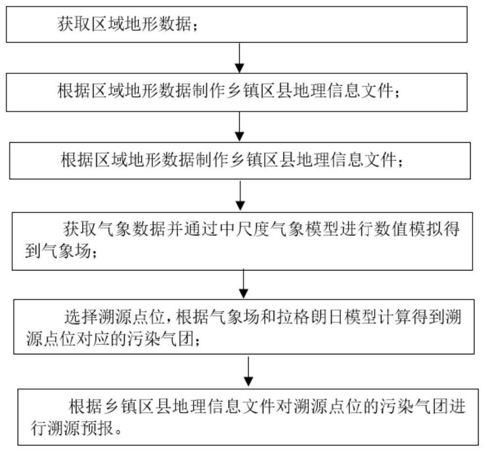
[0030] combine figure 1 As shown, a method for forecasting traceability of air pollution in a township of the present invention specifically includes the following steps:

[0031] 1) Obtain terrain data

[0032] Obtain regional terrain data, specifically, use satellites to acquire radar image data, and obtain SRTM terrain data according to the radar image data. In this embodiment, the interpolation algorithm is used to process the radar image data to obtain SRTM terrain data; it is worth noting that the SRTM terrain data is divided into SRTM1 data and SRTM3 data according to the resolution accuracy, wherein the resolution accuracy of the SRTM1 data is 30 meters, The resolution accuracy of SRTM3 data is 90 meters.

[0033] 2) Make geographic information files

[0034] The geographical information files of townships, districts and counties are prepared according to the regional terrain data; specifically, the geographical information files of townships, districts and counties...

Embodiment 2

[0050] The content of this embodiment is basically the same as that of Embodiment 1. Further, in this embodiment, the method of Embodiment 1 is applied to the traceability and forecasting of air pollution at the urban and county level, including the following steps:

[0051] (1) Obtain topographic data of a certain city to form a localized digital topography of the city.

[0052] (2) According to the administrative division of a certain city, prepare the shp files of 11 municipal districts to provide a basis for the division of the footprint of the polluted air mass.

[0053] (3) Terrain data is gridded and assimilated into a mesoscale meteorological model to improve the weather forecast effect of numerical simulation and truly reflect the influence of the latest underlying surface conditions on the traceability of air pollution.

[0054] (4) Simulate the GFS meteorological data through the mesoscale meteorological model to calculate the three-dimensional meteorological field ...


PUM


Abstract

The invention, which belongs to the technical field of air quality prediction, relates to a forecasting method for village and town-level atmospheric pollution traceability. The method comprises the following steps: obtaining regional topographic data; manufacturing a town district and county geographic information file according to the regional topographic data; gridding the regional topographicdata and assimilating the regional topographic data to a mesoscale meteorological model; obtaining meteorological data and performing numerical simulation through a mesoscale meteorological model to obtain a meteorological field; then selecting a traceability point location, and calculating to obtain a pollution gas mass corresponding to the traceability point location according to the meteorological field and a Lagrange model; and carrying out traceability prediction on the polluted gas mass at the traceability point location according to the town district and county geographic information file. The method overcomes a defect that the village and town atmospheric pollution traceability cannot be effectively forecasted in time in the prior art, the forecasting method of the village and town-level atmospheric pollution traceability is provided, the forecasting of the atmospheric pollution traceability can be timely and effectively realized, and accuracy of the atmospheric pollution traceability forecasting can be improved.

Description

technical field [0001] The invention belongs to the technical field of air quality forecasting, and more specifically relates to a forecasting method for tracing the source of air pollution at the township level. Background technique [0002] In the real environment, due to the limitation of the stage of economic development, unreasonable economic development mode is often accompanied by damage to the environment. The deteriorating air pollution situation has led to many bad consequences. For example, it endangers human health, causes certain damage to the growth of animals and plants, and is also harmful to long-term economic development. With the progress of the times, the state attaches great importance to environmental governance, changes in the mode of economic development, and the advocacy of green economy. At present, the emphasis on the atmospheric environment has risen to the national level. In the process of promoting industrialization and urbanization, more and ...

Claims


Application Information

Patent Timeline
IPC IPC(8): G06F30/20G06F16/29G01N15/06G06F111/10
CPCG06F30/20G06F16/29G01N15/06G06F2111/10
Inventor 周德荣唐鑫刘良冬
Owner 南京创蓝科技有限公司
Why Eureka
Try Eureka