Method for analyzing ecological change trend by utilizing space-time ecological environment remote sensing fractal dimension

An ecological environment and changing trend technology, applied in the field of ecological environment remote sensing monitoring and geographic information science, can solve problems such as uncertainty, non-ecological significance, and impact, and achieve the effect of solving uncertain problems.

Active Publication Date: 2021-01-08
HUAZHONG NORMAL UNIV
View PDF4 Cites 5 Cited by
  • Summary
  • Abstract
  • Description
  • Claims
  • Application Information

AI Technical Summary

Problems solved by technology

[0005] (3) From the perspective of spatial statistical analysis, if the analysis is carried out with the help of administrative regions, its range is artificially fixed and has no ecological significance
If the buffer is used for analysis, the result is affected by the size of the buffer, which is uncertain

Method used


Image

  • Method for analyzing ecological change trend by utilizing space-time ecological environment remote sensing fractal dimension
  • Method for analyzing ecological change trend by utilizing space-time ecological environment remote sensing fractal dimension
  • Method for analyzing ecological change trend by utilizing space-time ecological environment remote sensing fractal dimension

Examples


Embodiment Construction

[0016] In order to facilitate those of ordinary skill in the art to understand and implement the present invention, the present invention will be described in further detail below in conjunction with the accompanying drawings and embodiments. It should be understood that the implementation examples described here are only used to illustrate and explain the present invention, and are not intended to limit this invention.

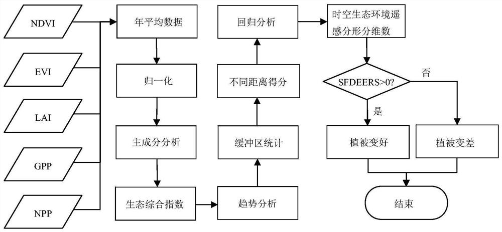
[0017] The embodiment of the present invention is that the ecological impact of the China-Laos railway construction is carried out to measure the fractal and fractal dimension of the space-time ecological environment remote sensing, referring to figure 1 , a kind of utilization time-space ecological environment remote sensing fractal fractal dimension analysis ecological change trend method provided by the invention comprises the following steps:

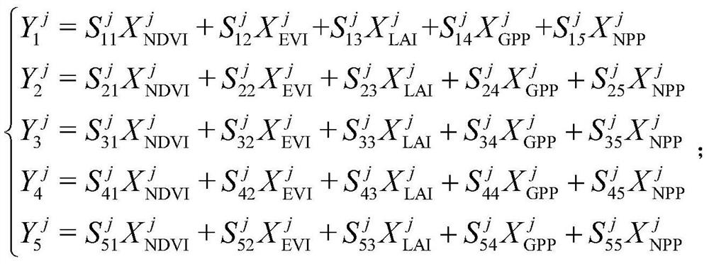
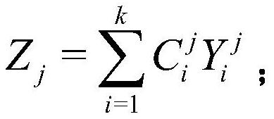
[0018] Step 1: Obtain a number of product data reflecting vegetation conditions, and preprocess the image data; ...


PUM


Abstract

The invention discloses a method for analyzing an ecological change trend by utilizing a space-time ecological environment remote sensing fractal dimension, which comprises the following steps of: firstly, acquiring five remote sensing product data of NDVI, EVI, LAI, GPP and NPP in a certain time period of a certain region, and removing abnormal values; then obtaining monthly scale data, and obtaining annual average data through averaging; then, expanding the buffer area from the location to the outside, and performing normalization and principal component analysis processing on the annual average data in the range of the buffer area to obtain ecological comprehensive index data. then, carrying out trend analysis, classification score statistics and statistics of different buffer area ranges on time series data of the ecological comprehensive index data, taking logarithms of scores and distance variables, and performing linear regression fitting to obtain the slope, wherein the slope is the remote sensing fractal dimension of the space-time ecological environment; and finally, comparing the slope with 0, if the slope is greater than 0, indicating that the vegetation becomes better,and if the slope is smaller than 0, indicating that the vegetation becomes worse. The method can judge the deterioration trend and degree of the ecological vegetation from time and space.

Description

technical field [0001] The invention belongs to the fields of ecological environment remote sensing monitoring and geographic information science, and relates to a method for evaluating temporal and spatial uncertainty of regional ecological environment changes by means of remote sensing, and specifically relates to a method for analyzing ecological change trends by using fractal and fractal dimensions of temporal and spatial remote sensing ecological environment. Background technique [0002] Remote sensing monitoring technology has been widely used in natural resource management, natural disaster monitoring, ecological environment monitoring, etc., and has important application value in agriculture, forestry, geology, environmental protection and other fields. Remote sensing monitoring technology can be roughly divided into two categories: remote sensing index-based and remote sensing interpretation-based remote sensing monitoring technology. The monitoring technology base...

Claims


Application Information

Patent Timeline
Patent Type & Authority Applications(China)
IPC IPC(8): G06K9/00G06Q10/06G06F17/18
CPCG06F17/18G06Q10/06393G06V20/188Y02A90/10
Inventor 李畅詹杰
Owner HUAZHONG NORMAL UNIV
Why Eureka
Try Eureka