Inland lake and reservoir cyanobacterial bloom intensity evaluation method and device based on remote sensing
A technology for cyanobacteria bloom and intensity evaluation, applied in character and pattern recognition, image data processing, instruments, etc., can solve the problems of unevaluated areas of cyanobacteria blooms, human activities, and threats to water intakes of cyanobacteria blooms
- Summary
- Abstract
- Description
- Claims
- Application Information
AI Technical Summary
Problems solved by technology
Method used
Image
Examples
Embodiment 1
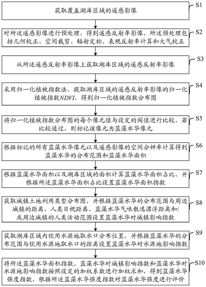
[0063] Embodiments of the present invention provide a method for evaluating the intensity of cyanobacterial blooms in inland lakes based on remote sensing, such as figure 1 As shown, the method includes:
[0064] S1: Obtain remote sensing images covering the lake and reservoir area.
[0065] In this step, satellite remote sensing image data with red light (630nm-690nm) and near-infrared (760nm-900nm) bands are selected. The spatial resolution of remote sensing images should depend on the size of the lake reservoir area, the smaller the lake reservoir area, the higher the spatial resolution requirement. The remote sensing image data covers at least 90% of the lake area; within the lake area, the cloud coverage is less than 50%.
[0066] S2: Preprocess the remote sensing image to obtain the remote sensing albedo image. The preprocessing includes geometric correction, space cropping, radiometric calibration, apparent albedo calculation and atmospheric correction.
[0067] Geom...
Embodiment 2
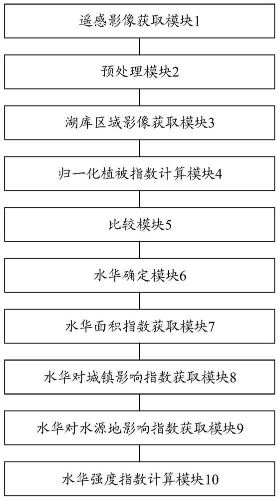
[0130] Embodiments of the present invention provide a remote sensing-based evaluation device for the intensity of cyanobacterial blooms in inland lakes, such as figure 2 shown, which includes:
[0131] The remote sensing image acquisition module 1 is used to acquire remote sensing images covering the lake area.
[0132] The preprocessing module 2 is configured to preprocess the remote sensing image to obtain a remote sensing albedo image. The preprocessing includes geometric correction, space cropping, radiometric calibration, apparent reflectance calculation and atmospheric correction.
[0133] The lake area image acquisition module 3 is used to acquire the remote sensing albedo image of the lake area from the remote sensing albedo image.
[0134] The normalized difference vegetation index calculation module 4 is used to adopt the normalized difference vegetation index method to extract the normalized difference vegetation index NDVI of the remote sensing albedo image of th...
PUM
 Abstract
Description
Claims
Application Information
 - R&D
- Intellectual Property
- Life Sciences
- Materials
- Tech Scout
- Unparalleled Data Quality
- Higher Quality Content
- 60% Fewer Hallucinations
Browse by: Latest US Patents, China's latest patents, Technical Efficacy Thesaurus, Application Domain, Technology Topic, Popular Technical Reports.
© 2025 PatSnap. All rights reserved.Legal|Privacy policy|Modern Slavery Act Transparency Statement|Sitemap|About US| Contact US: help@patsnap.com


