Municipal engineering measurement positioning method and system

A technology for engineering surveying and positioning methods, applied in structured data retrieval, instruments, geographic information databases, etc., can solve problems such as multiple rework, impact on construction period, and inability to coordinate, so as to improve accuracy, facilitate modification and correction, and improve measurement The effect of precision

Pending Publication Date:
View PDF4 Cites 1 Cited by
  • Summary
  • Abstract
  • Description
  • Claims
  • Application Information

AI Technical Summary

Problems solved by technology

[0004] In view of this, the embodiment of the present invention expects to provide a municipal engineering survey and positioning method and system to solve the problem that in the traditional engineering survey and positioning method, due to the inability to cooperate with various professional design schemes, hidden problems cause multiple reworks and affect the construction period.

Method used


Image

  • Municipal engineering measurement positioning method and system
  • Municipal engineering measurement positioning method and system
  • Municipal engineering measurement positioning method and system

Examples


Embodiment 1

[0040] Additional aspects and advantages of embodiments of the invention will be set forth in the description which follows, and in part will be obvious from the description, or may be learned by practice of embodiments of the invention.

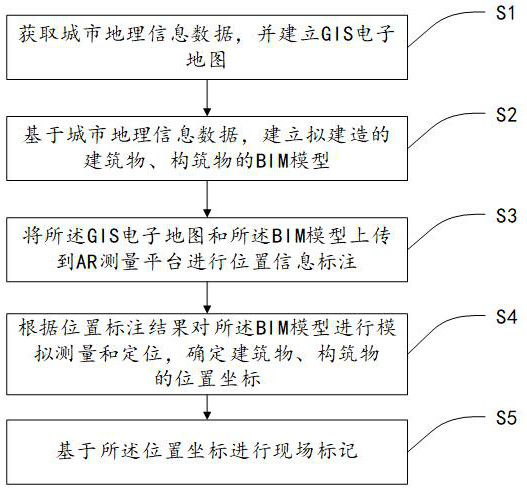
[0041] figure 1 It is a flow chart of a municipal engineering survey and positioning method provided according to an embodiment of the present invention, as shown in figure 1 As shown, the method includes:

[0042] S1: Acquire urban geographic information data and create a GIS electronic map.

[0043] S2: Establish the BIM model of the proposed buildings and structures based on the urban geographic information data.

[0044] S3: uploading the GIS electronic map and the BIM model to the AR measurement platform for labeling position information.

[0045] S4: Carry out simulated measurement and positioning of the BIM model according to the position labeling results, and determine the position coordinates of buildings and structures.
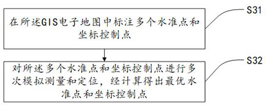
[0046...

Embodiment 2

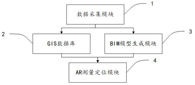
[0059] image 3 It is a schematic structural diagram of a municipal engineering survey and positioning system provided according to an embodiment of the present invention, as shown in image 3 shown, including:

[0060] Data acquisition module 1, used for urban geographic information data;

[0061] GIS database 2, for setting up GIS electronic map according to described city geographic information data;

[0062] BIM model generation module 3, is used for generating the BIM model of building, structure to be built according to described urban geographic information data;

[0063] The AR measurement and positioning module 4 is used to upload the GIS electronic map and the BIM model to the AR measurement platform for position information labeling, and perform simulated measurement and positioning of the BIM model according to the position labeling results to determine buildings and structures location coordinates.

[0064] Specifically, in the data collection module 1, the co...


PUM


Abstract

The invention discloses a municipal engineering measurement positioning method and system, and the method comprises the steps: obtaining urban geographic information data, building a GIS electronic map, building a BIM model of a building and a structure to be built based on the urban geographic information data, uploading the GIS electronic map and the BIM model to an AR measurement platform for position information marking, and performing simulation measurement and positioning on the BIM model according to a position marking result, determining position coordinates of buildings and structures, and performing field marking based on the position coordinates. The system comprises a data acquisition module, a GIS database, a BIM model generation module and an AR measurement positioning module. According to the municipal engineering measurement positioning method and system, the BIM technology and the AR technology are combined through the AR measurement platform, the standard points and the coordinate control points are marked on the electronic map of the AR measurement platform, the building is positioned in combination with the BIM information model, and finally the result is put into the scene, so that the process is more efficient and refined.

Description

technical field [0001] The invention belongs to the technical field of engineering survey, and in particular relates to a municipal engineering survey and positioning method and system. Background technique [0002] With the development of my country's economy, the process of urbanization is accelerating, and the construction of municipal infrastructure is becoming more and more intense. We refer to the measurement work required in the design, construction, completion and operation management stages of various public facilities in the city as municipal engineering measurement. At present, the measurement of individual municipal projects is mostly carried out on the basis of urban survey control network and large-scale topographic maps of the city. The main axis points of various municipal projects adopt the unified coordinate and elevation system of the city. The urban road network is the skeleton of the city's plane layout, and the land use scope of urban projects is often...

Claims


Application Information

Patent Timeline
Patent Type & Authority Applications(China)
IPC IPC(8): G06F30/13G06F16/29G06Q50/08
CPCG06F30/13G06F16/29G06Q50/08
Inventor 黄超许锦林袁凤瑞徐林筝郑志杰王立强尤旺龙魏宗贞陈蕃鸿王依列
Why Eureka
Try Eureka