Geomagnetic map and construction method and device thereof
A map construction and geomagnetic technology, applied in the direction of surveying devices, ground navigation, satellite radio beacon positioning systems, etc., can solve the problems of applicable scenarios, hardware and software requirements, etc., to reduce the workload of data collection, low cost, fast effect
- Summary
- Abstract
- Description
- Claims
- Application Information
AI Technical Summary
Problems solved by technology
Method used
Image

Examples
Embodiment Construction
[0022] Hereinafter, exemplary embodiments according to the present application will be described in detail with reference to the accompanying drawings. Apparently, the described embodiments are only some of the embodiments of the present application, rather than all the embodiments of the present application. It should be understood that the present application is not limited by the exemplary embodiments described here.
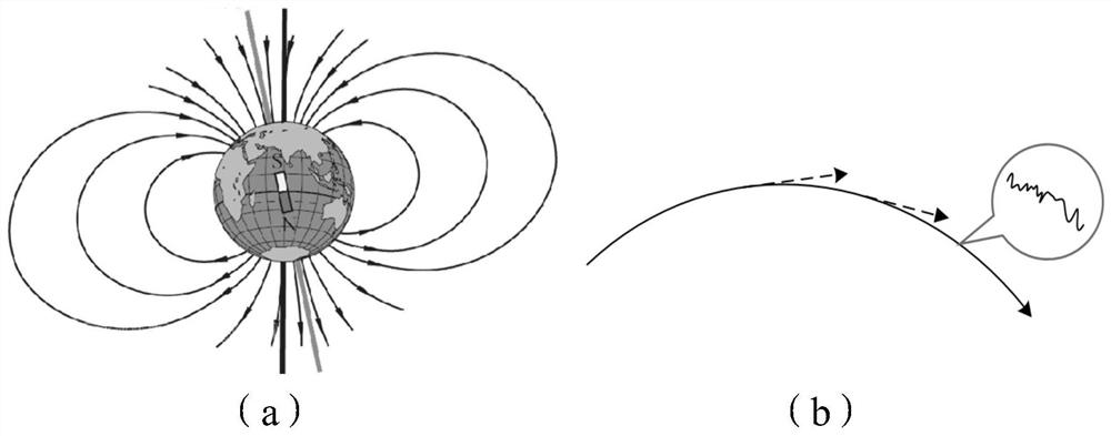
[0023] figure 1 A schematic diagram of the Earth's magnetic field is shown. Such as figure 1 As shown in (a), the geographic north pole roughly corresponds to the geomagnetic south pole, the geographic south pole roughly corresponds to the geomagnetic north pole, and the geomagnetic field is similar to the magnetic field distribution of a bar magnet. Although studies have shown that the north and south poles of the geomagnetic field will move, this movement is very slow and very small compared to the scale of the entire earth. Therefore, the geomagnetic fie...
PUM
 Abstract
Description
Claims
Application Information
 - Generate Ideas
- Intellectual Property
- Life Sciences
- Materials
- Tech Scout
- Unparalleled Data Quality
- Higher Quality Content
- 60% Fewer Hallucinations
Browse by: Latest US Patents, China's latest patents, Technical Efficacy Thesaurus, Application Domain, Technology Topic, Popular Technical Reports.
© 2025 PatSnap. All rights reserved.Legal|Privacy policy|Modern Slavery Act Transparency Statement|Sitemap|About US| Contact US: help@patsnap.com