Three-dimensional traffic vehicle positioning method based on unmanned aerial vehicle

A three-dimensional, vehicle positioning technology, applied in satellite radio beacon positioning systems, positioning, radio wave measurement systems, etc., can solve problems such as signal occlusion, deviation, and positioning work cannot be performed

Pending Publication Date: 2021-03-16
BEIHANG UNIV
View PDF0 Cites 3 Cited by
  • Summary
  • Abstract
  • Description
  • Claims
  • Application Information

AI Technical Summary

Problems solved by technology

In some special areas, such as "urban canyons" with dense high-rise buildings, due to the signal being blocked and the serious multipath effect, there will be a large deviation between the positioning result and the actual position, and even cause the positioning work to fail

Method used


Image

  • Three-dimensional traffic vehicle positioning method based on unmanned aerial vehicle
  • Three-dimensional traffic vehicle positioning method based on unmanned aerial vehicle
  • Three-dimensional traffic vehicle positioning method based on unmanned aerial vehicle

Examples


Embodiment Construction

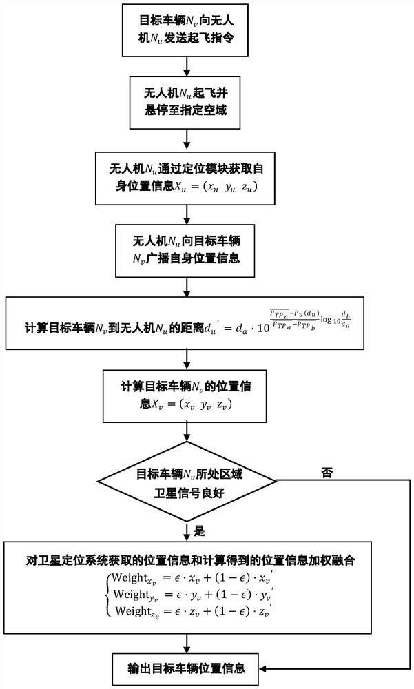
[0036] The present invention will be further described below in conjunction with the accompanying drawings.

[0037] The present invention is a three-dimensional traffic vehicle positioning method based on unmanned aerial vehicles, such as figure 1 As shown, it is realized through the following steps:

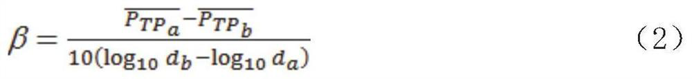
[0038] Step 1. Select an area with weak satellite signals, and the target vehicle in this area includes: a V2X communication module, which is used to complete the communication between the vehicle and the UAV. The target vehicle is identified as N v , the position of the target vehicle is recorded as X v . The drone is equipped on the target vehicle and the number of drones is not less than three. The vehicle sends a take-off command to the drone. After receiving the take-off command, the drone takes off and flies to the airspace, keeping the drone hovering It is located within the communication network coverage of the target vehicle with the communication distance L=300m a...


PUM


Abstract

The invention discloses a three-dimensional traffic vehicle positioning method based on an unmanned aerial vehicle. The method comprises the steps that firstly, an area with weak satellite signals orwithout satellite signals is selected, and a target vehicle is located in the area; the vehicle sends a take-off instruction to the unmanned aerial vehicle, the unmanned aerial vehicle takes off and flies to the airspace after receiving the take-off instruction, the unmanned aerial vehicle is kept to hover in a communication network coverage range with the communication distance as the radius of the target vehicle, and it is guaranteed that the position relation of the unmanned aerial vehicle is nonlinear; secondly, the unmanned aerial vehicle obtains position information under an earth coordinate system through a positioning module of the unmanned aerial vehicle, and broadcasts the position information of the unmanned aerial vehicle to a target vehicle through V2X communication; and finally, the target vehicle receives the position information of the unmanned aerial vehicle and calculates the distance to the unmanned aerial vehicle, so that the position of the target vehicle is calculated, and the positioning requirement of the target vehicle is met under the condition that the satellite positioning system cannot obtain a good positioning effect.

Description

Technical field: [0001] The patent of the present invention relates to the field of positioning of the Internet of Vehicles, in particular to a three-dimensional traffic vehicle positioning method based on an unmanned aerial vehicle. Background technique: [0002] With the rapid development of Internet information technology, the trend of intelligence and networking is becoming more and more prominent. Affected by this, the Internet of Vehicles technology is rising day by day, and its development speed is accelerating. my country has raised the development of Internet of Vehicles and Intelligent Networked Vehicles to the national strategic level. Intelligent networked vehicles use some advanced on-board sensors, controllers, actuators and other devices, and integrate modern communication and network technologies to realize the exchange and sharing of intelligent information between vehicles and people, vehicles, roads, backgrounds, etc., to achieve safety, comfort, and energ...

Claims


Application Information

Patent Timeline
Patent Type & Authority Applications(China)
IPC IPC(8): G01S5/10G01S19/46
CPCG01S5/10G01S19/46
Inventor 段续庭赵文笙田大新周建山韩旭郎平林椿眄赵元昊郑坤贤闫慧文黄米琪王奇徐世魁郝威龙科军刘赫拱印生
Owner BEIHANG UNIV
Why Eureka
Try Eureka