Mass data aggregation method suitable for multistage gridding management system

A technology of massive data and management system, applied in structured data retrieval, geographic information database, still image data clustering/classification, etc., can solve problems such as unstable and linear display aggregation points, and achieve the effect of solving performance problems

Pending Publication Date: 2021-03-23
HEBEI ZHISHENG INFORMATION TECH CO LTD
View PDF4 Cites 1 Cited by
  • Summary
  • Abstract
  • Description
  • Claims
  • Application Information

AI Technical Summary

Problems solved by technology

[0011] The purpose of this application is to provide a mass data aggregation method suitable for multi-level grid management sys...

Method used


Image

  • Mass data aggregation method suitable for multistage gridding management system
  • Mass data aggregation method suitable for multistage gridding management system

Examples


Embodiment Construction

[0024] The technical solutions in the embodiments of the present invention are clearly and completely described below in conjunction with the accompanying drawings in the embodiments of the present invention. Obviously, the described embodiments are part of the embodiments of the present invention, but not all of them. Based on the embodiments of the present invention, all other embodiments obtained by those skilled in the art without making creative efforts belong to the protection scope of the present invention.

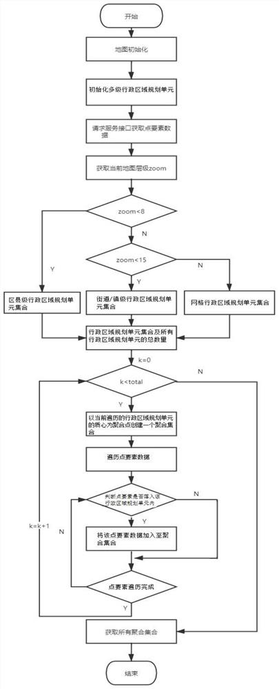
[0025] like figure 1 As shown, the present application provides a massive data aggregation method suitable for a multi-level grid management system, including the following steps:

[0026] S210: Initialize the map.

[0027] Specifically, a map is displayed.

[0028] S220: Initialize the multi-level administrative area planning unit.

[0029] Specifically, a multi-level administrative area planning unit is obtained, so that multiple administrative area planning u...


PUM


Abstract

The invention discloses a mass data aggregation method suitable for a multistage gridding management system. The method comprises the steps of initializing a map; initializing a multistage administrative region planning unit; acquiring point element data; obtaining all administrative region planning unit sets displayed under the current map hierarchy and the total number of all administrative region planning units; traversing the administrative region planning unit set and the point element data, and processing the administrative region planning unit set and the point element data by using thetotal number of administrative region planning units to obtain all aggregation sets; and positioning all the aggregation sets to corresponding grid longitudes and latitudes, and rendering the aggregation sets to a map for display. According to the method and the device, the problems of linear display and unfixed aggregation points during aggregation of massive data points can be solved.

Description

technical field [0001] The present application relates to the technical field of electronic maps, in particular to a massive data aggregation method applicable to a multi-level grid management system. Background technique [0002] With the GIS (Geographic Information System, Geographic Information System) in various grid management (grid management, it is based on the principles of territorial management, geographical layout, status management, etc., divide the jurisdiction area into several grids according to certain standards Shaped units, and implement dynamic and comprehensive management for each grid) system, the point elements expressing spatial information (such as coordinate positions) in the map have become an important part of GIS, such as environmental monitoring point resources, Space point elements such as the real-time location of law enforcement officers. However, displaying a large number of point elements on the browser side will cause the following problem...

Claims


Application Information

Patent Timeline
IPC IPC(8): G06F16/29G06F16/54G06F16/55
CPCG06F16/29G06F16/54G06F16/55
Inventor 薛守宁张号林琦
Owner HEBEI ZHISHENG INFORMATION TECH CO LTD
Why Eureka
Try Eureka