Supercharge Your Innovation With Domain-Expert AI Agents!

High-precision autonomous inspection image recognition method for unmanned aerial vehicle on power transmission line

A power transmission line and image recognition technology, applied in scene recognition, character and pattern recognition, computer components, etc., can solve problems such as complex recognition algorithms, large background interference, and low image clarity, and achieve optimal flight speed and height, Effects of improving clarity and reducing image buffering time

Inactive Publication Date: 2021-04-06
LIAONING TECHNICAL UNIVERSITY
View PDF0 Cites 3 Cited by
  • Summary
  • Abstract
  • Description
  • Claims
  • Application Information

AI Technical Summary

Problems solved by technology

[0006] The purpose of the present invention is to solve the problems of complex recognition algorithm, low image definition and large background interference, and propose a high-precision autonomous inspection image recognition method for UAVs on transmission lines

Method used


Image

  • High-precision autonomous inspection image recognition method for unmanned aerial vehicle on power transmission line
  • High-precision autonomous inspection image recognition method for unmanned aerial vehicle on power transmission line
  • High-precision autonomous inspection image recognition method for unmanned aerial vehicle on power transmission line

Examples


Embodiment 1

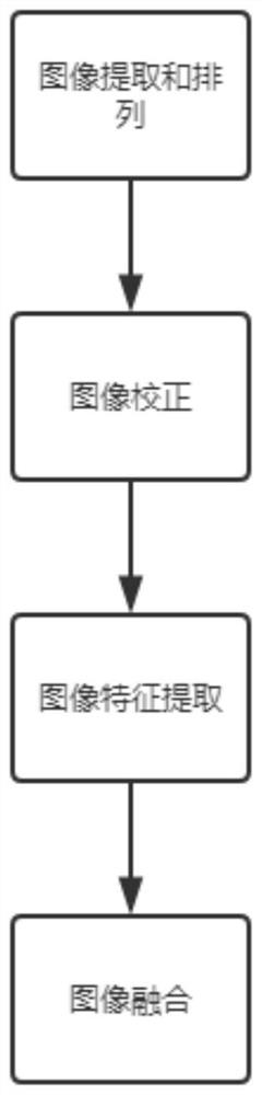
[0030] A high-precision autonomous inspection image recognition method for UAVs on transmission lines, including the following steps:

[0031] S1. Export the photos taken by the UAV, and expand the video files for full-coverage route planning, set 20-30 frames of video images on the flight belt of the UAV as one image unit, and extract one frame of image ;

[0032] S2. Calculate the correlation degree and translation amount of each frame image for the image extracted in S1, and arrange the extracted images according to the correlation degree and translation amount;

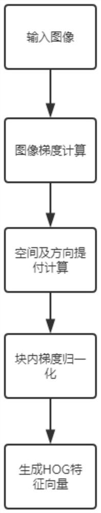
[0033] S3. Perform image geometric correction on the image arranged in S2, perform coordinate conversion on the image, and then directly perform grayscale resampling. The minimum pixel points of the image grid in the X and Y directions are 50, and the pixel point data is passed The management node sends it to each other pixel point. After the operation is completed, the operation result of each pixel point is sen...

Embodiment 2

[0046] For the expansion of the video files shot for full-coverage route planning, set 25 frames of video images on the flight belt of the drone as an image unit, extract one frame of image, and the image size is 340*380, so that the appearance of a single frame image is more obvious Image elimination of virtual blur, offset and scale change, and calculate the correlation and translation of each frame of images through the ground monitoring system to restore the real image order;

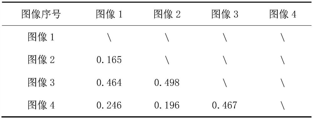
[0047] Table 1 Statistical Table of Image Correlation

[0048]

[0049] In Table 1 above, the maximum value of correlation is 0.498 in image 3 and image 2, and the minimum value is in image 2 and image 1. It can be determined that the head image of the sequence is 2 and the tail image is 3.

[0050] Table 2 Horizontal Offset Statistical Table

[0051]

[0052]

[0053] From Table 2 above, it can be concluded that the real shooting sequence is image 2, image 1, image 4 and image 3.

[0054] ...


PUM


Abstract

The invention discloses a high-precision autonomous inspection image recognition method for an unmanned aerial vehicle on a power transmission line, and belongs to the field of electric power overhaul image recognition. The high-precision autonomous inspection image recognition method for the unmanned aerial vehicle on the power transmission line aims at image recognition and processing of electric power facilities, and comprises the following specific steps: image sorting, image geometric correction, image feature extraction and image fusion, an HOG feature extraction method is used for conducting feature extraction on images, image fusion is conducted in a weighted average mode, and the result shows that under the condition that background interference of a power transmission line is large, the image processing flow can well complete an image recognition task, the image buffer time is reduced because an image processing algorithm capable of selecting a processing time period and an operation speed is selected, the other part of reasons are related to reduction of a long-distance transmission rate, the definition of the acquired image is improved, the method can be integrally optimized by optimizing the flight speed and height, and the inspection requirements of local areas are better met.

Description

technical field [0001] The invention relates to the field of electric power maintenance image recognition, in particular to a high-precision autonomous inspection image recognition method for a drone on a power transmission line. Background technique [0002] In recent years, multi-rotor UAV technology has developed rapidly and has been widely used in agricultural plant protection, environmental monitoring, security, power inspection and other fields, especially UAV inspection can greatly improve the efficiency of high-voltage transmission line maintenance. However, when the UAV is flying for business, it puts forward higher requirements for the ground operators. The camera equipment installed on the aircraft can effectively take pictures of the iron tower, which is a difficult task to operate. [0003] When the multi-rotor drone flies at low altitude, it may take pictures of various man-made facilities on the ground, such as transmission line towers, railways, bridges, roa...

Claims


Application Information

Patent Timeline
IPC IPC(8): G06K9/00G06K9/46
CPCG06V20/13G06V10/507
Inventor 任志玲王姝王兴隆
Owner LIAONING TECHNICAL UNIVERSITY
Features
  • R&D
  • Intellectual Property
  • Life Sciences
  • Materials
  • Tech Scout
  • Unparalleled Data Quality
  • Higher Quality Content
  • 60% Fewer Hallucinations
Learn More