GIS-based medium and small watershed design flood model

A technology for designing floods and small and medium-sized watersheds, applied in design optimization/simulation, special data processing applications, structured data retrieval, etc., can solve the problems of low precision in design floods, avoid subjectivity, solve low precision, and strengthen general use sexual effect

Active Publication Date: 2021-04-13
SICHUAN UNIV
View PDF10 Cites 3 Cited by
  • Summary
  • Abstract
  • Description
  • Claims
  • Application Information

AI Technical Summary

Problems solved by technology

[0004] In view of the above-mentioned shortcoming of the prior art, the purpose of the present invention is to provide a kind of flood model based on GIS for small and medium watershed design, make the parameter of model objec...

Method used


Image

  • GIS-based medium and small watershed design flood model
  • GIS-based medium and small watershed design flood model
  • GIS-based medium and small watershed design flood model

Examples


Embodiment 1

[0151] Example 1: Taking 7 typical small and medium watersheds in Yunnan Province as examples to illustrate the design storm calculation method, and give the design storm calculation results of 7 small and medium watersheds in southern Yunnan Province;

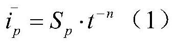
[0152] (1) Calculation of heavy rainfall at design point

[0153] ①Calculation of heavy rainfall at design points 1, 6, and 24: According to the center of gravity of the design watershed, look up the annual maximum 1-hour, 6-hour, and 24-hour once-in-a-century rainfall in the "Rainstorm and Flood Handbook" in Yunnan Province Mean value and its corresponding coefficient of variation, and according to Cs=3.5Cv, find out the modulus coefficient of the one-in-a-century encounter in the attached table, as shown in Table 1, and calculate 1 hour, 6 hours, and 24 hours at the corresponding frequency according to the formula Design point rainstorm volume:

[0154]

[0155] In the formula, H p is the rainstorm duration (t) is 1 hou...


PUM


Abstract

The invention provides a GIS-based medium and small watershed design flood model, and relates to the field of rainstorm flood calculation, and the model comprises the steps: 1, determining a research watershed, and extracting the feature attributes of the research watershed; 2, calculating the water level of a design research basin and the river width of an outlet section; 3, according to a rainstorm flood manual, determining the designed rainstorm flow Hp and time distribution of the designed rainstorm flow Hp of the flood in Ts years; 4, designing and researching drainage basin runoff yield calculation; 5, designing and researching basin confluence calculation; and 6, designing and researching a drainage basin recession process. Parameters of the model are objectified, subjectivity of manual debugging or parameter selection is avoided, so that universality of the model is enhanced, and the problem that design flood precision of medium and small watersheds in areas lack of data is not high is solved.

Description

technical field [0001] The invention relates to the field of storm and flood calculations, in particular to a GIS-based design flood model for small and medium watersheds. Background technique [0002] For small and medium watersheds, especially watersheds with little data or no data, the basic idea of ​​flood model design is to convert rainfall and geographical characteristics data into runoff through analysis and calculation of runoff production and confluence. The main research methods are divided into three categories: 1. Regional empirical synthesis method; 2. . Hydrological basin model method; 3. Morphological survey method (flood survey method); among them, the regional experience synthesis method is to establish the comprehensive function relationship of the region according to the measured data such as rainfall and runoff, and then extend the comprehensive function relationship to the data-deficient area; The method is accurate and reliable, but it needs sufficient ...

Claims


Application Information

Patent Timeline
IPC IPC(8): G06F30/20G06F16/29
CPCG06F16/29Y02A10/40
Inventor 黎小东
Owner SICHUAN UNIV
Why Eureka
Try Eureka