Modular customization method and device for geographic information system software

A geographic information system and modularization technology, applied in the field of modular customization method and device of geographic information system software, can solve problems such as limited functions and inflexibility of embedded development technology, and achieve the effect of labor-saving design

Pending Publication Date: 2021-04-16
中科星通(廊坊)信息技术有限公司
View PDF0 Cites 2 Cited by
  • Summary
  • Abstract
  • Description
  • Claims
  • Application Information

AI Technical Summary

Problems solved by technology

Embedded development technology based on ArcGIS Engine is inflexible, with limited functions and mostl...

Method used


Image

  • Modular customization method and device for geographic information system software
  • Modular customization method and device for geographic information system software
  • Modular customization method and device for geographic information system software

Examples


specific Embodiment

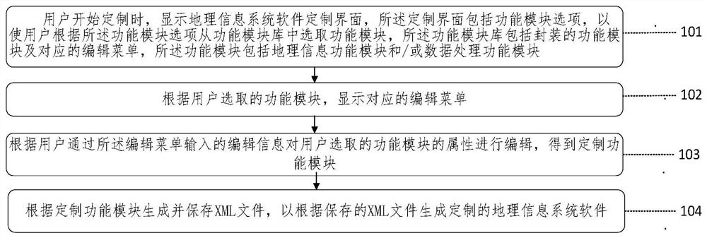
[0071] This embodiment provides a kind of QRST (Quantitative Remote Sensing Technology)_GIAS (Geographic Information Analysis System, geographical information analysis system), this system uses XML to design, generate and use the system, the geographic information that the user designs in the design platform System software will be described by the platform as XML for storage. The corresponding geographic information system software is described in XML, which modules are needed, the attributes of the modules and the mutual binding relationship between the modules. Submit that XML to another program that reads the XML to generate the required GIS software.

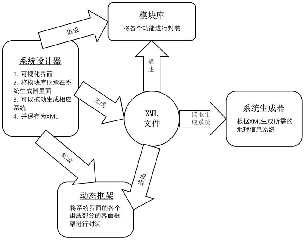
[0072] see figure 2 , the present embodiment comprises three parts: the one, module library, i.e. the encapsulation of each function module; Save as XML; the third is the dynamic framework and system generator. The dynamic framework provides the encapsulation of the system interface and the encapsulation specification of...


PUM


Abstract

The invention discloses a modular customization method and device for geographic information system software, and belongs to the technical field of geographic space data. The method comprises the steps: displaying a geographic information system software customization interface, wherein the customization interface comprises function module options, so that a user can select function modules from a function module library according to the function module options, and the function module library comprise packaged function modules and corresponding editing menus, and the function module comprises a geographic information function module and/or a data processing function module; displaying a corresponding editing menu according to the function module selected by the user; editing the attributes of the function modules selected by the user according to editing information input by the user through the editing menu to obtain customized function modules; and generating and storing an XML file according to the customization function module so as to generate customized geographic information system software according to the stored XML file. A user can design professional geographic information system software more simply and effortlessly without mastering a programming technology.

Description

technical field [0001] The invention relates to the technical field of geospatial data, in particular to a modular customization method and device for geographic information system software. Background technique [0002] In many industries such as transportation, ocean, agriculture, etc., in order to realize intelligent, digital, and visualized geographic information analysis and processing, there are corresponding geographic information analysis and processing software to complete the corresponding work. Such software either uses mature commercial software such as ArcGIS, or directly develops industry-specific geographic information system software for developers, or is secondary development on basic geographic information system software (such as secondary development of ArcEngine). Direct use of commercial software requires a certain amount of learning and purchase costs, and it is inflexible; when developing directly, there are a large number of general-purpose functions...

Claims


Application Information

Patent Timeline
IPC IPC(8): G06F8/20G06F8/34G06F8/38G06F40/143G06F16/29
Inventor 黄祥志王宝玉赵亚萌臧文乾王更科
Owner 中科星通(廊坊)信息技术有限公司
Why Eureka
Try Eureka