Method for accurately displaying current visual field through eagle eye window in three-dimensional map

A three-dimensional map, accurate display technology, applied in image data processing, instrumentation, calculation and other directions, can solve the problems of complex, difficult to accurately calculate the observation range, and high computational complexity, to ensure the calculation accuracy and calculation speed, and facilitate real-time application. Effect

Pending Publication Date: 2021-04-23
PLA STRATEGIC SUPPORT FORCE INFORMATION ENG UNIV PLA SSF IEU +1
View PDF0 Cites 0 Cited by
  • Summary
  • Abstract
  • Description
  • Claims
  • Application Information

AI Technical Summary

Problems solved by technology

[0004] (2) It is difficult to accurately calculate the observation range. The precise observation range needs to consider the horizontal viewing angle and vertical viewing angle, as well as factors such as observation direction, pitch, and roll angle. It is very complicated to properly handle these parameters with traditional methods;
[0005] (3) The observation range polygon needs to emit a large number of intersecting rays during calculation. To ensure sufficient fineness, it is necessary to use extremely fine subdivision granularity, and the calculation complexity is high
CPU-intensive calculations are required

Method used


Image

  • Method for accurately displaying current visual field through eagle eye window in three-dimensional map
  • Method for accurately displaying current visual field through eagle eye window in three-dimensional map
  • Method for accurately displaying current visual field through eagle eye window in three-dimensional map

Examples


Embodiment Construction

[0025] In order to make the content of the present invention clearer and easier to understand, the content of the present invention will be described in detail below in conjunction with specific embodiments and accompanying drawings.

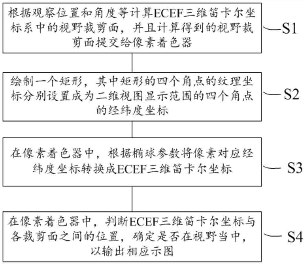
[0026] figure 1 A flowchart schematically shows a method for accurately displaying a current field of view by an eagle-eye window in a three-dimensional map according to a preferred embodiment of the present invention.

[0027] Such as figure 1 As shown, according to a preferred embodiment of the present invention, the eagle eye window in the three-dimensional map accurately displays the method for the current field of view comprising:

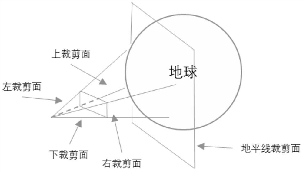
[0028] The first step S1: Calculate the field of view clipping plane in the ECEF (Earth-Centered, Earth-Fixed) three-dimensional Cartesian coordinate system according to the observation position and angle, and submit the calculated field of view clipping plane to the pixel shader;

[0029] For example, mainly,...


PUM


Abstract

The invention provides a method for accurately displaying a current visual field by an eagle eye window in a three-dimensional map, which comprises the following steps of: 1, calculating a visual field cutting surface in an ECEF three-dimensional Cartesian coordinate system according to an observation position, an observation angle and the like, and submitting the calculated visual field cutting surface to a pixel shader; 2, drawing a rectangle, wherein texture coordinates of four corners of the rectangle are respectively set as longitude and latitude coordinates of four corners of a two-dimensional view display range; 3, in a pixel shader, converting longitude and latitude coordinates corresponding to pixels into ECEF three-dimensional Cartesian coordinates according to the ellipsoid parameters; and step 4, in the pixel shader, judging the positions between the ECEF three-dimensional Cartesian coordinates and each cutting surface, and determining whether the ECEF three-dimensional Cartesian coordinates are in the view field or not so as to output a corresponding diagram.

Description

technical field [0001] The invention relates to the technical field of three-dimensional earth visualization, in particular to a method for accurately displaying the current field of view in an eagle eye window in a three-dimensional map, which can quickly and accurately display the geographical range of the current three-dimensional observation in the eagle eye window. Further, the present invention can be extended to application scenarios such as rapidly and accurately displaying the geographical range observed by satellites. Background technique [0002] In the 3D earth visualization technology, it is often necessary to calculate the field of view that can be observed on the earth's surface from any specified observation position and direction in space, and display it in a two-dimensional view. The eagle eye window is one of the usage scenarios. The typical traditional method is: first calculate a series of example lines according to the boundary of the 3D view, find the...

Claims


Application Information

Patent Timeline
IPC IPC(8): G06T19/20G06T17/05
Inventor 陈刚夏青李艳明杨银芩
Owner PLA STRATEGIC SUPPORT FORCE INFORMATION ENG UNIV PLA SSF IEU
Why Eureka
Try Eureka