
Distributed geographic position real-time processing method and system

A technology of geographic location and real-time processing, applied in the field of big data processing, can solve the problems of inaccurate geographic location positioning and lack of place names and addresses, and achieve the effect of reducing inaccurate positioning.

Pending Publication Date: 2021-04-23
深圳市和讯华谷信息技术有限公司
View PDF4 Cites 0 Cited by
  • Summary
  • Abstract
  • Description
  • Claims
  • Application Information

AI Technical Summary

Problems solved by technology

Since there is no unified naming standard and specification for place names and addresses at present, various industry departments and cities carry out data collection management and coding according to their own needs, resulting in multiple codes for the same address, which leads to inaccurate geographical positioning. Happening

Method used


Image

  • Distributed geographic position real-time processing method and system
  • Distributed geographic position real-time processing method and system
  • Distributed geographic position real-time processing method and system

Examples


Embodiment Construction

[0064] Embodiments of the present application provide a method and system for real-time processing of distributed geographic locations, which are used to reduce inaccurate geographic location positioning.

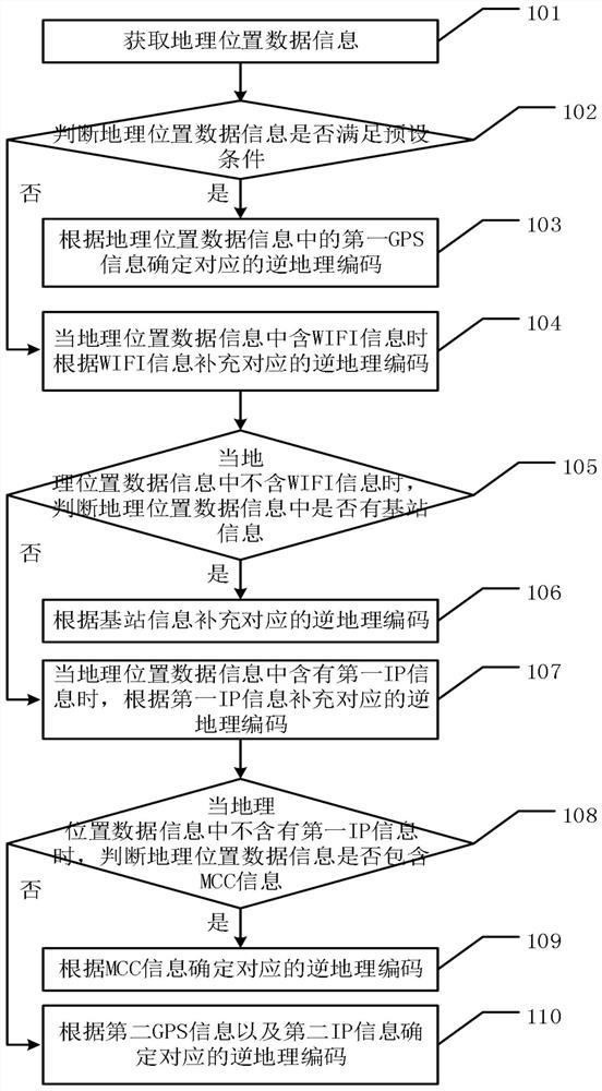
[0065] see figure 1 , the embodiment of the present application uses the system as the description of the execution subject, and an embodiment of the distributed geographic location real-time processing method in the embodiment of the present application includes:

[0066] 101. Obtain geographical location data information;

[0067] In practical application, inverse geocoding is a process of obtaining a corresponding address expression from a geographic coordinate, which is the reverse process of geocoding. The inverse geocoding can be realized by combining each element in the address module according to a certain address module. The system standardizes the matching of the obtained geographical coordinates. When matching the coordinates to the database, the address matchin...


PUM


Abstract

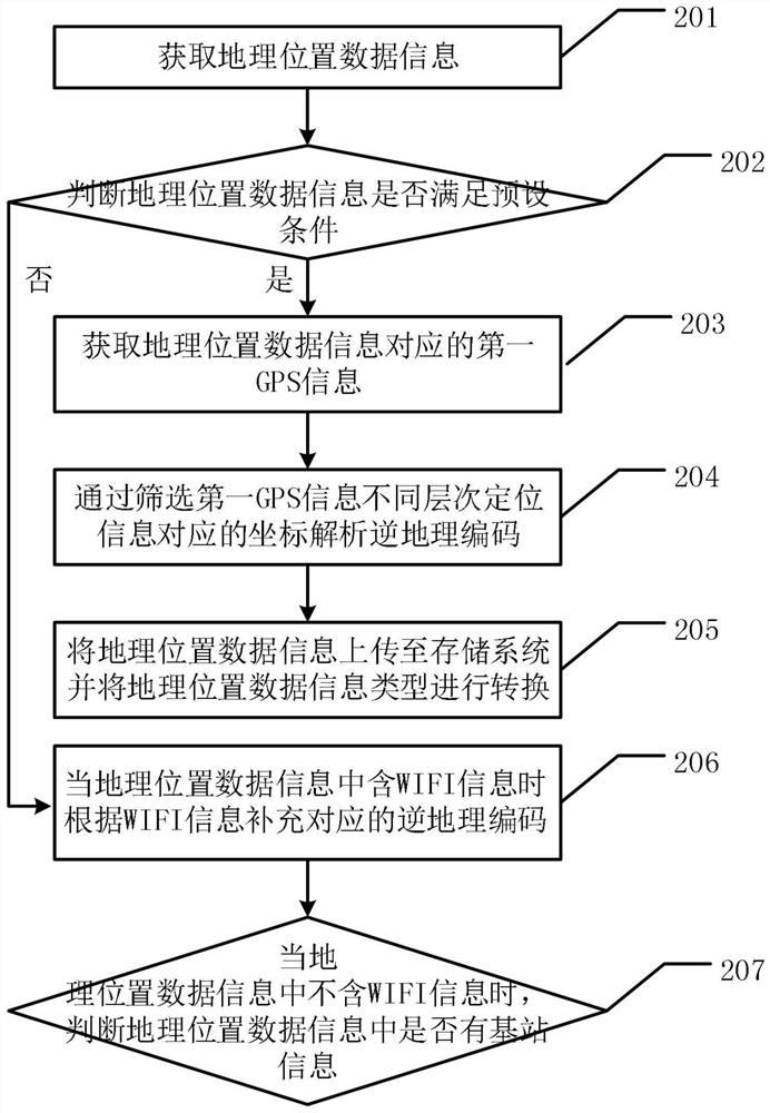
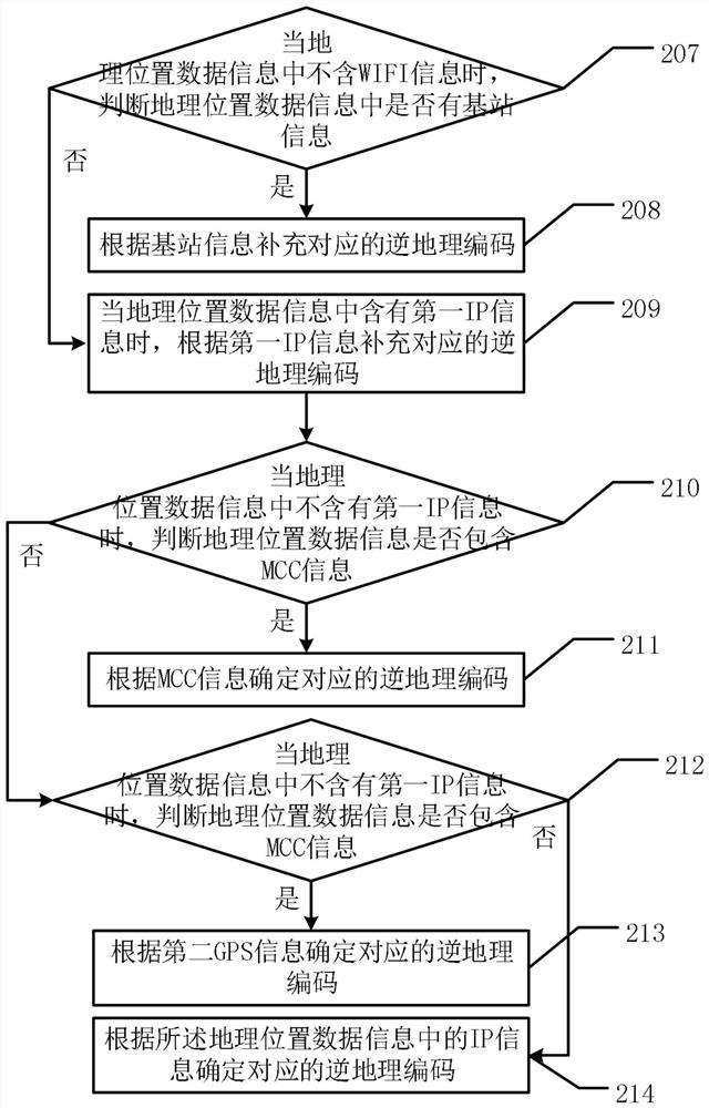
The embodiment of the invention discloses a distributed geographic position real-time processing method and system. The method comprises the following steps: acquiring geographic position data information; judging whether the geographic position data information meets a preset condition or not, and if yes, determining a corresponding inverse geographic code according to first GPS information in the geographic position data information; if not, supplementing the corresponding reverse geocoding according to the WIFI information when the geographic position data information contains the WIFI information; when the geographic position data information does not contain the WIFI information, judging whether base station information exists in the geographic position data information or not, and if yes, supplementing corresponding reverse geocoding according to the base station information; if not, supplementing the corresponding reverse geocoding according to the first IP information when the geographic position data information contains the first IP information; when the geographic position data information does not contain the first IP information, judging whether the geographic position data information contains MCC information or not, and if so, determining a corresponding reverse geographic code according to the MCC information; and if not, determining the corresponding reverse geocoding according to the second GPS information and the second IP information. Therefore, the reverse geocoding corresponding to the geographic position data information in the database is accurately found layer by layer in a distributed manner, and the situation of inaccurate geographic position positioning is reduced.

Description

technical field [0001] The embodiments of the present application relate to the field of big data processing, and in particular to a method and system for real-time processing of distributed geographic locations. Background technique [0002] With the continuous development of Internet technology, it has become more convenient to retrieve and exchange information through computer networks, and there are more and more content related to geographic location information in these networks and exchange information, such as travel routes and directions, cadastral management, real estate, Traffic management and public utility management, etc. The current geographic location information technology can collect and display, and can process and analyze the data in some processes. [0003] In the prior art, spatial positioning technology is a method of converting geographic location information described in natural language into geographic coordinates that can be applied to a geographi...

Claims


Application Information

Patent Timeline
IPC IPC(8): H04L29/08H04L29/12H04W4/02H04W84/12G01S19/03
Inventor 罗伟东段柯柯
Owner 深圳市和讯华谷信息技术有限公司
Learn More