
Engineering geological surveying and mapping method and system based on three-dimensional laser scanning

A technology of engineering geology and 3D laser, which is applied to the details of 3D image data, climate sustainability, instruments, etc., can solve the point cloud data migration, affect the judgment of engineering geology and the selection and stretching of the optimal construction location. and other issues to prevent the wrong selection

Active Publication Date: 2021-05-18
徐一帆 +1
View PDF5 Cites 1 Cited by
  • Summary
  • Abstract
  • Description
  • Claims
  • Application Information

AI Technical Summary

Problems solved by technology

[0003] In practice, the inventor found that the above-mentioned existing technology has the following defects: during the collection of point cloud data, due to the vibration or high-speed movement of the drone, the point cloud data often shifts, stretches, etc. In turn, it affects the judgment of engineering geology and the selection of the optimal construction location

Method used


Image

  • Engineering geological surveying and mapping method and system based on three-dimensional laser scanning
  • Engineering geological surveying and mapping method and system based on three-dimensional laser scanning
  • Engineering geological surveying and mapping method and system based on three-dimensional laser scanning

Examples


Embodiment Construction

[0046]In order to further illustrate the technical means and efficacy of the present invention to achieve the object of the present invention, the followingly, a three-dimensional laser scanning method and system based on three-dimensional laser scanning according to the present invention will be combined with reference to the drawings and preferred embodiments. DETAILED DESCRIPTION OF THE INVENTION, structures, features, and their effects are described in detail. In the following description, different "one embodiment" or "another embodiment" refers to not necessarily the same embodiment. In addition, specific features, structures, or features in one or more embodiments may be combined by any suitable form.

[0047]All techniques and scientific terms used herein are identical to those skilled in the art, unless otherwise defined.

[0048]The specific scheme of the engineering geological mapping method and the system based on three-dimensional laser scanning according to the present inven...


PUM


Abstract

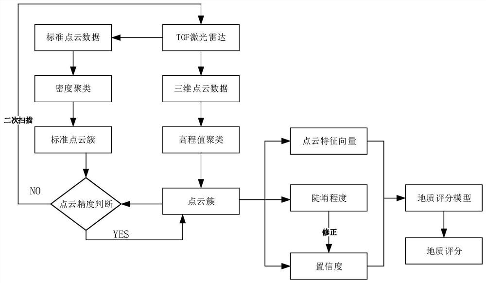
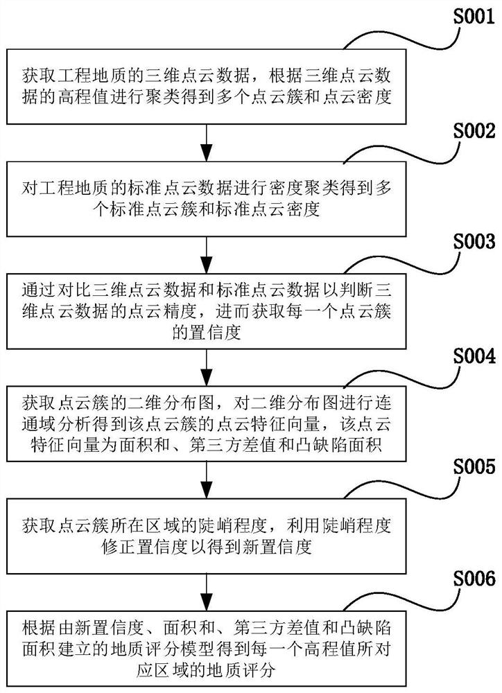
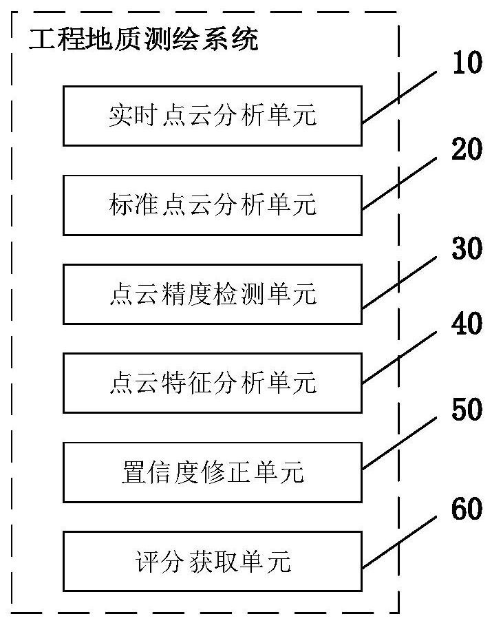
The invention relates to the technical field of artificial intelligence, in particular to an engineering geological surveying and mapping method and system based on three-dimensional laser scanning. The method comprises the following steps: clustering three-dimensional point cloud data of engineering geology to obtain a plurality of point cloud clusters and the point cloud density; obtaining a plurality of standard point cloud clusters and the standard point cloud density by carrying out density clustering on the standard point cloud data of the engineering geology; judging the point cloud precision of the three-dimensional point cloud data by comparing the three-dimensional point cloud data with the standard point cloud data, and then obtaining the confidence coefficient of the point cloud cluster; performing connected domain analysis on the two-dimensional distribution diagram of the point cloud cluster to obtain a point cloud feature vector of the point cloud cluster; correcting the confidence coefficient by using the steep degree of the area where the point cloud cluster is located to obtain a new confidence coefficient; and combining the point cloud feature vector and the new confidence coefficient to obtain a geological score of the corresponding region. Feature analysis is carried out on the three-dimensional point cloud data meeting the point cloud precision, and the distribution features of the three-dimensional point cloud data are analyzed to ensure that an accurate engineering geological score is obtained, thereby preventing a construction position from being selected mistakenly.

Description

Technical field[0001]The present invention relates to the field of artificial intelligence, and in particular to engineering geological mapping methods and systems based on three-dimensional laser scanning.Background technique[0002]Engineering geological mapping is a most important and most basic survey method in engineering geological surveys. Currently, the industry is reconstructed by three-dimensional geological model through three-dimensional point cloud information, which typically uses point cloud data through conventional pretreatment, or a point-worth point cloud data.[0003]In practice, the above prior art has the following defects: point cloud data is from offset, stretching, stretching, etc. due to the vibration or high-speed movement of the drone during the acquisition process. Furthermore, it affects the judgment of engineering geology and the choice of optimal construction position.Inventive content[0004]In order to solve the above technical problems, it is an object o...

Claims


Application Information

Patent Timeline
IPC IPC(8): G06T17/10G06T17/20
CPCG06T17/10G06T17/20G06T2200/04Y02A90/30
Inventor 徐一帆管庆军
Owner 徐一帆
Learn More