River ecological quality evaluation method based on remote sensing technology
A technology of river and quality, applied in the field of river ecological quality evaluation based on remote sensing technology, can solve problems such as inability to effectively reflect the state of river ecosystems, and achieve the effect of overcoming the incomplete evaluation of river ecological quality
- Summary
- Abstract
- Description
- Claims
- Application Information
AI Technical Summary
Problems solved by technology
Method used
Image
Examples
Embodiment Construction
[0024] The present invention will be further elaborated below in conjunction with the accompanying drawings and embodiments.
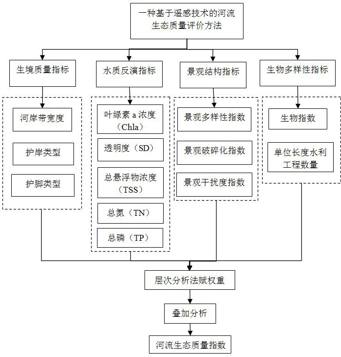
[0025] The invention provides a river ecological quality evaluation method based on remote sensing technology, including four index units including habitat quality index, water quality inversion index, landscape structure index and biodiversity index, and the habitat quality index unit includes the width of the riparian zone 3 index factors, bank protection type and foot protection type, are used to reflect the vegetation coverage on both sides of the river; the water quality inversion index unit includes 5 index factors of chlorophyll a concentration, transparency, total suspended solids concentration, total nitrogen, and total phosphorus. It is used to reflect the quality of river water; the landscape structure index unit includes three index factors: landscape diversity index, landscape fragmentation index and landscape disturbance index, which are u...
PUM
 Abstract
Description
Claims
Application Information
 - R&D
- Intellectual Property
- Life Sciences
- Materials
- Tech Scout
- Unparalleled Data Quality
- Higher Quality Content
- 60% Fewer Hallucinations
Browse by: Latest US Patents, China's latest patents, Technical Efficacy Thesaurus, Application Domain, Technology Topic, Popular Technical Reports.
© 2025 PatSnap. All rights reserved.Legal|Privacy policy|Modern Slavery Act Transparency Statement|Sitemap|About US| Contact US: help@patsnap.com

