Ship depth fusion positioning method based on radar and Beidou data

A technology that integrates positioning and Beidou ships, and is applied to satellite radio beacon positioning systems, measuring devices, instruments, etc., to achieve the effects of improving safety, high precision, and wide applicability

Active Publication Date: 2021-05-28
中船鹏力(南京)大气海洋信息系统有限公司
View PDF9 Cites 2 Cited by
  • Summary
  • Abstract
  • Description
  • Claims
  • Application Information

AI Technical Summary

Problems solved by technology

[0005] In order to overcome the deficiencies of traditional methods in practical application, the present invention proposes a deep fusion positioning method for ships based on radar and Beidou data. Determinism has strong robustness

Method used


Image

  • Ship depth fusion positioning method based on radar and Beidou data
  • Ship depth fusion positioning method based on radar and Beidou data
  • Ship depth fusion positioning method based on radar and Beidou data

Examples


Embodiment Construction

[0073] The present invention will be described in further detail below with reference to the accompanying drawings and specific preferred embodiments.

[0074] In the description of the present invention, it should be understood that the orientation or positional relationship indicated by the terms "left side", "right side", "upper", "lower part", etc. are based on the orientation or positional relationship shown in the drawings, only For the convenience of describing the present invention and simplifying the description, rather than indicating or implying that the referred device or element must have a particular orientation, be constructed and operate in a particular orientation, "first", "second", etc. importance, and therefore should not be construed as a limitation to the present invention. The specific dimensions used in this embodiment are only for illustrating the technical solution, and do not limit the protection scope of the present invention.

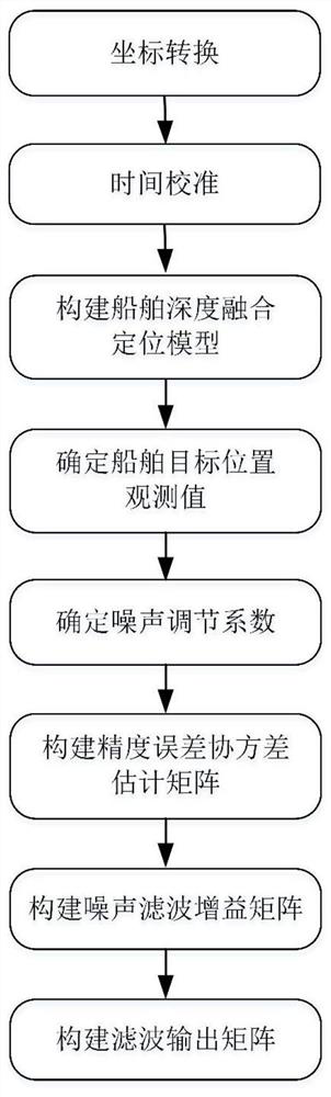
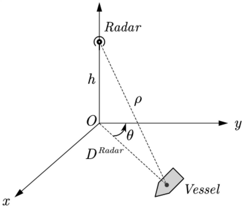
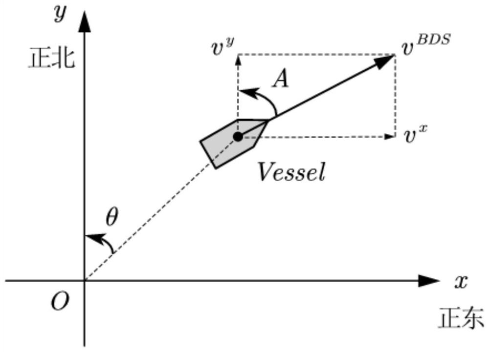
[0075] like figure...


PUM


Abstract

The invention discloses a ship depth fusion positioning method based on radar and Beidou data, which constructs a ship depth fusion positioning model by using ship information acquired by a shore-based radar and ship information provided by a Beidou shipborne terminal, and can realize accurate and reliable positioning of a ship target in a complex water area environment. The method mainly comprises the following steps: firstly, carrying out space-time conversion and unification on radar and Beidou data; then constructing the ship depth fusion positioning model; and finally, carrying out recursive calculation of robust filtering, and obtaining an accurate estimation value of the ship position in real time. According to the method, the position coordinates of the ship can be accurately estimated under the condition that the statistical characteristics of the signal noise cannot be accurately known, and the method has the characteristics of high precision, high reliability, wide applicability and the like.

Description

technical field [0001] The invention relates to the field of multi-source information fusion, in particular to a ship deep fusion positioning method based on radar and Beidou data. Background technique [0002] In order to ensure the safety of ship navigation and improve shipping efficiency, Vessel Traffic Services (VTS) has been widely used in my country's water traffic management departments. VTS uses multi-source information fusion technology to perform fusion positioning of radar target information and AIS target information (Automatic Identification System, automatic identification system for ships), so as to obtain accurate and reliable ship position information. [0003] The traditional fusion positioning method generally sets the signal noise as Gaussian white noise, but in the complex water environment, the uncertain nonlinear noise will change the statistical characteristics of the noise of the sensor, making the noise model preset by the traditional method inconsi...

Claims


Application Information

Patent Timeline
Patent Type & Authority Applications(China)
IPC IPC(8): G01S19/45
CPCG01S19/45
Inventor 夏亮金家龙石志国孙硕彭朋
Owner 中船鹏力(南京)大气海洋信息系统有限公司
Why Eureka
Try Eureka