Method, device and system for improving precision of comprehensive flight path monitoring data of airport apron

A technology for monitoring data and hoisting machines, which is applied in the field of civil aviation, and can solve problems such as unsuitable apron areas, unsatisfactory apron monitoring accuracy, and inability to select suitable marking points or marking lines.

Active Publication Date: 2021-06-08
THE SECOND RES INST OF CIVIL AVIATION ADMINISTRATION OF CHINA
View PDF5 Cites 7 Cited by
  • Summary
  • Abstract
  • Description
  • Claims
  • Application Information

AI Technical Summary

Problems solved by technology

[0006] 2. If it is only for the apron area, sometimes it is impossible to select a suitable marking point or marking line on the electronic map, which makes this method not applicable to the apron area
[0008] Due to the existence of these problems, the monitoring accuracy of the integrated track data of these systems on the apron is not ideal

Method used


Image

  • Method, device and system for improving precision of comprehensive flight path monitoring data of airport apron
  • Method, device and system for improving precision of comprehensive flight path monitoring data of airport apron
  • Method, device and system for improving precision of comprehensive flight path monitoring data of airport apron

Examples


Embodiment 1

[0040] This embodiment is based on the following ideas:

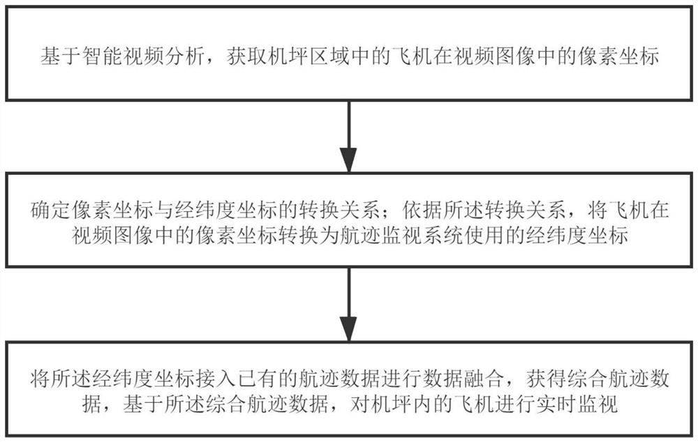
[0041] First of all, the aircraft targets in the apron area are large, and there are high pole lights at night, so the light is ideal; in addition, the apron is a strictly controlled area, and there is no interference from unrelated vehicles and personnel. Based on the above reasons, using the intelligent video analysis technology in the prior art, it is possible to accurately locate and identify the aircraft in the apron area.

[0042] Then, after locating the exact position of the aircraft in the apron area in the image, use measurement and coordinate conversion to convert the pixel coordinates in the image into latitude and longitude coordinates, which are used as a new data source for integrated track data , which is used to improve the accuracy of the comprehensive track data in the apron.

[0043] refer to figure 1 , figure 1 A flow chart of the steps of the method for improving the accuracy of the comprehensiv...

Embodiment 2

[0080] This embodiment is the optimization method of Embodiment 1, specifically:

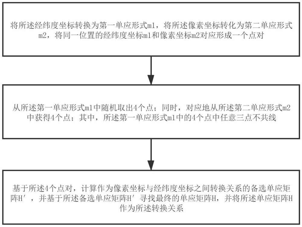
[0081] Embodiment 1 mainly uses intelligent video analysis to obtain the exact position of the target, and then uses the transformation from pixel coordinates to latitude and longitude coordinates to realize the output of the latitude and longitude position of the apron target, thereby increasing the data source of the integrated track monitoring system. It can effectively overcome the shortcomings of the existing ads-b, multipoint positioning and surface surveillance radar systems in the integrated track system in the apron area, and improve the accuracy of the integrated track data. In the transformation from pixel coordinates to latitude and longitude coordinates, RTK equipment is used to measure points in the apron area, so as to obtain a series of point pairs corresponding to latitude and longitude coordinates and pixel coordinates, and then use the algorithm in step 230 to improve calculati...

Embodiment 3

[0129] The present invention also provides a device for improving the accuracy of the comprehensive track monitoring data of the apron, comprising:

[0130] The detection and identification module 40 is used to obtain the pixel coordinates in the video image of the aircraft in the apron area based on intelligent video analysis;

[0131] The coordinate conversion module 42 is used to convert the pixel coordinates of the aircraft in the video image into the latitude and longitude coordinates used by the track monitoring system;

[0132] The data fusion module 44 is used for connecting the latitude and longitude coordinates to the existing track data for data fusion to obtain comprehensive track data, and based on the comprehensive track data, real-time monitoring of aircraft in the apron.

[0133] In the following, the above three modules will be described one by one.

[0134] First, the identification module 40 is detected. This module is used to obtain the pixel coordinates ...


PUM


Abstract

The invention provides a method, a device and a system for improving the precision of comprehensive flight path monitoring data of an airport apron, and the method comprises the steps: obtaining the pixel coordinates of an airplane in an airport apron region in a video image based on intelligent video analysis; determining a conversion relation between the pixel coordinates and the latitude and longitude coordinates; converting pixel coordinates of the airplane in the video image into latitude and longitude coordinates used by a flight path monitoring system; and accessing the latitude and longitude coordinates into the existing flight path data for data fusion to obtain comprehensive flight path data, and monitoring the airplane in the airport apron in real time based on the comprehensive flight path data. According to the invention, the pixel coordinates are efficiently and accurately converted into the latitude and longitude coordinates by adopting an approximate plane mapping and double-sided mapping method, the pixel coordinates of an airplane in a video image are accurately converted into the latitude and longitude coordinates used by a flight path monitoring system, and the precision of latitude and longitude coordinate data is improved; and the precision of the comprehensive track data in the airport apron is effectively improved.

Description

technical field [0001] The invention relates to the technical field of civil aviation, in particular to a method, a device and a system for improving the accuracy of apron comprehensive track monitoring data. Background technique [0002] The most commonly used monitoring method in civil aviation airports is to use integrated track data for real-time display. The integrated track data is integrated with various airport monitoring systems, such as ADS-B, multi-point positioning, surface surveillance radar, A-CDM, etc., in order to achieve more Rich data display and higher monitoring accuracy. [0003] In actual use, there are some limitations in the integrated track access data, especially for the apron area. For example, the signal coverage of ADS-B on the apron is not good, and the problem of target loss often occurs; The positioning accuracy of the apron is not enough. The European Air Traffic Network Management Organization (EUROCONTROL) has given the accuracy standard o...

Claims


Application Information

Patent Timeline
Patent Type & Authority Applications(China)
IPC IPC(8): G08G5/00G06K9/00G06K9/62
CPCG08G5/0073G06V20/41G06F18/25
Inventor 姚辉王凯高勇唐墨臻
Owner THE SECOND RES INST OF CIVIL AVIATION ADMINISTRATION OF CHINA
Why Eureka
Try Eureka