A Simulation Performance Evaluation Method for Satellite Navigation Ground-Based Augmentation System

A ground-based augmentation system and satellite navigation technology, applied in the field of satellite navigation ground-based augmentation system performance evaluation, can solve problems such as inability to cover error scenarios, inability to evaluate methods and equipment operation, and high time costs, so as to avoid human experience and subjective judgment. Dependence, accurately reflect the actual environmental impact, improve the efficiency of iteration and improvement

Active Publication Date: 2021-05-04
NO 20 RES INST OF CHINA ELECTRONICS TECH GRP +1
View PDF10 Cites 0 Cited by
  • Summary
  • Abstract
  • Description
  • Claims
  • Application Information

AI Technical Summary

Problems solved by technology

[0004] The conventional assessment methods described above have their own drawbacks
Although the first method of using the simulator uses various artificial error scenarios, the real operating environment is more complex, and the artificially simulated error scenarios cannot fully cover the actual situation, making the results of simulation evaluation and the results of running in the real environment There are differences, and it is impossible to effectively evaluate the actual operation of the methods and equipment used
The second method uses actual equipment to collect data for long-term operation in the actual operating environment for evaluation. Although the results are highly reliable, the equipment cannot generally be changed during the airworthiness certification stage, so if the method and equipment need to be adjusted and improve, it is necessary to start collecting data again
Since this method requires the installation of equipment in the field and long-term monitoring, the cost of test and evaluation is about one million yuan per year, and the evaluation cycle is extremely long and time-consuming
Not suitable for evaluating new technologies and approaches that require rapid iteration and improvement

Method used


Image

  • A Simulation Performance Evaluation Method for Satellite Navigation Ground-Based Augmentation System
  • A Simulation Performance Evaluation Method for Satellite Navigation Ground-Based Augmentation System

Examples


Embodiment Construction

[0047] The present invention will be further described below in conjunction with the accompanying drawings and embodiments.

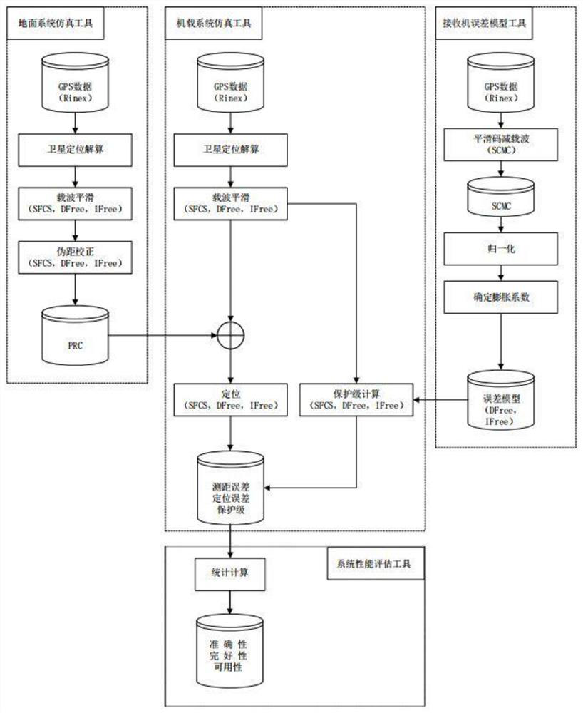
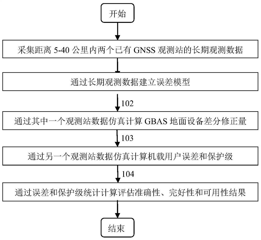
[0048] The satellite navigation Ground-Based Augmentation System (GBAS) simulation performance evaluation system designed and realized based on the real GNSS receiver data realizes the effective performance evaluation of the new method and the effect of the new equipment used in the GBAS research. The system consists of figure 1 shown. The invention provides a kind of satellite navigation ground-based augmentation system (GBAS) simulation performance evaluation method based on real GNSS receiver data, it is characterized in that comprising the following steps:

[0049] Extract the long-term (more than 1 year) observation data of two GNSS observation stations within the range of 5-40 kilometers at the same time. The data include pseudo-range observation data, carrier observation data, ephemeris data, and almanac data. In general RENIX format;

[0050]...


PUM


Abstract

The invention provides a simulation performance evaluation method of a satellite navigation ground-based augmentation system, which extracts observation data, statistically calculates the error function related to the satellite elevation angle, and establishes an error model; performs satellite position positioning and calculation through ephemeris and time, and obtains the observation time Calculate the broadcast pseudo-range correction amount corresponding to the satellite position; obtain the positioning error, obtain the calculation result of the protection level, and obtain the evaluation results of the accuracy, availability and integrity of the GBAS system through the positioning error and protection level results obtained through statistics. The invention avoids spending a lot of economic cost and time cost to install and test the field equipment, improves the efficiency of iterating and improving new methods and equipment, and greatly saves the cost of actual testing.

Description

technical field [0001] The invention relates to satellite navigation data processing, in particular to a satellite navigation ground-based augmentation system (GBAS) performance evaluation method. Background technique [0002] When evaluating the performance of GBAS, the integrity, availability and accuracy of the system are very important evaluation indicators. The assessment of system integrity, availability and accuracy is related to the reality of the system environment and the amount of data used for assessment. The longer the system test runs, the greater the amount of data available for evaluation, and the closer the environment in which the system test runs is to the actual operating environment, the more accurate the evaluation results and the higher the credibility of the evaluation. [0003] There are two traditional evaluation methods for civil aviation GBAS equipment. One is in the technical research stage, mainly using the GNSS signal generated by the simulato...

Claims


Application Information

Patent Timeline
Patent Type & Authority Patents(China)
IPC IPC(8): G01S19/23
CPCG01S19/23
Inventor 王岸石褚映红赵毓譞陈楚天胡耀坤苏从兵陈武广王雪峰
Owner NO 20 RES INST OF CHINA ELECTRONICS TECH GRP
Why Eureka
Try Eureka