A visual simulation method and system for traffic data based on AI recognition
A simulation method and traffic data technology, applied in the direction of design optimization/simulation, character and pattern recognition, special data processing applications, etc., can solve the problem of inability to effectively complete the spatio-temporal behavior analysis of video target objects, regional state monitoring, large data volume, traffic problems, etc. To solve problems such as limited information, achieve the effect of simple and easy to operate, improve the level and efficiency, and facilitate the error correction of driving trajectory
- Summary
- Abstract
- Description
- Claims
- Application Information
AI Technical Summary
Problems solved by technology
Method used
Image
Examples
Embodiment 1
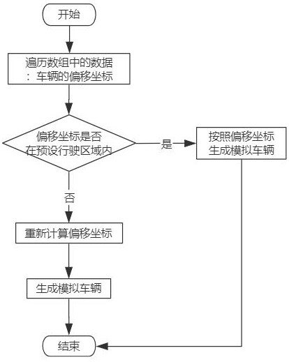
[0076] see figure 1 , the present embodiment provides a traffic data visualization simulation method based on AI identification, the method includes the following steps:
[0077] S1. Build a digital twin city based on a real city;
[0078] Specifically, the map of the city is obtained, and according to the map data, a digital twin city is built in the development platform according to the real ratio. The development platform includes UE4, Unity, Unigine, OSG. Preferably, in this embodiment, the UE4 development platform.
[0079] S2. Obtain the real road monitoring video corresponding to the digital twin city, and divide the preset driving area in the digital twin city according to the monitoring area of the monitoring video;
[0080] Specifically, the road monitoring video includes the aerial video of the UAV and the video taken by the road monitoring camera, wherein the aerial video of the UAV needs to be photographed obliquely, and the front or rear of the vehicle needs ...
Embodiment 2
[0165] Corresponding to the above method embodiment, the embodiment of the present disclosure also provides a traffic data visualization simulation system based on AI recognition, the traffic data visualization simulation system based on AI recognition described below is the same as the traffic data visualization simulation system based on AI recognition described above Data visualization simulation methods can be used for mutual reference.
[0166] The system includes the following modules:
[0167] Modeling unit: build a digital twin city based on a real city;
[0168] Receiving unit: obtain the real road monitoring video corresponding to the digital twin city, and divide the preset driving area in the digital twin city according to the monitoring area of the monitoring video;
[0169] Recognition unit: divide the monitoring video according to the number of frames to obtain several frames of images, identify vehicle information in each frame of images, and the vehicle inf...
Embodiment 3
[0182] Corresponding to the above method embodiment, the embodiment of the present disclosure also provides a traffic data visualization simulation device based on AI recognition, a congestion simulation device based on real-time traffic data described below and an AI recognition-based simulation device described above The visualization simulation methods of traffic data can be referred to each other.
[0183] The electronic device may include: a processor and a memory. The electronic device may also include one or more of a multimedia component, an input / output (I / O) interface, and a communication component.
[0184] Wherein, the processor is used to control the overall operation of the electronic device, so as to complete all or part of the steps in the above-mentioned traffic data visualization simulation method based on AI recognition. The memory is used to store various types of data to support the operation of the electronic device, such data may include instructions fo...
PUM
 Abstract
Description
Claims
Application Information
 - R&D
- Intellectual Property
- Life Sciences
- Materials
- Tech Scout
- Unparalleled Data Quality
- Higher Quality Content
- 60% Fewer Hallucinations
Browse by: Latest US Patents, China's latest patents, Technical Efficacy Thesaurus, Application Domain, Technology Topic, Popular Technical Reports.
© 2025 PatSnap. All rights reserved.Legal|Privacy policy|Modern Slavery Act Transparency Statement|Sitemap|About US| Contact US: help@patsnap.com


