Automatic monitoring and recognition method for salinized land

A technology for automatic monitoring and identification methods, applied in character and pattern recognition, scene recognition, machine learning, etc., to reduce secondary salinization problems and reduce costs.

Active Publication Date: 2021-06-22
TSINGHUA UNIV
View PDF8 Cites 5 Cited by
  • Summary
  • Abstract
  • Description
  • Claims
  • Application Information

AI Technical Summary

Problems solved by technology

[0004] The purpose of the present invention is to propose a method for automatic monitoring and identification of saline-alkali soil in order to overcome the problem that existing forecasting methods cannot automatically monitor and identify salinized soil simply and accurately

Method used


Image

  • Automatic monitoring and recognition method for salinized land
  • Automatic monitoring and recognition method for salinized land
  • Automatic monitoring and recognition method for salinized land

Examples


Embodiment Construction

[0041] The present invention proposes an automatic monitoring and identification method for saline-alkali land, which will be further described in detail below in conjunction with specific embodiments.

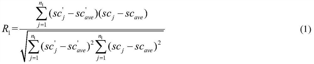
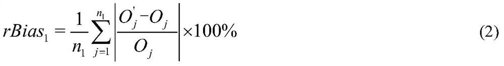
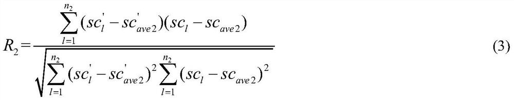
[0042] The invention proposes a method for automatic monitoring and identification of salinized land. The method first obtains the soil salinity data of several sampling points in the research area to form a sample data set; extracts the distance from the research area to the sampling month according to the latitude and longitude of each sampling point In recent remote sensing images, the longitude and latitude correspond to several band values ​​of the grid, and the band combination set is obtained by constructing different band combination forms; then the machine learning soil salinity inversion model is constructed, and the model is trained using the sample data set. Select the band combination form suitable for inversion of soil salinity in the study area from the band comb...


PUM


Abstract

The invention provides an automatic monitoring and recognition method for salinized land, and belongs to the field of environmental monitoring and environmental ecological protection. The method comprises the following steps: collecting soil salt contents of a plurality of sampling points in a research area to form a sample data set; extracting a plurality of wave band values of grids corresponding to the longitude and latitude in the remote sensing image closest to the sampling month according to the longitude and latitude of each sampling point, and obtaining a wave band combination set by constructing different wave band combination forms; then constructing a machine learning soil salt content inversion model, training the model by using the sample data set, and selecting a wave band combination form suitable for inverting the soil salt content of the research area from the wave band combination set to form a sensitive factor set and an optimal inversion model; and obtaining a soil salt content inversion result in a selected month in the research area by using the optimal inversion model. The method can be practically applied to monitoring the salinization degree of the surface soil layer of the arid and semi-arid region and recognizing the salinized soil of different degrees, and provides effective reference basis for local irrigation planning, agricultural management and the like.

Description

technical field [0001] The invention belongs to the field of environmental monitoring and environmental ecological protection, and in particular relates to an automatic monitoring and identification method for salinized land. Background technique [0002] At present, soil salinization has become one of several natural phenomena that affect agricultural production and human life, especially in arid and semi-arid areas. Soil salinization is more serious under the influence of other factors. In addition, frequent agricultural irrigation activities will cause secondary salinization, which intensifies the threat to agricultural production. The use of remote sensing images to monitor and identify saline-alkali land in the basin can guide regional water resources planning and management, especially to effectively guide local irrigation and agricultural water use and soil improvement, which is of great significance to the improvement of the ecological environment and sustainable dev...

Claims


Application Information

Patent Timeline
Patent Type & Authority Applications(China)
IPC IPC(8): G06K9/00G06K9/62G06N20/00
CPCG06N20/00G06V20/13G06F18/214Y02A90/30
Inventor 张腾王忠静张子雄石羽佳索滢杨志刚
Owner TSINGHUA UNIV
Why Eureka
Try Eureka