Remote sensing image road extraction method and device

A technology of road extraction and remote sensing images, applied in the field of surveying and mapping, can solve the problems of changing road shapes, small proportions, disconnections, etc., and achieve the effect of enhancing recognition ability, ensuring completeness and accuracy

Pending Publication Date: 2021-06-25
BEIJING UNIV OF TECH
View PDF0 Cites 0 Cited by
  • Summary
  • Abstract
  • Description
  • Claims
  • Application Information

AI Technical Summary

Problems solved by technology

[0004] Although remote sensing images can quickly and objectively obtain large-scale surface data, the road area accounts for a small proportion of the entire remote sensing image, and the shape of the road is variable, and the road material is different, which will lead to different colors and shapes of the road on the remote sensing image. In particular, roads extracted from remote sensing images often appear discontinuous and disconnected.

Method used


Image

  • Remote sensing image road extraction method and device
  • Remote sensing image road extraction method and device
  • Remote sensing image road extraction method and device

Examples


Embodiment Construction

[0041] In order to make the purpose, technical solutions and advantages of the present invention clearer, the technical solutions in the present invention will be clearly and completely described below in conjunction with the accompanying drawings in the present invention. Obviously, the described embodiments are part of the embodiments of the present invention , but not all examples. Based on the embodiments of the present invention, all other embodiments obtained by persons of ordinary skill in the art without making creative efforts belong to the protection scope of the present invention.

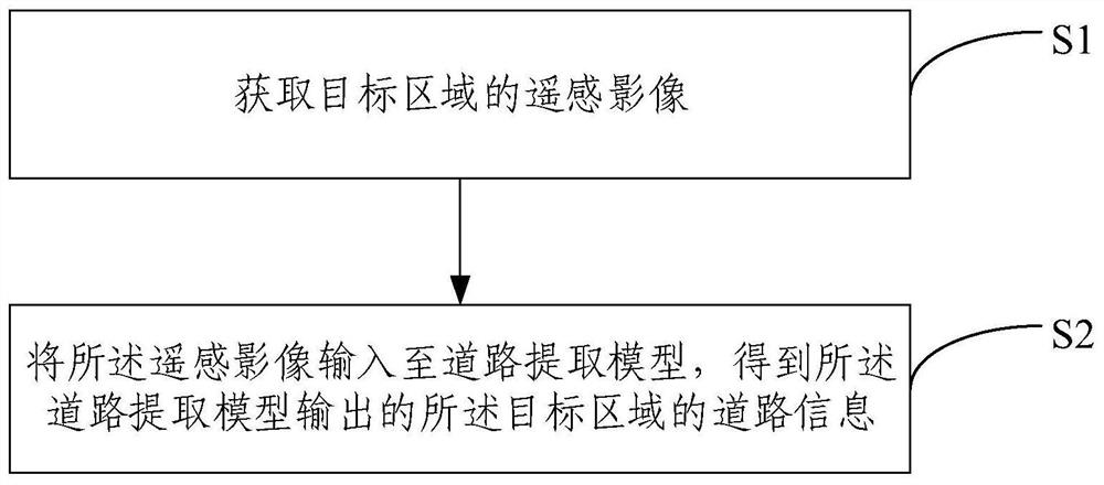
[0042] figure 1 It is a schematic flow chart of a remote sensing image road extraction method provided in an embodiment of the present invention, such as figure 1 As shown, the method includes:

[0043] S1, acquiring the remote sensing image of the target area;

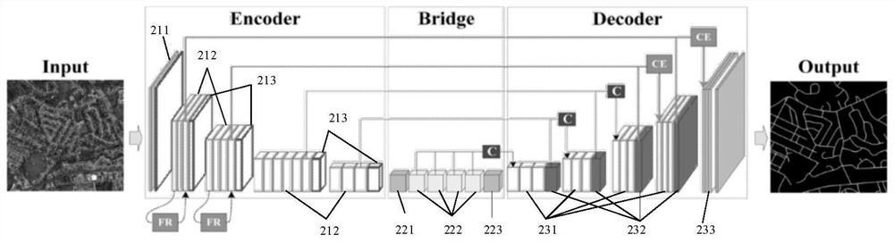
[0044] S2. Input the remote sensing image into a road extraction model, and obtain the road information of the target area ...


PUM


Abstract

The invention provides a remote sensing image road extraction method and device. The method comprises the following steps: firstly, acquiring a remote sensing image of a target area; then inputting the remote sensing image into a road extraction model, extracting and enhancing road contour features in the remote sensing image through the road extraction model, performing multi-scale feature extraction and fusion on the obtained road contour enhanced features, extracting road information of a target area based on the obtained multi-scale fusion features, and finally outputting the road information of the target area. By enhancing the road contour features and fusing the multi-scale features, the recognition capability of the road extraction model on the road contour can be enhanced, so that the integrity and accuracy of the road information obtained by recognition are better ensured.

Description

technical field [0001] The invention relates to the technical field of surveying and mapping, in particular to a method and device for extracting roads from remote sensing images. Background technique [0002] Road changes, including new road mileage, are very important basic data in road asset management and maintenance. At the same time, high-precision maps for unmanned driving also need to quickly update road information. Therefore, it has very important practical significance and research value to use new technology to quickly and objectively perceive the road status. [0003] Geographic information collection technologies, such as total stations and global positioning systems (Global Positioning System, GPS), are not only inefficient in collecting data on normal operating roads, but also can only obtain limited point data, which cannot fully display the whole picture of the road. Although Street View data provides clear road images, it is easily blocked due to the col...

Claims


Application Information

Patent Timeline
IPC IPC(8): G06K9/62G06N3/02G06T7/149
CPCG06T7/149G06N3/02G06T2207/10032G06F18/253G06F18/214
Inventor 王金司琦张子宜
Owner BEIJING UNIV OF TECH
Why Eureka
Try Eureka