Elevation measurement method and system

A height measurement and height technology, applied in the field of height measurement, can solve problems such as inconvenient operation, difficult adjustment and correction, and large error accumulation, and achieve the effect of simple and efficient use, overcoming low operation accuracy, and quick installation

Pending Publication Date: 2021-07-02
THE 4TH CONSTR ENG CO LTD OF CHINA RAILWAY NO 4 ENG GRP +1
View PDF0 Cites 3 Cited by
  • Summary
  • Abstract
  • Description
  • Claims
  • Application Information

AI Technical Summary

Problems solved by technology

[0003] The traditional elevation measurement method is not perfect enough. The operation accuracy of the steel ruler is low. At the same time, the operation is inconvenient. D

Method used


Image

  • Elevation measurement method and system
  • Elevation measurement method and system
  • Elevation measurement method and system

Examples


Embodiment 1

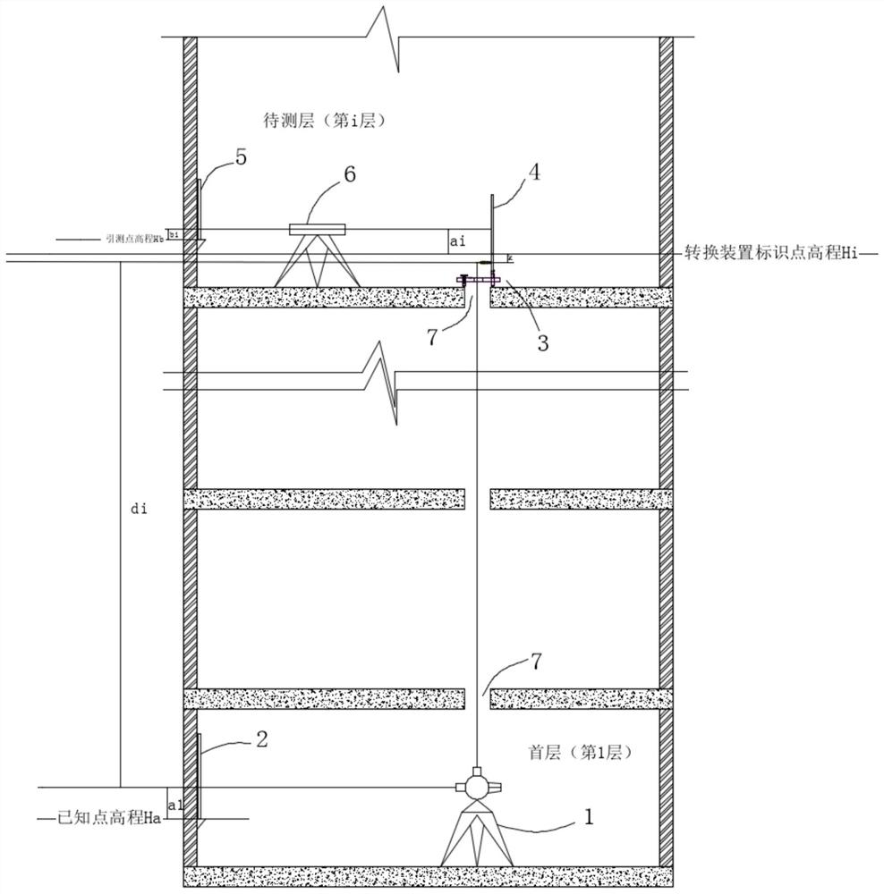
[0034] The transfer point of the elevation is set at the axis control point of the first floor, and the vertical upward transfer is realized by piercing through holes in the vertical direction from the first floor to the layer to be measured.

[0035] Described elevation measuring system comprises the total station 1 that is installed on the first floor, and the level instrument 6 that is installed on the layer to be measured, conversion device 3, the first leveling rod 4 and the second leveling rod 5, here, utilize total station 1 Zenith distance function, through the reference point of the first floor elevation, lead measurement to the conversion device 3 of the elevation of the construction layer (that is, the layer to be measured), and use the level 6 to guide the measurement of the elevation on the conversion device 3 to the construction layer, breaking through The traditional steel ruler has many disadvantages, such as low operating accuracy and inconvenient operation, la...

Embodiment 2

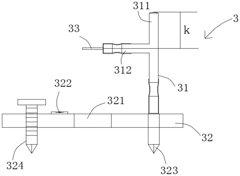
[0044] A conversion device is provided, the conversion device 3 includes an adjustment base 32 and a converter 31, the converter 31 is detachably erected on one side of the adjustment base 32, and the apex of the converter 31 is used as An identification point that identifies the elevation. It further lies in that the converter 31 includes a vertical bar 311 and a horizontal bar 312, and one end of the horizontal bar 312 is fixed on the middle section of the vertical bar 311. It should be pointed out here that this embodiment does not Define the specific position where the crossbar 312 is fixed in the middle section, which needs to meet the requirements of the crossbar 312 after the prism lens 33 is assembled. Cooperate use; Simultaneously, the axis of described horizontal bar 312 and the axis of vertical bar 311 intersect vertically, be positioned at intersection point to the top of vertical bar 311 as the distance constant K of above-mentioned mark point, in practice, prism ...

Embodiment 3

[0047] A height measurement method, comprising the following steps:

[0048] Obtain the elevation of the known point on the first floor according to the known benchmarking point, and the elevation of the known point is the first height value Ha;

[0049] According to the elevation of the known point on the first floor, the elevation line distance from its center to the elevation of the known point on the first floor is obtained by the total station 1, and the elevation line distance is the second height value a1;

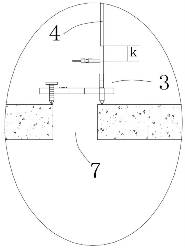
[0050] The first layer to the layer to be measured is vertically pierced with a through hole 7, and a prism lens 33 is arranged at the through hole of the layer to be measured. The prism lens 33 is installed on the conversion device 3, and the telescope of the total station 1 is directed to the prism The lens 33 coincides with the center of the prism lens 33, and the total station 1 is operated to measure the distance and obtain the distance, and the distance is the...


PUM


Abstract

The invention discloses an elevation measurement method and system. The method comprises the steps that the elevation of a first-layer known point is acquired; the elevation line distance from the center of a total station to the elevation of the first-layer known point is acquired through the total station; a through hole is formed in the vertical direction from the first layer to a layer to be measured in a penetrating mode, a prism head is arranged at the through hole of the layer to be measured, a telescope of the total station vertically points to the prism head and coincides with the center of the prism head, and the total station is operated to measure the distance and obtain the distance; a conversion device provided with the prism head has an identification elevation, and an identification point distance constant K from the prism head to the identification elevation is measured; a level gauge is installed on the layer to be measured, and a first leveling rod is erected at the top of the elevation mark Hi of the conversion device; and a second leveling rod is erected at the elevation Hb of the guide measurement point of the to-be-measured layer. According to the method, the zenith distance function of the total station is utilized, the first-layer elevation datum point is guided to be measured to the conversion device of the elevation of the layer to be measured through the first-layer elevation datum point, and then the elevation on the conversion device is guided to be measured to the layer to be measured through the level gauge.

Description

technical field [0001] The invention relates to the technical field of elevation measurement, in particular to an elevation measurement method and system. Background technique [0002] The transmission of the elevation of the ground part of the traditional super high-rise ±0.000m adopts the method of hanging steel rulers. Pass at least three points at a time and check against each other. According to the elevation control point of the first floor, use a qualified steel ruler to measure directly upward along the structure. The steel ruler measurement distance should use standard tension, and correct the ruler length and temperature. The measuring distance of the steel ruler should use the standard tensile force, and correct the length and temperature of the ruler. The atmospheric temperature, component temperature and steel ruler temperature of the environment at that time must be measured on site. Each measurement should be re-measured from the reference point, and then co...

Claims


Application Information

Patent Timeline
IPC IPC(8): G01C5/00
CPCG01C5/00
Inventor 胡劲辉陈小文金涛张贵虎刘文明周菲刘永丽
Owner THE 4TH CONSTR ENG CO LTD OF CHINA RAILWAY NO 4 ENG GRP
Why Eureka
Try Eureka