Logistics management method based on Beidou satellite positioning technology

A technology of logistics management and positioning technology, which is applied in the services based on location information, services based on specific environments, logistics, etc., and can solve the problems of poor communication signal quality, difficulty in ensuring full coverage of communication signals in mountainous areas, and difficulty in meeting frequency band resources. , to achieve the effect of improving transmission efficiency

Active Publication Date: 2021-07-09
ZHEJIANG WANLI UNIV
View PDF11 Cites 0 Cited by
  • Summary
  • Abstract
  • Description
  • Claims
  • Application Information

AI Technical Summary

Problems solved by technology

[0003] In logistics transportation, once the logistics vehicle drives to the mountainous area, due to the special geographical environment of the mountainous area, there are fewer communication base stations in the mountainous area, and it is basically difficult to ensure full coverage of communication signals in the mountainous area, and the quality of communication signals in the mountainous area is also relatively low. Poor, usually intermittent signal occurs
Once emergencies such as mudslides and earthquakes occur, the terminal devices held by many users in mountainous areas will have the need to communicate with the outside world at almost the same time or at the same time period, which will inevitably lead to a blowout growth in the demand for idle frequency bands in mountainous areas, resulting in The originally scarce frequency band resources in the mountainous area can hardly meet the communication needs of the logistics vehicles responsible for emergency transportation driving in the mountainous area and the management of the logistics company, and then cannot meet the management requirements of the logistics company for logistics vehicles and goods

Method used


Image

  • Logistics management method based on Beidou satellite positioning technology
  • Logistics management method based on Beidou satellite positioning technology
  • Logistics management method based on Beidou satellite positioning technology

Examples


Embodiment Construction

[0048] The present invention will be further described in detail below in conjunction with the accompanying drawings and embodiments.

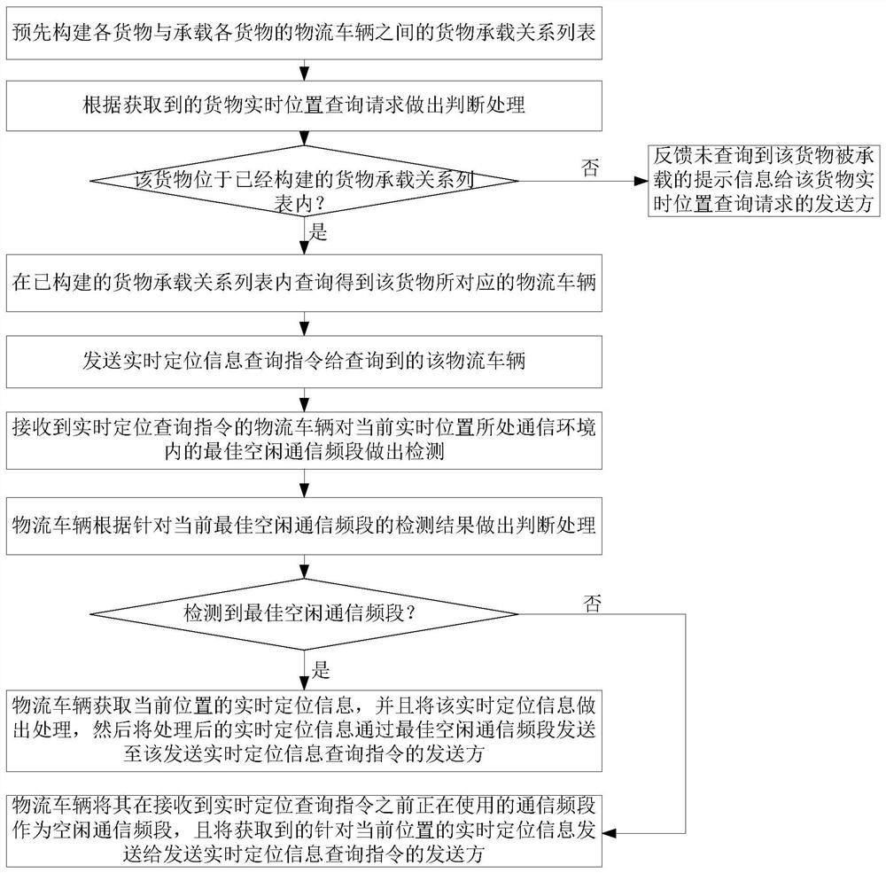
[0049] This embodiment provides a logistics management method based on Beidou satellite positioning technology, which is suitable for locating goods in the process of logistics transportation, especially suitable for locating and managing logistics vehicles driving in a mountainous environment. Specifically, see figure 1 As shown, the logistics management method based on Beidou satellite positioning technology in this embodiment includes the following steps 1-8:

[0050] Step 1. The management side of the logistics company pre-constructs a list of cargo carrying relationships between each cargo and the logistics vehicle that carries each cargo; each cargo corresponds to a logistics vehicle that carries the cargo, and each logistics vehicle is equipped with a Beidou positioning The system and the spectrum sensing device, the spectrum sensing d...


PUM


Abstract

The invention relates to a logistics management method based on a Beidou satellite positioning technology, and the method comprises the steps: building a cargo bearing relation list in advance through a logistics management side, enabling the logistics management side to carry out the comparison and judgment of the cargo information and the cargo bearing relation list when receiving an external cargo query instruction for determining a specific logistics vehicle for transporting a to-be-monitored cargo; then sending the to-be-monitored cargo to a corresponding logistics vehicle in transportation, and then sending the to-be-monitored cargo to the corresponding logistics vehicle in transportation; after the logistics vehicle detects an optimal idle communication frequency band at the position where the logistics vehicle is located, sending, by the logistics vehicle, the video monitoring data of the to-be-monitored goods and the real-time position information of the logistics vehicle to a logistics management party located at a far end through the current optimal idle communication frequency band. According to the invention, the logistics vehicle can send the monitoring video data to the logistics management party at the far end in time when the communication frequency band is in shortage, and therefore, the logistics monitoring efficiency and the management efficiency are improved.

Description

technical field [0001] The invention relates to the field of logistics management, in particular to a logistics management method based on Beidou satellite positioning technology. Background technique [0002] In the current domestic logistics industry, logistics companies will install the Beidou system on every logistics vehicle in charge of cargo transportation managed by the company according to supervision and their own management needs, so as to meet the monitoring needs of logistics vehicles during transportation, such as Realize the real-time positioning and trajectory monitoring of logistics vehicles to ensure the safe transportation of logistics vehicles and the safety of goods. [0003] In logistics transportation, once the logistics vehicles drive to the mountainous area, due to the special geographical environment of the mountainous area, there are fewer communication base stations in the mountainous area, and it is basically difficult to ensure full coverage of ...

Claims


Application Information

Patent Timeline
Patent Type & Authority Applications(China)
IPC IPC(8): H04B17/382H04W4/02H04W4/40H04N7/18G06Q10/08G16Y10/40G16Y20/10G16Y40/10G16Y40/60
CPCH04B17/382H04W4/02H04W4/40H04N7/18G06Q10/0833G16Y10/40G16Y20/10G16Y40/10G16Y40/60Y02D30/70
Inventor 王艳玲郑紫微
Owner ZHEJIANG WANLI UNIV
Why Eureka
Try Eureka